Map Of Poland | Cities, Roads, And Top Attractions
Use this comprehensive map of Poland to understand the country’s geography, including its regions, cities, and landmarks.
Author:Finn WildeReviewer:Michael RachalOct 21, 202544.3K Shares821.5K Views
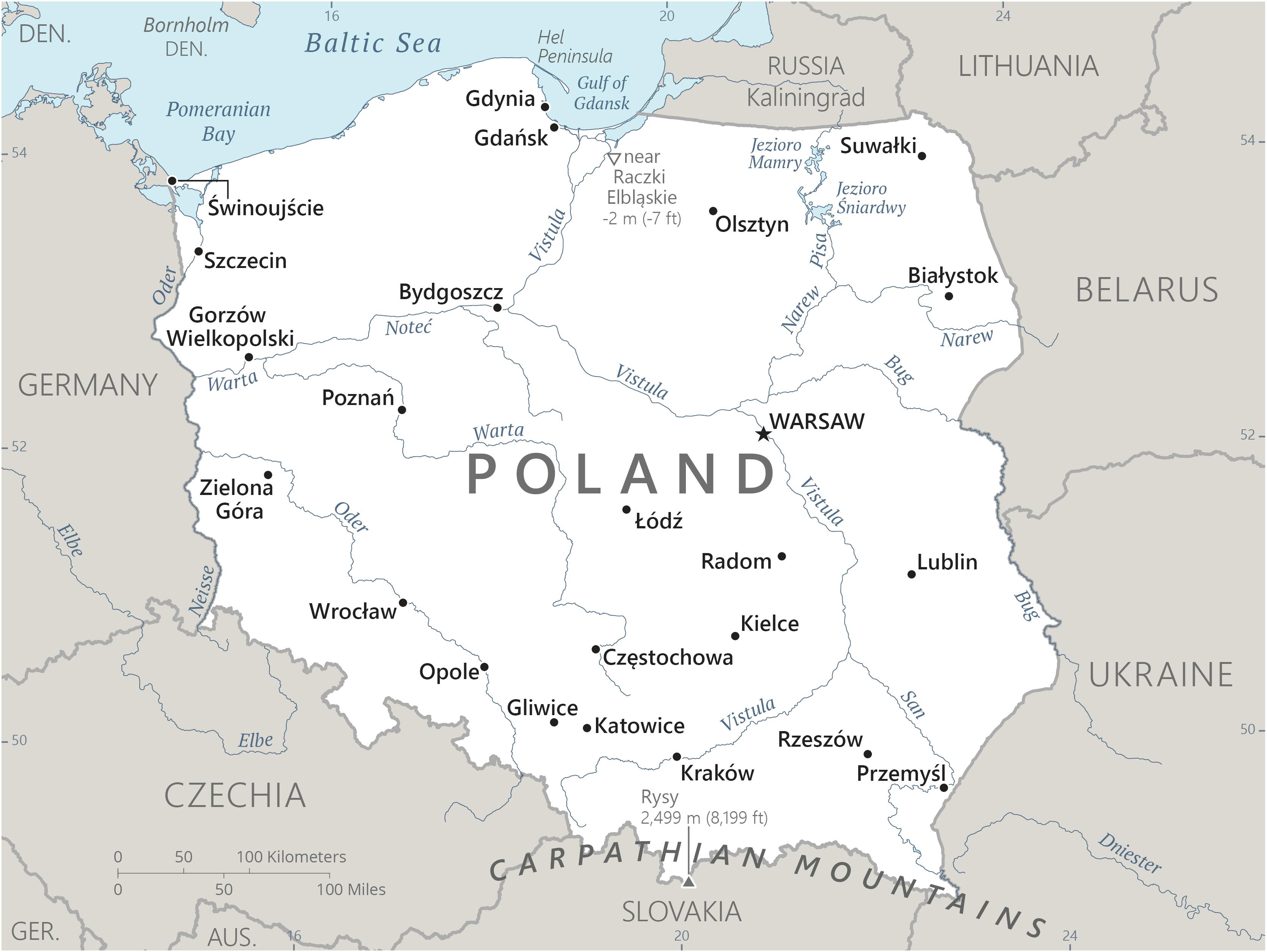
Poland is a country with a rich history, diverse landscapes, and a unique geographical position in Central Europe. Understanding its geographical makeup through a map is essential for exploring its cities, regions, and natural wonders. This article provides a comprehensive look at the Map of Polandand what it reveals about the country.
Quick Facts About Poland
- Capital:Warsaw
- Population:Over 38 million (2024 estimate)
- Area:312,696 km² (120,733 sq mi)
- Official Language:Polish
- Currency:Polish złoty (PLN)
- Time Zone:Central European Time (CET, UTC+1), Central European Summer Time (CEST, UTC+2)
- Government:Republic with a parliamentary democracy
- Borders:Poland shares borders with Germany, Czech Republic, Slovakia, Ukraine, Belarus, Lithuania, and Russia.
- Famous Landmark:Wawel Castlein Kraków
- Longest River:Vistula River (1,047 km)
- Highest Mountain:Rysy (2,499 meters)
- UNESCO World Heritage Sites:16
- National Anthem:"Mazurek Dąbrowskiego"
- Famous Foods:Pierogi (dumplings), Kielbasa (sausage), Żurek (sour rye soup)
- Major Industry:Manufacturing, mining, agriculture, and IT
- National Day:May 3 (Constitution Day)
- Famous Person:Marie Curie, Nobel Prize-winning scientist
- Tourist Attraction:Białowieża Forest, one of the last primeval forests in Europe
- Flag:Two horizontal stripes, white on the top and red on the bottom.
- Independence Day:November 11 (celebrates the restoration of Poland’s independence in 1918)
Geographical Overview Of Poland
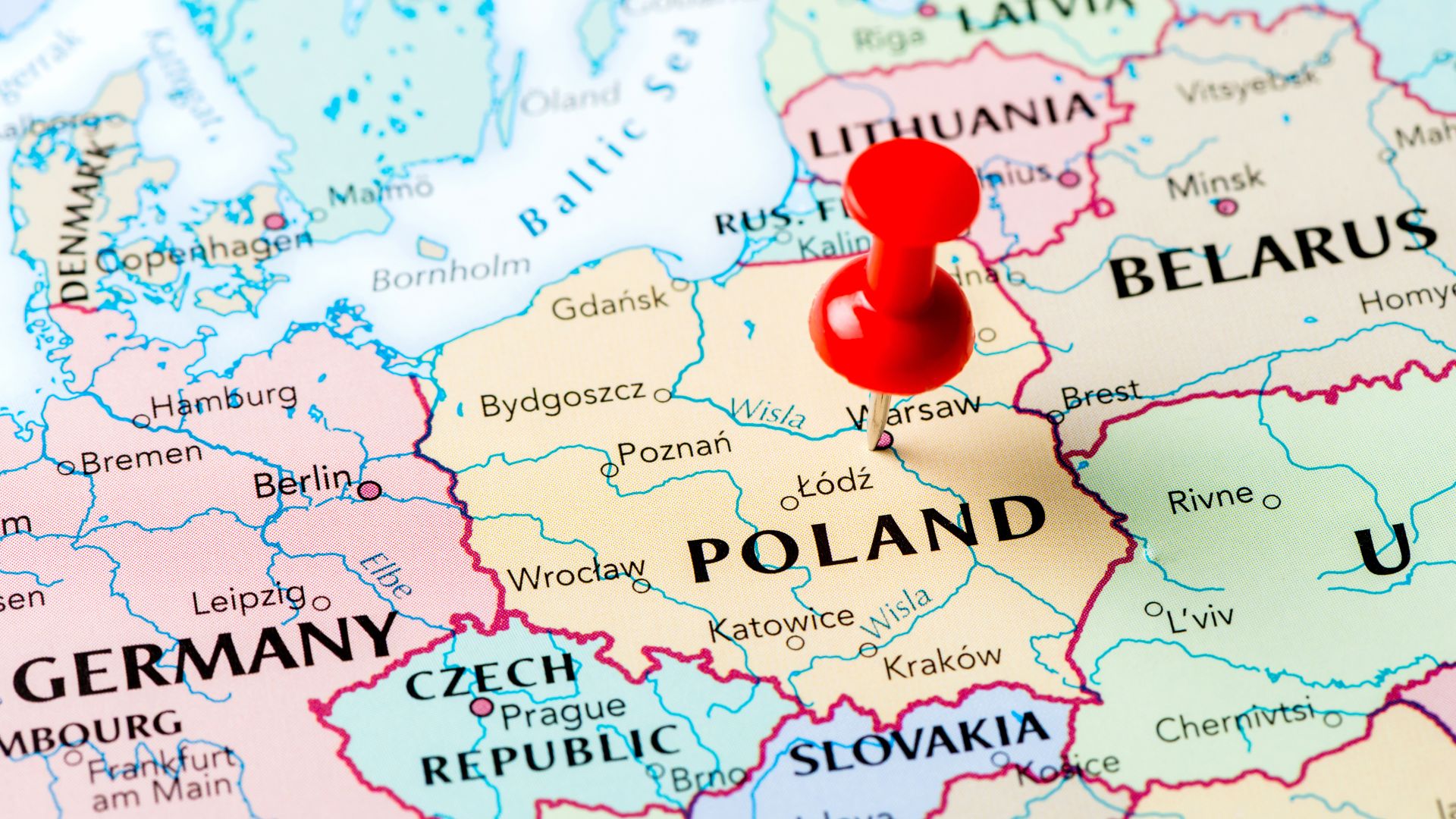
Poland is located in Central Europe, bordered by seven countries: Germany to the west, Czech Republic and Slovakia to the south, Ukraine to the east, Belarus to the northeast, and Lithuania to the north. To the north, Poland also has a coastline along the Baltic Sea.
The country spans an area of over 312,000 square kilometers, making it the ninth-largest country in Europe. Poland’s geography is incredibly diverse, with flat plains in the central and northern parts, rolling hills, and the majestic Tatra Mountains in the south, which form part of the Carpathian range. Poland’s terrain is also dotted with numerous lakes, rivers, and forests, offering a wide variety of natural landscapes.
Capital Of Poland
The capital city of Poland is Warsaw, located in the central part of the country. Warsaw is the political, cultural, and economic center of Poland and is one of the most significant cities in Europe. The city lies on the Vistula River, which divides the city into the Old Town and the New Town.
Warsaw is known for its historic architecture, such as the Royal Castle and the Wilanów Palace, as well as modern landmarks like the Palace of Culture and Science. For those planning European vacations, Warsaw offers a unique blend of historical charm and contemporary appeal, making it a must-see destination.
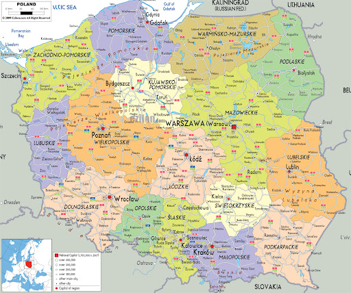
Map Of Poland Cities
1. Warsaw
The capital and largest city of Poland, Warsaw, is a vibrant hub of politics, culture, and commerce. Located on the Vistula River in central Poland, it has a rich history marked by significant events, including its destruction during World War II and its subsequent reconstruction. Warsaw is home to landmarks like the Royal Castle, Lazienki Park, and Palace of Culture and Science. It is a dynamic city known for its thriving arts scene, world-class museums, and as the center of Poland’s government.
2. Kraków
Kraków is one of Poland’s most iconic cities, steeped in history and tradition. Located in southern Poland near the Vistula River, it was the capital of Poland until 1596. The Old Town of Kraków is a UNESCO World Heritage Site, featuring landmarks like Wawel Castle, St. Mary's Basilica, and Rynek Główny (Main Market Square), one of the largest medieval town squares in Europe. Kraków is also a cultural center, known for its universities, art galleries, and music festivals. The nearby Auschwitz-Birkenau memorial and Wieliczka Salt Mine attract millions of visitors each year.
3. Wrocław
Located in southwestern Poland, on the Oder River, Wrocław is known for its picturesque architecture and vibrant cultural scene. Often called the "Venice of Poland," Wrocław has many islands and bridges connecting its charming old town. Its Market Square is one of the most beautiful in the country. Wrocław is also home to the Ostrów Tumski (Cathedral Island), historic Town Hall, and Centennial Hall, a UNESCO World Heritage Site. It’s an important center for trade, education, and culture.
4. Poznań
Poznań is one of the oldest and most historically significant cities in Poland, located in the west-central part of the country. Known for its old market square, Poznań Town Hall, and the Ostrów Tumski cathedral, it is often considered the birthplace of Polish statehood, as it was here that the first Polish rulers were crowned. The city is also a significant economic hub, with a growing tech industry, major trade fairs, and a vibrant cultural calendar. Poznań is home to one of Poland’s top universities, Adam Mickiewicz University.
5. Gdańsk
Situated on the northern coast of Poland along the Baltic Sea, Gdańsk is a historic port city with a rich maritime history. It is known for its beautiful medieval architecture, including the Main Town with its colorful merchant houses, and landmarks like Gdańsk Crane and the Westerplatte Memorial, marking the site of the first battle of World War II. Gdańsk is also part of the Tricity area, together with Gdynia and Sopot, which are known for their modern seafronts and tourism-friendly atmosphere.
6. Łódź
Located in central Poland, Łódź is a city with a rich industrial history that has been undergoing a transformation in recent years. It was once the textile capital of Poland, and remnants of this industrial past can still be seen in its Manufaktura complex, a former factory turned into a massive cultural and commercial center. Today, Łódź is also known for its Piotrkowska Street, one of the longest commercial streets in Europe, and its vibrant film industry, as it is home to Łódź Film School, one of the most prestigious film schools in the country.
7. Kraków
Kraków is one of Poland’s most iconic cities, steeped in history and tradition. Located in southern Poland near the Vistula River, it was the capital of Poland until 1596. The Old Town of Kraków is a UNESCO World Heritage Site, featuring landmarks like Wawel Castle, St. Mary's Basilica, and Rynek Główny (Main Market Square), one of the largest medieval town squares in Europe. Kraków is also a cultural center, known for its universities, art galleries, and music festivals. The nearby Auschwitz-Birkenau memorial and Wieliczka Salt Mine attract millions of visitors each year.
8. Katowice
Located in southern Poland, Katowice is the capital of the Silesian Voivodeship and one of the country’s largest cities. Known for its post-industrial landscape, Katowice was once a coal mining and steel production hub. Today, it has reinvented itself as a cultural and business center, with striking modern architecture such as the Spodek (an iconic arena) and the Silesian Museum. Katowice is also a major site for conferences, exhibitions, and music events, with a thriving artistic community.
9. Szczecin
Szczecin, located in the northwest of Poland on the Oder River near the German border, is an important port city with a rich maritime tradition. It boasts several historic sites, such as Pomeranian Dukes' Castle, the St. James Cathedral, and Wały Chrobrego, an impressive promenade offering panoramic views of the river. Szczecin is also a cultural hub, with theaters, museums, and a strong music scene. Its proximity to the Baltic Sea makes it an important city for trade and commerce.
10. Lublin
Located in eastern Poland, Lublin is one of the country’s oldest cities, with a history dating back to the 10th century. The city is known for its beautifully preserved Old Town, Lublin Castle, and Lublin Cathedral. Lublin has long been a center of Polish-Jewish culture, with a significant Jewish Quarter and a history of multiculturalism. Today, it is a thriving cultural city with a vibrant arts scene, a large student population, and a growing economy focused on education and services.
11. Białystok
Białystok, the capital of the Podlaskie Voivodeship, is located in northeastern Poland, close to the Belarusian border. The city is known for its diverse culture, influenced by Polish, Belarusian, and Russian heritage. Białystok is home to landmarks such as the Branicki Palace, often referred to as the "Polish Versailles," and the Białystok Cathedral. The surrounding area offers vast natural beauty, including the Białowieża Forest, a UNESCO World Heritage Site known for its ancient trees and European bison population.
12. Toruń
Known as the birthplace of Nicolaus Copernicus, Toruń is a medieval gem located in northern Poland along the Vistula River. The city is famous for its well-preserved Old Town, which is a UNESCO World Heritage Site. Toruń's Gothic architecture, including the Toruń Cathedral and Old Market Square, draws visitors year-round. The city is also renowned for its traditional gingerbread, which dates back to the 14th century, and has a lively arts scene centered around its museums and theaters.
13. Rzeszów
Situated in southeastern Poland, Rzeszów is an important economic and academic hub. The city is a major center for Poland’s aviation industry, with Rzeszów Airport serving as a key regional airport. Rzeszów is home to several universities and educational institutions. The Old Town, with its Rzeszów Castle and Market Square, offers a blend of historical and modern influences. The city’s mix of commerce, education, and historical landmarks makes it a growing destination for both tourists and professionals.
14. Gdynia
As part of the Tricity metropolitan area, along with Gdańsk and Sopot, Gdynia is a coastal city on the Baltic Sea. Known for its modernist architecture and maritime history, Gdynia has one of the largest ports in Poland. Visitors can explore the Gdynia Aquarium, ORP Błyskawica (a WWII warship), and enjoy the lively Waterfront area. It is also a cultural hotspot, hosting several international film festivals and music events.
Regions On The Map Of Poland
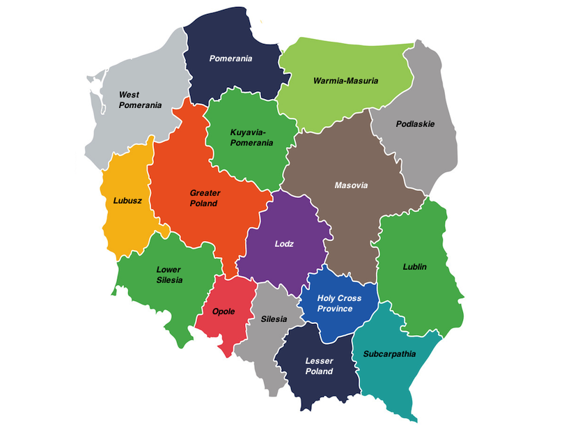
1. Lower Silesian Voivodeship (Dolnośląskie)
Lower Silesia, with its capital in Wrocław, is located in the southwest of Poland. This region is known for its rich history, beautiful architecture, and proximity to the Czech border. Wrocław, the region’s largest city, boasts a stunning market square, historic churches, and numerous islands along the Oder River. The region also features natural beauty, with mountains like the Karkonosze range and numerous forests.
2. Kuyavian-Pomeranian Voivodeship (Kujawsko-Pomorskie)
This central-northern region of Poland includes the city of Bydgoszcz and the historical city of Toruń, famous for its medieval architecture and gingerbread. The Kuyavian-Pomeranian Voivodeship is located on the Vistula River and is characterized by plains and fertile land, making it a significant area for agriculture. The region is also known for its lakes and nature reserves.
3. Lublin Voivodeship (Lubelskie)
Located in the east of Poland, Lublin Voivodeship is a blend of cultural history and natural beauty. Lublin, the capital, is known for its old town, which is one of the best-preserved in Poland. The region has many medieval castles, including Kazimierz Dolny and Zamość, a UNESCO World Heritage site. The area is also rich in forests and parks, making it ideal for nature lovers.
4. Lubusz Voivodeship (Lubuskie)
Lubusz is one of the less populous regions of Poland, located in the western part of the country. The region is bordered by Germany to the west and is rich in forests and lakes. Gorzów Wielkopolski and Zielona Góra are the major cities, with Zielona Góra known for its wine-growing traditions. Lubusz is often regarded for its peaceful landscapes and historical castles, including Żórawki Castle.
5. Łódź Voivodeship (Łódzkie)
Situated in central Poland, Łódź Voivodeship is home to the city of Łódź, which was historically an industrial hub, especially for textiles. The region has a long history of urbanization, and while much of it is now modernized, it still retains its industrial charm. Piotrków Trybunalski, another important city in the region, was once Poland’s medieval capital. The region also features lakes and parks, making it a great place for outdoor activities.
6. Lesser Poland Voivodeship (Małopolskie)
Lesser Poland, or Małopolskie, is one of the most historically significant regions in Poland. The city of Kraków, the capital of the region, was the historical capital of Poland and remains one of the country’s cultural and academic centers. The region is home to the Wieliczka Salt Mine, Auschwitz-Birkenau Memorial, and the Tatra Mountains, Poland’s highest range. This area is known for its medieval towns, castles, and breathtaking mountain landscapes.
7. Masovian Voivodeship (Mazowieckie)
The Masovian Voivodeship, or Mazowieckie, is the largest and most populous region in Poland, with Warsaw as its capital. Warsaw, the capital city of Poland, is an economic, cultural, and political powerhouse, home to many historical sites, museums, and theaters. The region is rich in agriculture, with fertile plains and extensive forestry. Masovia also contains several picturesque towns, such as Pułtusk, known for its beautiful market square.
8. Opole Voivodeship (Opolskie)
Located in the southwestern corner of Poland, Opole Voivodeship is known for its rich cultural heritage and strong ties to German history. Opole, the regional capital, is often called the "Capital of Polish Song" due to its long-standing tradition of the National Festival of Polish Song. The region features charming towns, vineyards, and numerous natural parks, making it a great destination for both history buffs and nature enthusiasts.
9. Podkarpackie Voivodeship (Podkarpackie)
In southeastern Poland, Podkarpackie is a region characterized by its rugged terrain and stunning landscapes, including the Bieszczady Mountains. The capital, Rzeszów, is a thriving university city, but much of the region remains rural and untouched by urban sprawl. It is a great area for hiking, wildlife watching, and experiencing traditional Polish folk culture.
10. Podlaskie Voivodeship (Podlaskie)
Located in the northeast of Poland, Podlaskie Voivodeship is known for its vast natural reserves, including the Białowieża Forest, one of the last and largest remaining parts of the primeval forest that once stretched across Europe. The capital city, Białystok, is a cultural melting pot, with a strong presence of Polish, Belarusian, and Ukrainian communities. The region is rich in biodiversity and has a calm, rural feel.
11. Pomeranian Voivodeship (Pomorskie)
Pomerania, or Pomorskie, is a coastal region located in the north of Poland. The regional capital, Gdańsk, is a historic port city known for its role in World War II and its striking Gothic and medieval architecture. The region is characterized by sandy beaches, coastal dunes, and several islands, including Hel Peninsula and Wolin Island. The Pomeranian Voivodeship also has a strong maritime heritage and numerous seaside resorts.
12. Silesian Voivodeship (Śląskie)
Located in the southern part of Poland, Silesia, or Śląskie, is an industrial powerhouse, known for its heavy industries, including coal mining, steel production, and manufacturing. The capital city, Katowice, is one of Poland’s largest urban centers. The region is also home to stunning natural areas, such as the Silesian Beskids and the Ojcowski National Park. Silesia’s unique mix of industrial strength and natural beauty makes it a fascinating region.
13. Subcarpathian Voivodeship (Świętokrzyskie)
The Subcarpathian Voivodeship, or Świętokrzyskie, is a rural and mountainous region in central Poland. The capital city, Kielce, is known for its historical significance and nearby Świętokrzyskie Mountains, one of the oldest mountain ranges in Europe. The region is dotted with medieval castles, including Chęciny Castle, and is famous for its mineral deposits and natural wonders.
14. Warmian-Masurian Voivodeship (Warmińsko-Mazurskie)
Known for its stunning lakes and forests, Warmian-Masurian is located in northeastern Poland. It is often referred to as the "Land of a Thousand Lakes," with areas like the Masurian Lake District being a major tourist destination. The capital city, Olsztyn, serves as a hub for both agriculture and tourism. This region is known for its tranquil environment, perfect for water sports and outdoor activities.
15. Greater Poland Voivodeship (Wielkopolskie)
Greater Poland, or Wielkopolskie, is located in the west-central part of the country. The region’s capital, Poznań, is one of Poland’s oldest cities, with a rich history dating back to the medieval period. Wielkopolska is known for its agricultural richness, including vast farmlands and forests. The region is also home to the Wielkopolska National Park, and the town of Gniezno, which was Poland’s first capital.
16. West Pomeranian Voivodeship (Zachodniopomorskie)
West Pomeranian, or Zachodniopomorskie, lies in the northwest of Poland, along the Baltic Sea. Szczecin, the region’s capital, is an important port city with a rich maritime history. This region is characterized by its coastlines, islands, and coastal resorts, as well as its dense forests. It’s a great place for those looking to explore Poland's maritime heritage or simply relax on the Baltic beaches.
Population Of Poland
Poland has a population of approximately 38 million people, making it the sixth-most populous country in Europe. The population density is highest in urban areas, particularly in Warsaw, Kraków, and Łódź. On the map, areas with higher population density are marked, which typically correspond to the country's major cities and industrial zones.
The distribution of people across the country is relatively even, but large concentrations of people are found in central Poland, particularly in the capital city region, and in the industrialized areas of the southwest.
Currency Of Poland
The currency used in Poland is the złoty(PLN). The złoty is subdivided into 100 groszy and is symbolized as “zł.” On maps, the currency is not typically marked, but understanding the currency is essential for travelers. The złoty has a rich history, dating back to the 14th century. Currency exchange can be done at banks, exchange offices, or ATMs throughout Poland.
Dialing Code Of Poland
Poland’s international dialing code is +48. This is important for anyone planning to make calls to or from Poland. Whether you’re using a map to navigate to specific cities or regions, the dialing code remains consistent across the country. It’s also worth noting that Poland’s telephone network is well-developed, and major cities are covered by a strong cellular signal.
Language Of Poland
Poland’s official language is Polish, a Slavic language written in the Latin alphabet. It is the mother tongue of nearly all Polish citizens, and is spoken throughout the country. Regional dialects exist, especially in the southern and eastern parts of the country, but standard Polish is widely understood.
On maps, you may see symbols or indicators for bilingual regions where minority languages, like Kashubian or Silesian, are spoken alongside Polish. Poland’s rich cultural heritage also contributes to its vibrant European festivals, where traditions, music, and local customs come together in celebrations that attract visitors from across the continent.
Flag Of Poland
The flag of Poland consists of two horizontal stripes: white on the top and red on the bottom. The flag represents Poland’s struggle for independence and unity, with white symbolizing peace and hope, and red symbolizing the fight for freedom. The flag is proudly displayed on official maps and during national holidays, representing Polish pride and heritage.
Government Of Poland
Poland operates as a parliamentary republic, with a president as the head of state and a prime minister as the head of government. The government structure is decentralized, with 16 voivodeships (regions) each having their own local administration.
On the map, government centers like Warsaw and Kraków are typically highlighted as the major administrative areas, where central and regional governments conduct their work. Poland's political divisions help to organize the country’s legislative and executive functions.
Total Area Of Poland
Poland covers an area of 312,696 square kilometers, making it the ninth-largest country in Europe. The total area includes forests, lakes, and rivers, which cover about 30% of the land. On a map, the total size and shape of Poland are clearly outlined, with its borders drawn to show the extent of its territory, which is located centrally in Europe.
Types Of Poland Map
1. Political Map Of Poland
- Shows national borders.
- Indicates capital cities (Warsaw) and other large cities (Kraków, Gdańsk, Wrocław).
- Marks major roads and highways.
- May include neighboring countries like Germany, the Czech Republic, Slovakia, Ukraine, and others.
- Purpose: Displays the political boundaries of Poland, showing its 16 voivodeships (provinces), major cities, and administrative divisions.
2. Administrative Map Of Poland
- Highlights voivodeship boundaries.
- Provides information about local governance structures.
- May indicate bilingual regions where minority languages are spoken (e.g., Kashubian).
- Purpose: Illustrates Poland’s internal administrative divisions, focusing on voivodeships, counties (powiats), and municipalities (gminas).
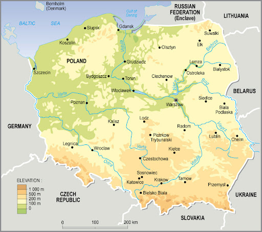
3. Physical Map Of Poland
- Shows Poland’s physical landscape, including the Carpathian and Sudeten Mountains.
- Highlights the Vistula River, Oder River, and other significant waterways.
- Depicts national parks, forests, and protected areas.
- Provides relief by showing elevation changes (e.g., hillshading).
- Purpose: Displays the country’s natural features, including its mountains, rivers, lakes, and forests.
4. Topographic Map Of Poland
- Shows mountain ranges, valleys, and rivers in detail.
- Focuses on landforms and terrain features, like forested areas, hills, and plains.
- Used for activities such as hiking, land-use planning, and geographical study.
- Purpose: A more detailed version of the physical map, showing contour lines to indicate the elevation of the land.
5. Road Map Of Poland
- Highlights major roads like the A1 and A4 highways.
- Shows cities and towns connected by highways.
- Includes rail routes and bus networks for travelers.
- Can also indicate tolls, fuel stations, and rest areas.
- Purpose: Focuses on Poland’s transportation network, including highways, main roads, and rail lines.
6. Tourist Map Of Poland
- Highlights tourist spots like Wieliczka Salt Mine, Auschwitz, and Tatra National Park.
- Includes details on accommodation, restaurants, and public transport.
- Often includes language tips, currency exchange, and other traveladvice.
- Purpose: Designed for travelers to highlight popular tourist destinations, landmarks, historical sites, national parks, and cultural attractions.
- Features:
7. Climate Map Of Poland
- Shows temperature and precipitation patterns.
- Depicts climate zones such as temperate oceanic and continental.
- Used by meteorologists and tourists planning to visit during certain seasons.
- Purpose: Shows the climate zones of Poland, indicating the variation in weather conditions across different regions.
8. Economic Map Of Poland
- Highlights economic hubs like Silesia for coal and steel, Lublin for agriculture, and Gdańsk for shipping.
- Shows natural resources like coal, natural gas, and forests.
- Includes industrial areas and energy infrastructure.
- Purpose: Focuses on Poland’s economic regions, showing areas of industrial production, agriculture, and mining.
9. Historical Map Of Poland
- Shows former Polish territories that were once part of the Commonwealth.
- Highlights historical borders, such as those before WWII or the Treaty of Versailles.
- Useful for understanding Poland's political history.
- Purpose: Displays Poland’s historical boundaries and territories, especially changes over time, like the partitioning of Poland in the late 18th century or post-WWII territorial shifts.
10. Cultural Map Of Poland
- Highlights distinctive cultural areas, such as Masovia, Silesia, or Podhale.
- Includes details on folk art, festivals, customs, and historical architecture.
- Focuses on ethnic diversity and important cultural landmarks.
- Purpose: Focuses on the country’s cultural regions, heritage, and traditions.
11. Religious Map Of Poland
- Indicates the dominance of Roman Catholicism, as well as regions with significant Protestant, Orthodox, or Jewish communities.
- Marks places of religious significance, such as Catholic pilgrimage sites like Czestochowa and Gniezno.
- Purpose: Depicts the distribution of religions in Poland, emphasizing Catholicism, as well as smaller minority faiths.
12. Language Map Of Poland
- Shows the prevalence of Polish (official language) across the country.
- Marks regions where other languages like Kashubian, Silesian, or German are spoken.
- Highlights bilingual areas, particularly in border regions.
- Purpose: Illustrates the distribution of languages spoken across Poland, including minority languages.
13. Biodiversity Map Of Poland
- Highlights national parks, biosphere reserves, and nature reserves.
- Includes information on endangered species, flora diversity, and habitats.
- Purpose: Focuses on the country’s flora and fauna, showing areas of biodiversity, protected nature zones, and the presence of endangered species.
Poland’s Borders And Neighboring Countries
Poland shares its borders with Germany, Czech Republic, Slovakia, Ukraine, Belarus, Lithuania, and Russia. These borders are important not only for trade but also for cultural exchanges. Poland’s position at the crossroads of Europe makes it an integral part of European geopolitics.
Maps of Poland prominently feature these borders, with each neighboring country represented by different colors or lines to signify national boundaries.
National Parks And Landscapes
1. Białowieża National Park
Located on the border with Belarus, Białowieża National Park is one of the last and largest remaining parts of the primeval forest that once covered much of Europe. The park is a UNESCO World Heritage Site and is famous for its ancient trees, including towering oaks, pines, and spruces, some of which are over 500 years old.
2. Tatra National Park
Tatra National Park (Tatrzański Park Narodowy) is located in the Tatra Mountains in southern Poland, along the border with Slovakia. It is the only national park in Poland located within a mountain range and is renowned for its spectacular alpine scenery, including towering peaks, crystal-clear lakes, and dense forests.
3. Bieszczady National Park
Situated in the southeastern corner of Poland, Bieszczady National Park is known for its wild, untamed landscape. The park is characterized by vast, rolling hills, forests, and clear streams. It is one of the most remote and less-visited parks in Poland, making it an ideal location for those seeking solitude and tranquility.
4. Karkonosze National Park
Located in the Karkonosze Mountains in southwestern Poland, Karkonosze National Park is famous for its unique rock formations, glacial valleys, and alpine meadows. The park is a popular destination for hiking, with several trails leading to Śnieżka, the highest peak in the Czech-Polish border region. Visitors can also enjoy skiing in the winter months, making it a year-round destination.
5. Wigry National Park
Located in northeastern Poland, Wigry National Park is centered around the beautiful Wigry Lake and its surrounding wetlands. The park is part of the Masurian Lake District and is known for its scenic beauty and biodiversity. The area features dense forests, tranquil lakes, and rich birdlife, making it a popular spot for birdwatching and kayaking.
6. Pieniny National Park
Pieniny National Park is located in the southern part of Poland, near the borders with Slovakia. It is famous for its Pieniny Mountains and the stunning Dunajec River Gorge, a popular spot for rafting and canoeing. The park’s landscape is characterized by dramatic limestone peaks, lush forests, and pristine rivers. The area is rich in history and folklore, and it is one of Poland’s most picturesque national parks.
7. Masurian Lake District (Masurian Landscape Park)
The Masurian Lake District is one of Poland's most beloved regions, known for its extensive network of over 2,000 lakes spread across a lush, forested landscape. While the Masurian Landscape Park is not a national park, it is still a protected area. The lakes and surrounding woodlands are a haven for outdoor enthusiasts who enjoy sailing, kayaking, cycling, and fishing.
8. Ojcowski National Park
Located in southern Poland near Kraków, Ojcowski National Park is the smallest national park in the country but one of the most charming. The park is known for its striking limestone rock formations, caves, and medieval castles, including the famous Ojców Castle and Pieskowa Skała Castle. The park's landscape is dotted with lush forests, deep ravines, and picturesque streams.
9. Kampinos National Park
Situated just outside of Warsaw, Kampinos National Park is a unique landscape characterized by sand dunes, wetlands, and forests. The park is part of the Vistula River floodplain and is one of the largest protected areas in Poland. It’s a vital sanctuary for numerous species of animals, including the European bison, wild boar, and deer.
10. Drawa National Park
Located in western Poland, Drawa National Park is known for its pristine river landscapes, forests, and lakes. The park is named after the Drawa River, which flows through the area, creating a stunning natural landscape ideal for kayaking, canoeing, and hiking.
11. Słowiński National Park
Located on the Baltic Sea coast in northern Poland, Słowiński National Park is renowned for its shifting sand dunes, which are among the largest in Europe. The park also includes peat bogs, lakes, and coastal meadows. The shifting dunes are a unique landscape feature, as they constantly change shape due to wind.
12. Świętokrzyski National Park
Located in central Poland, Świętokrzyski National Park is known for its ancient Świętokrzyskie Mountains and lush, dense forests. The park is named after the Holy Cross Mountain, which is home to a centuries-old monastery. The area is rich in geological history, with notable sites such as the Łysica Peak, the highest point in the range.
Poland’s Natural Wonders On The Map
1. Białowieża Forest
Location: Border with Belarus
Description: Białowieża Forest is one of Europe’s last and largest remaining primeval forests. It’s a UNESCO World Heritage Site, home to ancient trees, wildlife, and European bison. The forest’s towering oaks, pines, and spruces offer a glimpse into what Europe’s forests once looked like before human intervention. It is an exceptional place for hiking and wildlife watching.
2. Tatra Mountains
Location: Southern Poland (near Slovakia)
Description: The Tatra Mountains form part of the Carpathian range and are the highest mountains in Poland. They are famous for their rugged peaks, deep valleys, crystal-clear lakes, and a vast network of hiking trails. The Tatra National Park is home to rare flora and fauna and offers activities ranging from hiking to skiing, making it a year-round destination.
3. Masurian Lake District
Location: Northeastern Poland
Description: Known as the “Land of a Thousand Lakes,” the Masurian Lake District is a peaceful and picturesque region filled with more than 2,000 lakes. This area is perfect for water sports such as sailing, kayaking, and fishing. The landscape is dotted with forests, marshes, and charming towns, making it an idyllic destination for nature lovers.
4. Bieszczady Mountains
Location: Southeastern Poland
Description: The Bieszczady Mountains are one of Poland's wildest and least explored regions, known for their untouched natural beauty. Characterized by rolling hills, dense forests, and dramatic rivers, this region offers a sense of isolation that’s hard to find elsewhere. It’s also home to rare wildlife like the European bison and the lynx, and is a popular spot for hiking, birdwatching, and stargazing.
5. Pieniny National Park And Dunajec River Gorge
Location: Southern Poland (near Slovakia)
Description: The Dunajec River Gorge in Pieniny National Park is a stunning natural wonder, with steep limestone cliffs towering over the river. It is famous for its raft trips, where visitors can float down the river, surrounded by majestic landscapes. The region’s unique rock formations, including the Three Crowns Peak, make it a popular destination for nature enthusiasts and photographers.
6. Słowiński Sand Dunes
Location: Northern Poland (Baltic Sea coast)
Description: The Słowiński Sand Dunes are one of Poland’s most unique landscapes, where large, shifting dunes are constantly reshaped by wind. Located in Słowiński National Park, these dunes can reach up to 30 meters in height and stretch along the Baltic coastline. Visitors can walk or cycle through the dunes, which also provide views of the sea and surrounding wetlands. This area is a haven for birdwatching and offers one of Poland's most distinctive coastal experiences.
7. Wrocław’s Oder River Islands
Location: Wrocław (Central Poland)
Description: The Oder River Islands in Wrocław offer a unique blend of urban nature. These islands are lush with greenery, and several parks and gardens are spread across the islands. The region is famous for its picturesque views, wildlife, and historical architecture, blending nature with culture in one of Poland's most vibrant cities.
8. Wieliczka Salt Mine
Location: Southern Poland (near Kraków)
Description: The Wieliczka Salt Mine is an extraordinary underground world that stretches for miles. The mine, which has been in operation for over 700 years, is a UNESCO World Heritage Site and features intricate tunnels, chambers, and chapels carved out of salt. The mine also has its own underground lake and provides visitors with a unique glimpse into Poland's industrial heritage while showcasing geological wonders.
9. The Vistula Spit
Location: Northern Poland (on the Baltic Sea)
Description: The Vistula Spit is a long, narrow peninsula that stretches into the Baltic Sea, creating a stunning natural landscape. It is home to diverse ecosystems, including sandy beaches, dunes, and marshlands. The area is a key bird migration route and part of the Vistula Lagoon, offering great opportunities for birdwatching, kayaking, and hiking.
10. Zakrzówek Lake
Location: Near Kraków, Southern Poland
Description: Zakrzówek Lake is a hidden gem, a picturesque blue lake nestled in a limestone quarry. The lake's waters are incredibly clear, surrounded by steep cliffs that give the area a stunning, almost surreal appearance. It has become a popular spot for diving, as well as hiking and nature walks, offering a peaceful escape just outside of Kraków.
11. Karkonosze Waterfalls
Location: Karkonosze Mountains, Southwestern Poland
Description: The Karkonosze Waterfalls, especially the Kamieńczyk Falls and Szklarka Falls, are among the most beautiful in Poland. The falls cascade through the dense forested valleys of the Karkonosze Mountains, offering a serene environment for visitors. These waterfalls are particularly enchanting in the spring and summer when the surrounding flora is in full bloom.
12. Tuchola Forest
Location: Northern Poland
Description: The Tuchola Forest is part of the Tuchola Landscape Park and is one of Poland’s largest forested areas. The region features dense pine forests, rivers, lakes, and bogs, making it a paradise for hikers, bikers, and nature lovers. The area is also a great destination for birdwatching, with many rare species found in its protected environment.
13. The Rospuda Valley
Location: Northeastern Poland
Description: The Rospuda Valley is known for its pristine wetlands, rivers, and rich biodiversity. It is part of the Rospuda River Basin and provides an essential habitat for migratory birds and other wildlife. The valley is surrounded by lush forests and is a perfect place for nature enthusiasts interested in observing Poland’s untouched landscapes.
14. Łódź Forests (Łódź Region)
Location: Central Poland
Description: The Łódź Forests are an extensive area of mixed forests that cover much of the Łódź Region. These forests are rich in flora and fauna, making them a perfect place for hiking and exploring. They also provide a habitat for rare species of plants and animals, such as woodpeckers and deer.
Major Roads And Transportation
1. A1 Highway (Autostrada A1)
Route: From Gdańsk (North) to Świerklany (South)
Description: The A1 Highway is one of Poland's most important and longest highways, stretching from the Baltic Sea in the north to the southern border with the Czech Republic. It connects major cities like Gdańsk, Toruń, Łódź, and Katowice, and is a key route for both domestic and international traffic. The A1 is integral for facilitating trade, tourism, and regional development, and is often used by travelers heading towards the Czech Republic and Slovakia.
2. A2 Highway (Autostrada A2)
Route: From Świecko (West) to Terespol (East)
Description: The A2 Highway runs across Poland from the western border with Germany at Świecko to the eastern border with Belarus at Terespol. It is one of the main corridors for international traffic, particularly for travelers heading toward Berlin, Warsaw, and beyond to Minsk and Moscow. The highway facilitates the transport of goods and passengers and connects major urban centers, including Poznań, Warsaw, and Łódź. The A2 is considered a key route for Poland’s integration with the European Union.
3. A4 Highway (Autostrada A4)
Route: From Zgorzelec (West) to Korczowa (East)
Description: The A4 Highway runs from the western border with Germany at Zgorzelec to the eastern border with Ukraine at Korczowa. It passes through Wrocław, Kraków, and Rzeszów, making it a crucial route for travelers and freight transport. The A4 serves as a vital connection between Poland and Germany, as well as between Poland and Ukraine. It is an essential road for commercial transport and cross-border travel, especially for those traveling toward the Eastern European markets.
4. S3 Expressway (Droga Ekspresowa S3)
Route: From Świnoujście (North) to Lubawka (South)
Description: The S3 Expressway runs from the northern port city of Świnoujście, near the Baltic Sea, to Lubawka on the southern border with the Czech Republic. This expressway is a major route for traveling through the Lubusz and Lower Silesian regions and is a key link for international travel between Poland and Czech Republic. The S3 is a modern, fast route connecting several important cities, including Zielona Góra and Legnica.
5. S7 Expressway (Droga Ekspresowa S7)
Route: From Gdańsk (North) to Rabka-Zdrój (South)
Description: The S7 Expressway connects the northern port city of Gdańsk with the southern mountainous town of Rabka-Zdrój, running through Warsaw and Kielce. The S7 is a critical route for domestic travel, providing a fast and efficient way to travel between Poland’s two largest cities, Warsaw and Kraków. It is also a key route for tourists heading to the Tatra Mountains and Zakopane.
6. S8 Expressway (Droga Ekspresowa S8)
Route: From Wrocław (West) to Białystok (East)
Description: The S8 Expressway runs from Wrocław in the west to Białystok in the northeast, passing through Łódź and Warsaw along the way. It is a vital route that connects several major cities and regions, facilitating the movement of goods and people across the country. The S8 also provides an important link between Poland and neighboring Lithuania, making it a crucial international route.
7. S5 Expressway (Droga Ekspresowa S5)
Route: From Wrocław (Southwest) to Gniezno (Northwest)
Description: The S5 Expressway runs from Wrocław to Gniezno, cutting through central Poland. It is a major north-south route that links the Wrocław area with Poznań and Bydgoszcz, providing access to Poland’s agricultural and industrial centers. This expressway is particularly useful for travelers moving between the Greater Poland and Lower Silesia regions.
8. S19 Expressway (Droga Ekspresowa S19)
Route: From Rzeszów (South) to Lublin (North)
Description: The S19 Expressway runs from the southern region of Rzeszów to Lublin in the north. It is part of the European road network, connecting central and eastern Poland and providing a faster alternative for traffic moving between Lviv (Ukraine) and Warsaw. This expressway is essential for regional connectivity in Poland’s eastern regions.
9. E30 Road (European Route E30)
Route: From Świecko (West) to Terespol (East)
Description: The E30 is a pan-European road that traverses Poland from Świecko on the German border to Terespol on the Belarusian border. It is part of the larger European route network, connecting cities like Poznań, Warsaw, and Lublin. The E30 provides key international links for both passenger and freight transport, especially for travelers heading from Western Europe to Eastern Europe.
10. E65 Road (European Route E65)
Route: From Gdańsk (North) to Zakopane (South)
Description: The E65 is an important north-south route that runs from Gdańsk in the north, passing through Warsaw and Kraków, and reaching Zakopane in the south. It connects major tourist destinations such as Kraków and Zakopane and provides access to the Tatra Mountains. This European route is a popular choice for travelers heading to the Carpathian region or enjoying a scenic journey through Poland.
Climate Map
Poland has a temperate climate with distinct seasons. The climate varies from oceanic in the west to continental in the east. Maps often feature climate zones to show how temperatures, precipitation, and weather conditions differ throughout the country.
Poland’s Economy
Poland has a diverse economy, driven by industries such as manufacturing, agriculture, and services. Major economic regions, such as Silesia for coal mining and Mazovia for services and finance, are marked on economic maps. Poland’s economic landscape plays a vital role in its global position.
How To Use A Map Of Poland For Travel
A map of Poland is an invaluable tool for travelers looking to explore the country’s historical cities, beautiful landscapes, and cultural attractions. Using both physical and digital maps, you can plan your journey, identify points of interest, and navigate through Poland’s road network efficiently.
For those planning to visit during European festivals july, a map can also help you find key festival locations and events, ensuring you don’t miss out on the exciting summer celebrations happening across the country.
10 Interesting Facts About Poland
1. Poland Is Home To The Oldest Operating Restaurant In Europe
In the heart of Kraków, you’ll find Starka Restaurant, which dates back to 1792. This makes it the oldest continuously operating restaurant in Europe. It serves traditional Polish dishes in a historic setting, offering a taste of Poland's long-standing culinary heritage.
2. Poland Has 16 Administrative Regions
Poland is divided into 16 voivodeships or regions. Each of these regions has its own unique cultural identity and history. From the picturesque landscapes of Podhale to the bustling metropolis of Warsaw, Poland’s regions offer a diverse experience for residents and travelers alike.
3. The Wawel Dragon Is A Legend Of Kraków
One of Poland’s most famous legends involves the Wawel Dragon, said to have lived near Wawel Castle in Kraków. According to the tale, the dragon terrorized the city until a clever cobbler tricked it into eating a poisoned sheep. The dragon then exploded, marking the end of its reign of terror. Today, a statue of the dragon stands at the foot of Wawel Hill, shooting fire from its mouth as a tribute to the legend.
4. Poland Is Known For Its Stunning Castles
Poland boasts over 500 castles scattered throughout the country, many of which are architectural masterpieces. Malbork Castle, the largest brick castle in the world, and Wawel Castle are among the most famous. These historic fortresses tell the story of Poland's turbulent and glorious past.
5. The Białowieża Forest Is One Of Europe’s Last Primeval Forests
Located on the border between Poland and Belarus, the Białowieża Forest is one of Europe’s last and largest remaining primeval forests. It’s home to the endangered European bison and is a UNESCO World Heritage Site. Visitors can explore the untouched wilderness and spot rare wildlife.
6. The Vistula River Is Poland’s Longest River
The Vistula River is the longest river in Poland, stretching over 1,000 kilometers. It flows from the Carpathian Mountains in the south to the Baltic Sea in the north, passing through major cities like Warsaw and Kraków. The river has played a crucial role in Poland’s history, serving as a key trade route and cultural symbol.
7. Poland Was The First Country To Abolish The Death Penalty
In 1997, Poland became the first country in Eastern Europe to abolish the death penalty. The country’s progressive stance on human rights has been a symbol of its transformation after the fall of communism and its journey toward a democratic society.
8. The Polish Language Has A Rich Vocabulary
The Polish language is a member of the Slavic language family, and it’s known for its complex grammar and unique sounds. It has several regional dialects, and some words in Polish have no direct translation in other languages. For example, the word “żółć” refers to the bitterness of a taste, a concept that doesn’t exist in many languages.
9. Poland Is A World Leader In The Production Of Amber
Poland is one of the world’s largest producers of amber, also known as “Baltic Gold”. The country has been trading amber for thousands of years, and Gdańsk, a port city on the Baltic Sea, is home to the Amber Museum, which showcases the gemstone in its many forms.
10. Poland Has More Than 2,000 Lakes
Poland is home to over 2,000 lakes, many of which are located in the northern part of the country in regions like Masuria and Kaszuby. The Masurian Lake District is particularly popular for its pristine waters, beautiful scenery, and opportunities for water sports, making it a prime destination for nature lovers.
FAQs
What Countries Border Poland?
Poland shares borders with seven countries: Germany, Czech Republic, Slovakia, Ukraine, Belarus, Lithuania, and Russia (Kaliningrad Oblast).
What Are The Major Highways In Poland?
Poland has several key highways, including the A1 (connecting Gdańsk to the Czech border), A2 (running east to west, from Świecko to Terespol), and A4 (linking Wrocław to the Ukrainian border). These highways facilitate travel across the country and connect major cities.
What Are The Major Cities In Poland?
Some of the most important cities in Poland include Warsaw, Kraków, Gdańsk, Wrocław, and Poznań. These cities are major cultural, economic, and historical hubs.
What Are The Natural Wonders Of Poland?
Poland is home to several remarkable natural wonders, including Białowieża Forest (one of the last and largest remaining parts of the primeval forest that once stretched across Europe), the Tatra Mountains, and the Wieliczka Salt Mine, a UNESCO World Heritage Site.
How Can I Use A Map Of Poland For Travel?
A map of Poland is essential for navigating the country’s extensive transportation system, including its highways, railways, and tourist attractions. It helps travelers plan routes, find major landmarks, and explore Poland’s diverse landscapes.
If you're planning routes through Warsaw, Kraków, and Gdańsk, see the travel Poland guidefor practical itineraries, seasonal tips, and typical costs.
Does Poland Have A Good Public Transportation System?
Yes, Poland has an efficient and well-developed public transportation system, including buses, trams, and a comprehensive railway network that connects major cities and regions.
Conclusion
Maps of Poland are more than just navigational tools, they are windows into the country’s history, geography, and culture. If you're planning a trip or studying its diverse regions, understanding the geography of Poland through a map can provide valuable insights into this beautiful Central European country.
Jump to
Quick Facts About Poland
Geographical Overview Of Poland
Capital Of Poland
Map Of Poland Cities
Regions On The Map Of Poland
Population Of Poland
Currency Of Poland
Dialing Code Of Poland
Language Of Poland
Flag Of Poland
Government Of Poland
Total Area Of Poland
Types Of Poland Map
Poland’s Borders And Neighboring Countries
National Parks And Landscapes
Poland’s Natural Wonders On The Map
Major Roads And Transportation
Climate Map
Poland’s Economy
How To Use A Map Of Poland For Travel
10 Interesting Facts About Poland
FAQs
Conclusion

Finn Wilde
Author
For Finn Wilde, the wilderness is more than just a destination - it’s a way of life. Over the past decade, he has led multiple expeditions in some of the world’s most remote regions, from the icy fjords of Greenland to the rugged trails of Patagonia.
Finn emphasizes sustainability in all of his adventures, helping participants connect with nature while promoting responsible exploration. His expeditions inspire individuals to explore the great outdoors while fostering a deep respect for the environment.

Michael Rachal
Reviewer
Michael Rachal believes that luxury lies in the details. With over 20 years of experience in the luxury travel industry, he has crafted hundreds of bespoke itineraries for clients seeking personalized, unforgettable experiences.
Whether guiding clients through private cultural tours or curating culinary journeys with world-renowned chefs, Michael ensures that each trip is tailored to perfection.
His ability to anticipate needs and exceed expectations has earned him a reputation as a leading expert in luxury travel.
Latest Articles
Popular Articles