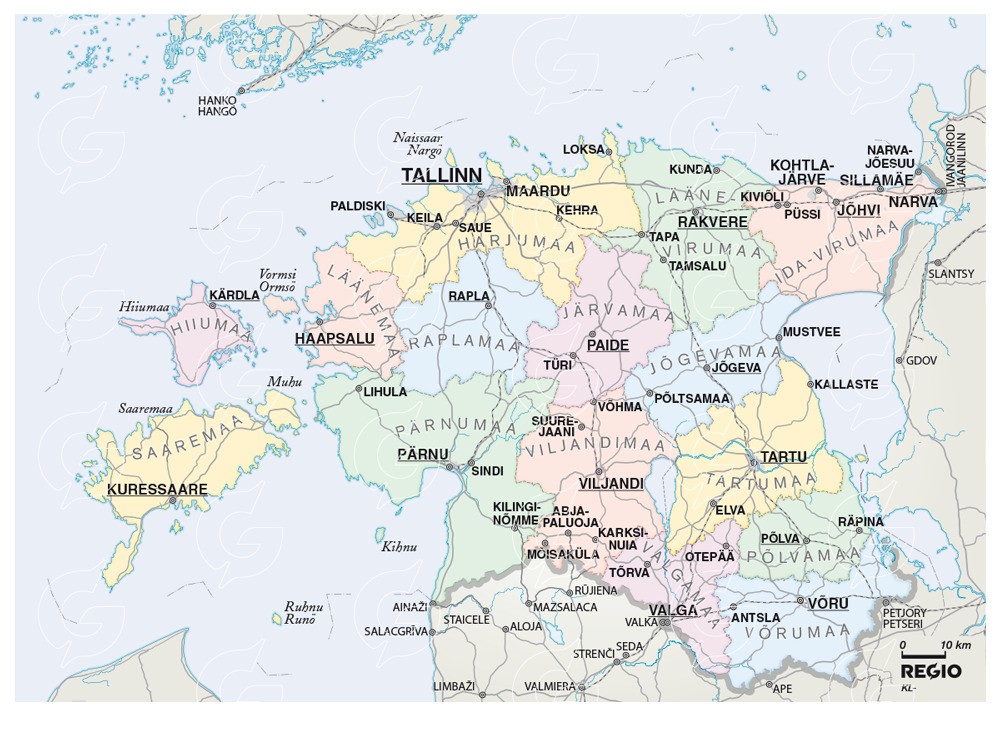
Map Of Estonia - Complete Guide To Borders, Regions, And Attractions
Estonia’s map highlights its most iconic features, including charming regions, pristine nature, and bustling urban hubs.
Author:Michael RachalReviewer:Finn WildeMar 13, 20258.6K Shares261.5K Views
With its breathtaking landscapes, fascinating history, and state-of-the-art technology, Estonia is a hidden jewel in Northern Europe. From its stunning coastline to its verdant forests and quaint medieval villages, Estonia is a small country full of varied scenery.
Due in large part to its location on the Baltic Sea, Estonia has developed a distinctive culture that is affected by its neighbors while retaining its own identity. Examining a map of Estoniaoffers a glimpse into its dynamic cities, stunning natural treasures, and inventive spirit in addition to its geography.
The map of Estonia is your key to unlocking its mysteries, either you're undertaking study, organizing a trip, or are just interested in this intriguing nation.
Quick Facts About Estonia
- Official Name:Republic of Estonia
- Capital:Tallinn
- Population:Approximately 1.3 million
- Area:45,339 square kilometers (17,505 square miles)
- Official Language:Estonian
- Currency:Euro (€)
- Dialing Code:+372
- Government:Parliamentary Republic
- Time Zone:Eastern European Time (EET, UTC +2)
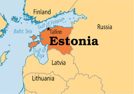
- Borders:Latvia to the south, Russia to the east; bordered by the Baltic Sea to the west and north
- Major Cities:Tallinn, Tartu, Narva, Pärnu
- National Flower:Cornflower
- National Bird:Barn Swallow
- Highest Point:Suur Munamägi (318 meters above sea level)
- UNESCO World Heritage Sites:Tallinn’s Old Town
Overview Of Estonia’s Geography
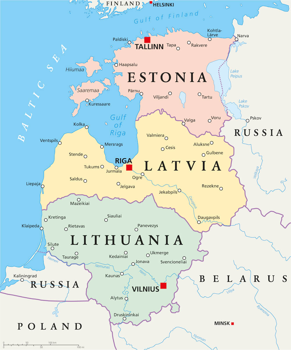
Located in Northern Europe, Estonia shares borders with Russia to the east, Latvia to the south, and the Baltic Sea to the west and north. This prime location has made Estonia a historical crossroads of trade, culture, and power. Despite its relatively small area of 45,227 square kilometers, Estonia boasts over 2,000 islands, a rugged coastline, and lush green landscapes that change dramatically with the seasons.
Estonia's diverse geography includes flat lowlands interspersed with rolling hills, extensive forests that cover nearly half the country, and numerous lakes and rivers. Notably, Lake Peipus, the fifth-largest lake in Europe, marks the border with Russia. For travelers seeking best places to travel on a budget, Estonia offers a perfect blend of affordability, natural beauty, and rich cultural heritage. Its protected nature reserves and scenic landscapes make it an ideal destination for budget-conscious visitors.
Capital Of Estonia
The capital of Estonia is Tallinn, located on the northern coast along the Gulf of Finland, directly across from Helsinki. Tallinn is a city where history and modernity blend seamlessly. Its medieval Old Town, a UNESCO World Heritage Site, is characterized by cobblestone streets, Gothic churches, and ancient city walls. The city is also a thriving hub for technology and innovation, often referred to as the "Silicon Valley of Europe" due to its vibrant startup culture and advanced digital infrastructure.
Map Of Estonia Cities
1. Tallinn
Tallinn is Estonia’s largest city and economic powerhouse. The Old Town, with its medieval charm, draws tourists worldwide, while the city’s modern districts boast high-tech offices, luxury shopping centers, and fine dining. Kadriorg Palace and Park, built by Peter the Great, and the Seaplane Harbour Museum are must-see attractions. Tallinn is also a green city, with numerous parks and seaside promenades offering stunning views of the Baltic Sea.
2. Tartu
Known as the "City of Good Thoughts," Tartu is Estonia's second-largest city and an intellectual hub. It is home to the University of Tartu, one of Northern Europe’s oldest universities, which brings a youthful and dynamic energy to the city. Tartu boasts cultural landmarks such as the Tartu Art Museum, Town Hall Square, and the AHHAA Science Centre, attracting visitors of all ages.
3. Narva
Narva, located on the eastern border with Russia, is rich in historical significance. The iconic Narva Castle, overlooking the Narva River, symbolizes the city’s strategic importance throughout centuries. Despite its war-torn history, Narva is undergoing revitalization, with investments in cultural and urban development projects.
4. Pärnu
Pärnu, Estonia’s summer capital, is synonymous with relaxation. It is famous for its sandy beaches, health spas, and vibrant nightlife. The Pärnu River and the town’s lush parks make it an ideal destination for both adventure and leisure travelers.
5. Kohtla-Järve
Located in the northeastern region, Kohtla-Järve is a center for oil shale mining, which is vital to Estonia’s energy industry. The town also offers unique attractions like the Oil Shale Museum, where visitors can explore the history of mining in the region.
6. Rakvere
Rakvere is a historic town with a modern twist. The Rakvere Castle is a key attraction, hosting medieval reenactments and cultural events. The Tarvas statue, a massive bull sculpture, is another iconic landmark representing the town’s spirit of resilience.
7. Viljandi
This charming town in southern Estonia is well known for its cultural events, especially the Viljandi Folk Music Festival, which takes place every year. Visitors are treated to a lovely setting by the lake and the remains of Viljandi Castle.
8. Haapsalu
Haapsalu is a serene coastal town famous for its wooden architecture and healing mud baths. The Haapsalu Castle and Promenade are major attractions, offering a mix of history and relaxation.
9. Kuressaare
Kuressaare, the capital of Saaremaa Island, serves as a starting point for visiting the largest island in Estonia. Its peaceful surroundings and well-preserved Kuressaare Castle draw both history buffs and environment lovers.
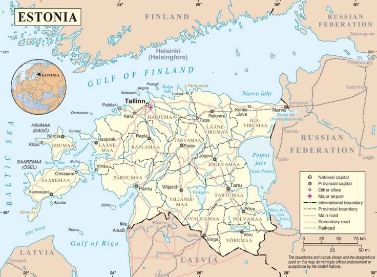
Estonia’s Administrative Divisions
1. Harju County
Harju County, located in northern Estonia, is the most populous and economically significant region in the country. It includes Tallinn, the nation’s capital, which serves as Estonia’s political, cultural, and economic heart. The county features a mix of urban and rural landscapes.
- Tallinn:Known for its medieval Old Town, Tallinn is a UNESCO World Heritage Site, offering a glimpse into Estonia’s rich history. The city is also a tech hub, with numerous startups and modern infrastructure.
- Coastal Beauty:Harju County boasts a stunning coastline along the Gulf of Finland, with sandy beachesand seaside towns such as Viimsi and Laulasmaa.
- Natural Attractions:The region is home to Lahemaa National Park, Estonia’s largest and oldest national park, which features picturesque bogs, forests, and coastal villages.
2. Tartu County
Tartu County is located in southeastern Estonia and is often considered the country’s intellectual and cultural center.
- Tartu City:As Estonia’s second-largest city, Tartu is home to the prestigious University of Tartu, which dates back to 1632. The city has a youthful atmosphere, with vibrant cultural festivals, theaters, and museums.
- Innovation Hub:The region is a center for scientific research and innovation, with many startups emerging from the academic community.
- Natural Beauty:Tartu County features serene rivers such as the Emajõgi, which flows through Tartu City, as well as scenic hiking trails and small villages that showcase traditional Estonian life.
3. Saare County
Saare County is composed of several islands in western Estonia, with Saaremaa being the largest and most well-known.
- Kuressaare:The capital of Saaremaa, Kuressaare, is famous for its well-preserved medieval castle and charming streets.
- Cultural Heritage:Saare County is known for its iconic windmills, traditional farmhouses, and handicrafts that reflect the islanders’ way of life.
- Natural Landscapes:The region features unique landscapes, such as Kaali Crater, a meteorite impact site, and Sõrve Peninsula, known for its lighthouse and birdwatching opportunities.
4. Ida-Viru County
Ida-Viru County, located in northeastern Estonia, is a region of striking contrasts, combining industrial development with breathtaking natural beauty.
- Industrial Centers:Towns like Narva and Kohtla-Järve are important hubs for oil shale mining and energy production.
- Historical Sites:Narva Castle, situated on the border with Russia, is a symbol of the region’s historical and cultural significance.
- Natural Attractions:The region is home to Toila-Oru Park, a beautifully landscaped park near the Baltic Sea, and the Blue Hills (Sinimäed), which are significant for their historical wartime events.
5. Lääne County
Lääne County is situated on the western coast of Estonia and is known for its peaceful environment and abundant natural attractions.
- Haapsalu:This seaside village is well known for its relaxing parade, therapeutic mud baths, and wooden architecture. One of the region's most important historical sites is Haapsalu Castle.
- Matsalu National Park:The park is one of Europe’s most important wetlands, attracting birdwatchers from around the globe. It is a vital habitat for migratory birds, with over 250 species recorded.
- Islets and Coastline:The region includes countless small islands and a picturesque coastline that provides opportunities for kayaking, sailing, and eco-tourism.
6. Pärnu County
Located in southwestern Estonia, Pärnu County is celebrated for its beautiful beaches, spas, and lively summer atmosphere.
- Pärnu City:Known as Estonia’s "summer capital," the city offers a perfect blend of relaxation and entertainment. Visitors can enjoy sandy beaches, waterfront cafes, and luxurious spas.
- Countryside Charm:Beyond the city, the county features quaint villages, lush forests, and serene rivers, making it a great destination for nature lovers.
- Outdoor Activities:Pärnu County is ideal for hiking, cycling, and birdwatching, with several nature trails and protected areas.
7. Võru County
Southern Estonia's Võru County is a charming area known for its beautiful lakes, thick forests, and hills that curve.
- Võru Town:The county’s administrative center is known for its laid-back atmosphere and traditional architecture. It also hosts the Võru Folklore Festival, celebrating local culture and traditions.
- Lake Tamula:Located near Võru Town, this lake is a popular spot for swimming, fishing, and relaxing.
- Natural Wonders:The county includes Haanja Nature Park, which features Suur Munamägi, the highest peak in the Baltic states, offering panoramic views.
8. Lääne-Viru County
Lääne-Viru County is rich in historical and cultural landmarks and is an important agricultural region.
- Rakvere:The town is famous for Rakvere Castle, which hosts medieval-themed events and activities. The Tarvas statue, a large bull sculpture, is another notable attraction.
- Lahemaa National Park:Parts of this renowned park extend into Lääne-Viru County, showcasing diverse landscapes such as forests, rivers, and coastal cliffs.
- Agricultural Traditions:The county is known for its fertile lands and traditional farming practices, which contribute to Estonia’s agricultural economy.
Population Of Estonia
As of 2025, Estonia’s population is approximately 1.3 millionpeople. The population density is low, with most residents living in urban areas like Tallinn and Tartu. Estonia has an aging population, but it also attracts young talent due to its digital-first policies and vibrant job market. Ethnic Estonians make up about 70% of the population, with Russians, Ukrainians, and other minorities comprising the rest.
Currency Of Estonia
The Euro (EUR)has been Estonia’s official currency since 2011. Prior to that, the Estonian kroon was used. The transition to the Euro was a major milestone in the country’s integration into the European Union.
Dialing Code Of Estonia
The dialing code for Estonia is +372. This prefix is used when making international calls to Estonia. To reach an Estonian number from abroad, you would dial the international access code of your country (e.g., 011 in the United States or 00 in most European countries), followed by Estonia’s country code, 372, and then the local phone number.
For example, to call a number in Tallinn (Estonia’s capital) from abroad, you would dial:+372 [local phone number].
Language Of Estonia
The official language is Estonian, a Finno-Ugric language closely related to Finnish. While most young people speak English fluently, Russian remains common among older generations and in the eastern parts of the country.
Total Area Of Estonia
Estonia spans a total area of approximately 45,339 square kilometers (17,505 square miles), making it one of the smaller countries in Europe. With more than 2,000 islands, wetlands, extensive woods, and a coastline that stretches more than 3,800 kilometers along the Baltic Sea, Estonia has a diverse and beautiful environment despite its small size. The country's topography is mostly flat, with hills that turn in the south. Suur Munamägi, at 318 meters (1,043 feet), is the highest point.
Government Of Estonia
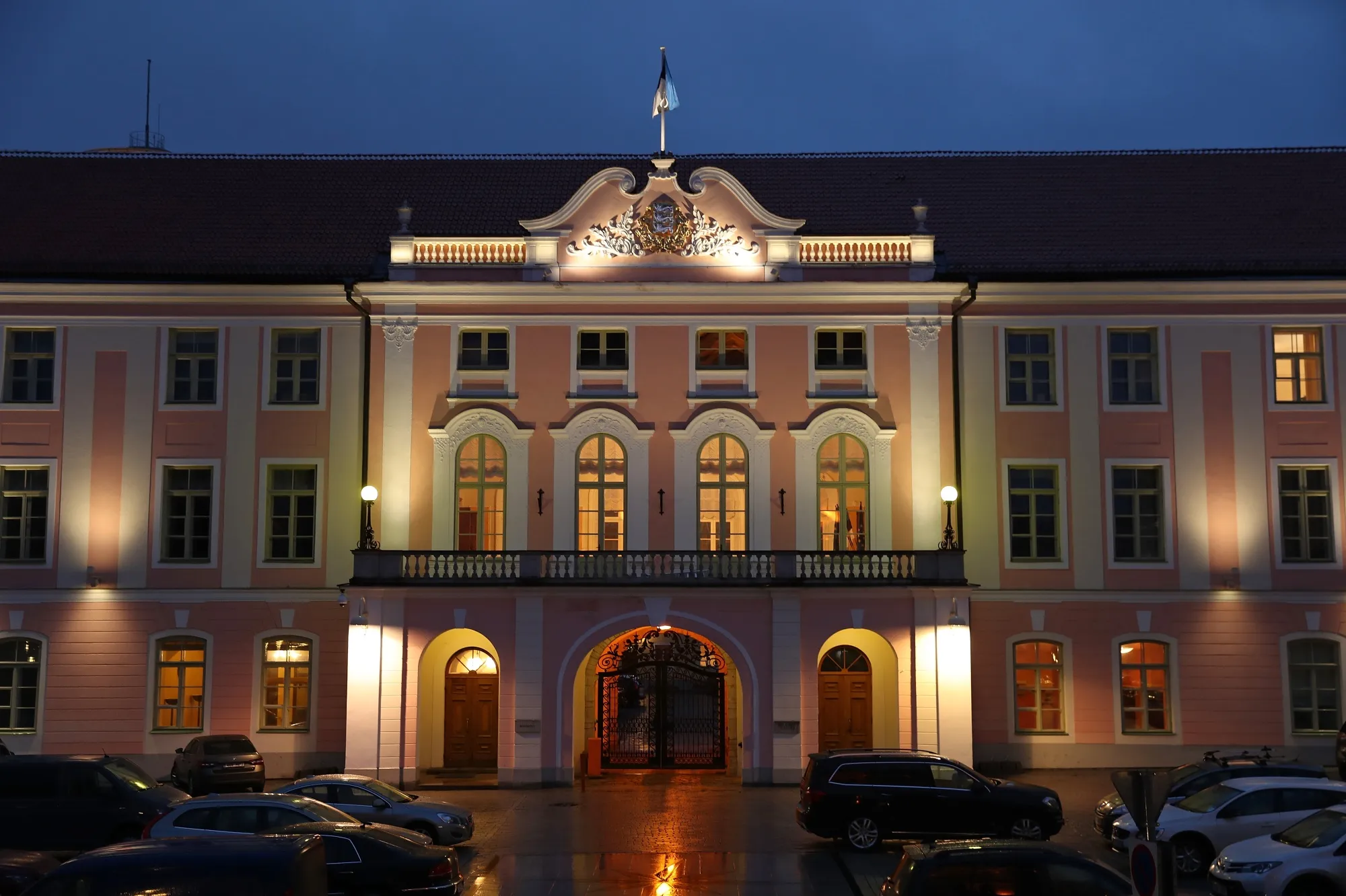
Estonia operates as a parliamentary republic, characterized by a democratic framework that emphasizes transparency and accountability. The President serves as the ceremonial head of state, elected by the Parliament (Riigikogu) or an electoral body for a five-year term.
The President’s role, while largely symbolic, includes representing the country internationally and ensuring that laws passed by the Riigikogu align with the Constitution. The Prime Minister, appointed by the President and confirmed by the Riigikogu, holds the executive power and is responsible for leading the government, forming coalitions, and implementing policies.
Flag Of Estonia
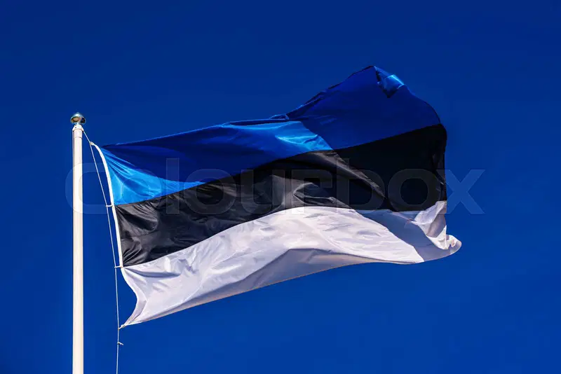
The Estonian flag, known as the "sinimustvalge" (blue-black-white), features three horizontal stripes symbolizing the nation’s identity and aspirations. The bluerepresents the sky, sea, and hope for the future, while blacksignifies the fertile soil and the struggles endured by the Estonian people. Whitereflects purity, peace, and the snowy landscapes of the country, symbolizing a bright future and unity.
First adopted by university students in 1884, the flag became a symbol of Estonia’s nationalist movement and later its independence. Banned during Soviet occupation, it resurfaced as a powerful emblem of resistance. Officially reinstated in 1990, the flag today represents Estonia’s resilience and pride, displayed during national holidays, cultural events, and international gatherings.
Types Of Liechtenstein Maps
- Political Maps: These maps display administrative boundaries, including counties, municipalities, and cities such as Tallinn, Tartu, and Narva. They help users understand the political divisions and governance structure of Estonia, making them valuable for administrative and academic purposes.
- Physical Maps: Physical maps illustrate Estonia’s natural features, such as rivers, forests, lakes, and elevation differences. They highlight prominent landscapes like Lake Peipus, one of Europe’s largest lakes, and the country’s extensive peat bogs, which cover about one-fifth of its area.
- Tourist Maps: Designed for travelers, tourist maps highlight Estonia’s must-see attractions, from medieval castles to pristine beaches. They often include walking trails, cultural landmarks, and national parks, such as Lahemaa and Soomaa, helping visitors plan their itineraries effectively.
- Transportation Maps: These maps focus on road networks, railways, ferry routes, and cycling paths. They include major highways like the Via Baltica and public transport systems in urban areas, ensuring efficient navigation for both locals and visitors.
- Climate Maps: Climate maps provide a visual representation of Estonia’s weather patterns, temperature zones, and precipitation levels. These maps are especially useful for understanding seasonal variations, such as the snowy winters and mild, humid summers.
- Historical Maps: Historical maps showcase Estonia’s territorial changes and historical events. They offer insights into the country’s past, including periods of Swedish, Russian, and German rule, making them invaluable for history enthusiasts.
Liechtenstein’s Borders And Neighboring Countries
Estonia is strategically located in northeastern Europe, sharing borders with:
- Latvia: To the south, with a land border stretching 343 kilometers. Latvia and Estonia share cultural similarities, but each has distinct traditions. The border region is rich in forests and nature reserves.
- Russia: To the east, with a border marked by the Narva River and Lake Peipus. This boundary reflects a mix of historical ties and current geopolitical dynamics.
Estonia is also close to:
- Finland: To the north, across the Gulf of Finland. The two countries are connected by frequent ferry services and have strong cultural and economic ties.
- Sweden: Across the Baltic Sea to the west, historically linked through trade and governance.
These borders define Estonia’s geopolitical position and facilitate cultural and economic exchanges with neighboring countries.
National Parks And Landscapes
1. Lahemaa National Park
Established in 1971, Lahemaa is Estonia’s first and largest national park, spanning over 70,000 hectares along the northern coast. Its name translates to "Land of Bays," reflecting the park's lovely coastline dotted with peninsulas and inlets. The park is a biodiversity hotspot, encompassing dense pine forests, sprawling peat bogs, and rugged rocky beaches.
2. Soomaa National Park
Located in southwestern Estonia, Soomaa National Park is renowned for its extraordinary "fifth season" when spring floods transform the landscape into a vast aquatic expanse. Covering around 39,000 hectares, the park is dominated by wetlands, including extensive bogs, swamp forests, and floodplains.
3. Matsalu National Park
A paradise for birdwatchers, Matsalu National Park lies along the western coast of Estonia, encompassing over 48,000 hectares of wetlands, coastal meadows, and shallow bays. Recognized as a UNESCO wetland of international importance, the park serves as a crucial stopover for migratory birds, hosting up to 2 million birds during spring and autumn migrations.
4. Karula National Park
Located in the rolling hills of southern Estonia, Karula National Park is the smallest of the country’s national parks, covering 12,000 hectares. It is celebrated for its beautiful landscape of gentle hills, scattered lakes, and traditional farmsteads. The park offers a relaxing retreat, with numerous hiking and cycling trails weaving through its diverse areas. The Ähijärve hiking trail is particularly popular, offering stunning views of Lake Ähijärv and its surrounding woodlands.
5. Vilsandi National Park
Located on the western coast of Estonia, Vilsandi National Park encompasses over 23,000 hectares of marine and coastal ecosystems. Established initially as a bird sanctuary in 1910, the park is now a vital area for biodiversity conservation. It includes more than 150 small islands, sandy beaches, and shallow bays, making it a haven for seals and coastal birds.
Liechtenstein’s Natural Wonders On The Map
1. Kaali Meteorite Crater
Located on Saaremaa Island, the Kaali Meteorite Crater is one of Estonia’s most intriguing natural landmarks. Formed around 4,000 years ago by a meteorite that fragmented upon entering the Earth’s atmosphere, the site comprises nine craters, with the largest measuring about 110 meters in diameter and 22 meters deep.
The impact was so powerful that it is believed to have caused widespread fires and had a lasting cultural impact, inspiring myths and legends among ancient communities. For couples looking for best wedding destinations, the Kaali Meteorite Crater offers a unique and historic backdrop, blending natural beauty with an air of mystery.
2. Suur Munamägi
At 318 meters above sea level, Suur Munamägi, sometimes known as "Big Egg Mountain," is the highest point in the Baltic States. Part of the Haanja Nature Park, this natural wonder offers stunning views of the surrounding countryside and is situated in the gently rolling hills of southern Estonia. One of the main attractions at the top is an observation tower that offers visitors sweeping views of farmland, lakes, and forests.
3.. Jägala Waterfall
Located about 30 kilometers east of Tallinn, Jägala Waterfall is Estonia’s largest and widest natural waterfall, with a height of 8 meters and a width of over 50 meters. The Jägala River flows over a limestone escarpment, creating a cascading curtain of water that varies in appearance with the seasons. As a popular tourist attraction, Jägala Waterfall offers a unique winter experience with its frozen cascades and enchanting icy formations. During the summer, the waterfall is surrounded by lush vegetation, creating a picturesque retreat for nature lovers.
Major Roads And Transportation
- Roads: Estonia’s highways, such as the Tallinn-Tartu-Võru-Luhamaa Road, connect major cities and towns. Smaller roads lead to rural areas and nature spots.
- Ferries: The ferry network links the mainland to islands like Saaremaa and Hiiumaa, making them accessible for exploration.
- Railways: Rail services connect cities like Tallinn, Tartu, and Narva, offering a scenic and eco-friendly mode of travel.
- Cycling Paths: Estonia has an extensive network of bike trails, including EuroVelo routes, ideal for cycling enthusiasts.
Climate Map
Estonia experiences a temperate climate influenced by the Baltic Sea:
- Coastal Regions: Milder winters and cooler summers due to maritime influence. Towns like Pärnu and Tallinn experience a more stable climate.
- Inland Areas: Colder winters and warmer summers, with greater temperature fluctuations. Regions like Tartu are ideal for experiencing Estonia’s seasonal changes.
Modern Use Of Estonia’s Map In Technology
Estonia is a pioneer in digital technology, and its mapping tools reflect this innovation. The country offers sophisticated online maps and e-services that provide real-time information about transport, property boundaries, and natural resources.
The integration of technology is also evident in Estonia’s e-Residency program, which allows global citizens to manage businesses in Estonia remotely. Accurate and user-friendly digital maps are integral to these services, making Estonia a leader in geographic information systems (GIS).
15 Interesting Facts About Estonia
1. Digital Society Pioneer
Estonia is one of the most digitally advanced countries in the world. It was the first nation to offer e-Residency, enabling people worldwide to establish businesses digitally. Estonians also vote online and access nearly all government services electronically.
2. Over 50% Of The Country Is Forest
Approximately 51% of Estonia is covered by forests, making it one of Europe’s greenest countries. The diverse woodlands are home to wildlife like lynxes, wolves, and bears.
3. Singing Revolution
In the late 1980s, Estonia achieved independence from the Soviet Union through a peaceful movement called the Singing Revolution. Massive singing demonstrations played a key role in restoring the country's sovereignty.
4. The Most UNESCO Biosphere Reserves In The Baltics
Estonia has several UNESCO-protected areas, including Matsalu National Park and Lahemaa National Park, which are recognized for their biodiversity and cultural importance.
5. Kaali Meteorite Crater
Estonia is home to one of the rare meteorite craters that struck a populated area. The Kaali Crater on Saaremaa Island is an archaeological and geological wonder.
6. Inventor Of Skype
The popular communication platform Skype was developed in Estonia. This innovation underscores the country’s reputation as a tech powerhouse.
7. Small Population, Large Land Area
Estonia has one of the lowest population densities in Europe, with only 1.3 million people living there. Its expansive vistas seem quiet and undisturbed.
8. Over 2,000 Islands
Estonia boasts over 2,000 islands, each with its own charm and history. Saaremaa and Hiiumaa are the largest and most well-known islands.
9. Tallinn’s Medieval Old Town
Tallinn’s Old Town is a UNESCO World Heritage Site and one of the best-preserved medieval cities in Europe. Its cobblestone streets and ancient buildings transport visitors back in time.
10. World-Class Digital Infrastructure
Estonia was the first country to declare internet access as a human right. Free public Wi-Fi is available almost everywhere.
11. Second-Highest Literacy Rate In The World
Estonia boasts an impressive literacy rate of over 99.8%, reflecting its strong emphasis on education and learning.
12. Unique Saunas
Estonians enjoy traditional smoke saunas, a UNESCO-recognized cultural heritage. These saunas are deeply rooted in the country's customs and traditions.
13. White Nights In Summer
During summer, Estonia experiences “White Nights,” when the sun barely sets, creating nearly 24 hours of daylight. This phenomenon is most prominent in northern Estonia.
14. Language With Nordic Influence
Estonian is a Finno-Ugric language, closely related to Finnish. It is known for its unique sounds and 14 grammatical cases.
15. Rich In Lakes And Bogs
Estonia's geography is characterized by a large number of bogs and over 1,400 lakes. Boardwalk routes are available on many bogs allowing tourists to enjoy these peaceful settings.
FAQs
What Are The Main Physical Features On Estonia’s Map?
Estonia’s map is characterized by its Baltic coastline, islands like Saaremaa and Hiiumaa, and freshwater lakes such as Lake Peipus and Lake Võrtsjärv.
Are There Detailed Hiking Maps Available For Estonia?
Yes, detailed hiking maps for national parks like Lahemaa and Soomaa are available online and in print, offering routes and points of interest.
What Is Unique About Estonia’s Digital Maps?
Estonia’s digital maps integrate with e-services, providing real-time information for navigation, land management, and urban planning.
Can I Access Maps Of Estonia In Different Languages?
Yes, maps are available in multiple languages, including Estonian, English, and Russian, catering to locals and international visitors.
What Makes Estonia’s Ice Roads Special?
During winter, some routes across frozen sea areas are opened as ice roads, a unique and thrilling experience.
Conclusion
The Estonian map reflects the history, culture, and inventiveness of the nation and is more than just a geographical tool. Estonia's map depicts a tale of change and resiliency, from ancient cities to contemporary digital services.
Estonia's map provides information on a country that skillfully strikes a balance between tradition and modernity, if you're planning a trip there, researching its geography, or just browsing the globe from your computer.
Jump to
Quick Facts About Estonia
Overview Of Estonia’s Geography
Capital Of Estonia
Map Of Estonia Cities
Estonia’s Administrative Divisions
Population Of Estonia
Currency Of Estonia
Dialing Code Of Estonia
Language Of Estonia
Total Area Of Estonia
Government Of Estonia
Flag Of Estonia
Types Of Liechtenstein Maps
Liechtenstein’s Borders And Neighboring Countries
National Parks And Landscapes
Liechtenstein’s Natural Wonders On The Map
Major Roads And Transportation
Climate Map
Modern Use Of Estonia’s Map In Technology
15 Interesting Facts About Estonia
FAQs
Conclusion

Michael Rachal
Author
Michael Rachal believes that luxury lies in the details. With over 20 years of experience in the luxury travel industry, he has crafted hundreds of bespoke itineraries for clients seeking personalized, unforgettable experiences.
Whether guiding clients through private cultural tours or curating culinary journeys with world-renowned chefs, Michael ensures that each trip is tailored to perfection.
His ability to anticipate needs and exceed expectations has earned him a reputation as a leading expert in luxury travel.

Finn Wilde
Reviewer
For Finn Wilde, the wilderness is more than just a destination - it’s a way of life. Over the past decade, he has led multiple expeditions in some of the world’s most remote regions, from the icy fjords of Greenland to the rugged trails of Patagonia.
Finn emphasizes sustainability in all of his adventures, helping participants connect with nature while promoting responsible exploration. His expeditions inspire individuals to explore the great outdoors while fostering a deep respect for the environment.
Latest Articles
Popular Articles