Map Of Scotland | Key Regions, Cities, And Landmarks
Understanding the map of Scotland is crucial for any traveler. This guide will help you navigate this beautiful country with ease.
Author:Finn WildeReviewer:Michael RachalJul 28, 202566.1K Shares1.5M Views
Imagine yourself standing on a windswept cliff overlooking the dramatic coastline of Scotland. The air is crisp, the sea roars in the distance, and the only sound is the cry of a distant seabird. This is the magic of Scotland, a land of rugged beauty and ancient legends, waiting to be revealed.
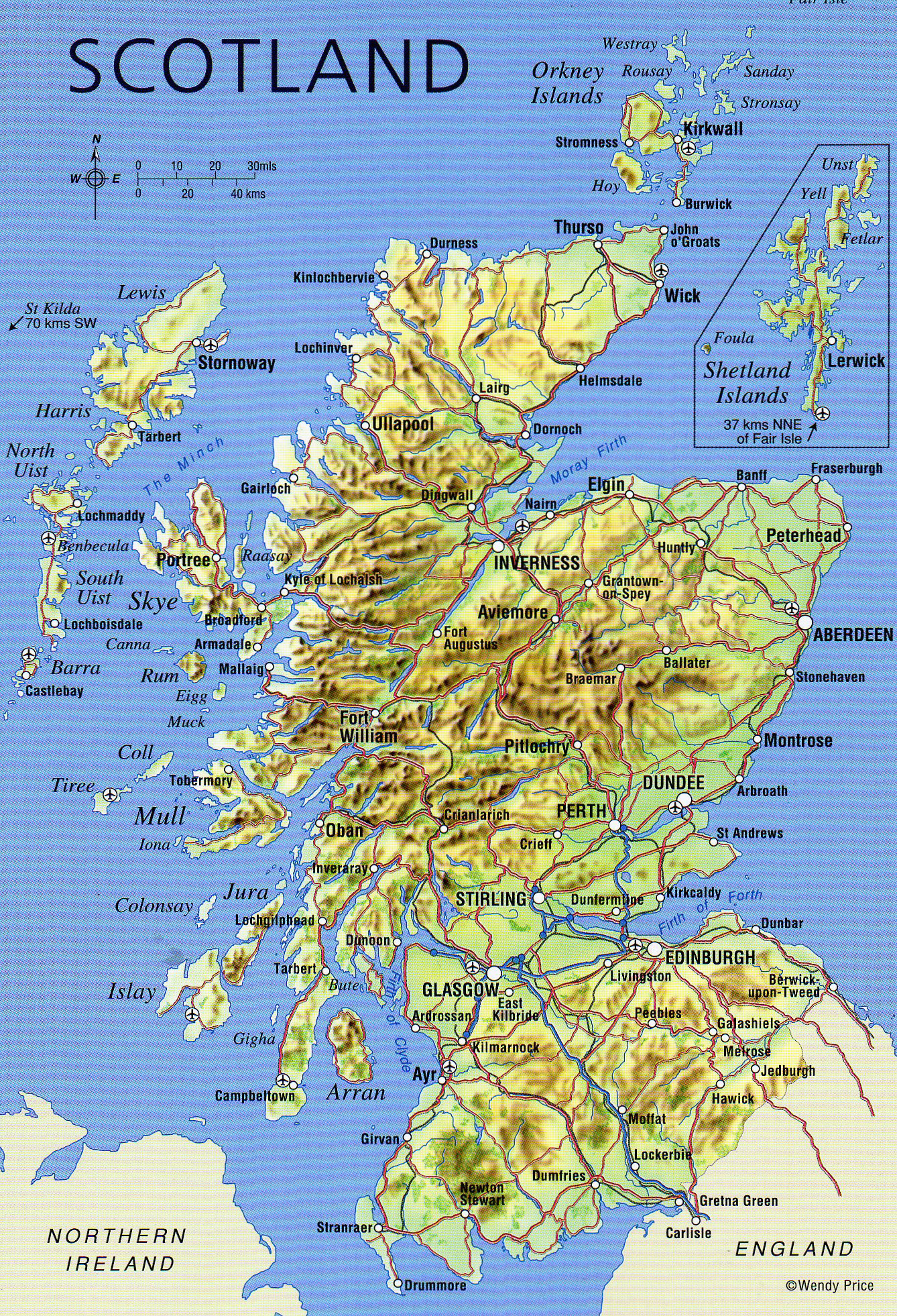
Scotland, which makes up the northern third of the island of Great Britain, is a fascinating combination of history, culture, and stunning natural beauty. A simple map of Scotlandcan help you visualize this country's vast landscapes, from its towering mountains to its sweeping shorelines.
This essay will examine the intricate details of the Scottish map, including its historical significance, geographical aspects, and how a deeper grasp of the map can lead to a greater appreciation of this wonderful country.
Geographical Overview Of Scotland
Scotland is geographically diverse, boasting a landscape that ranges from wild mountains to fertile plains. It shares a land border with England to the south and is surrounded by the Atlantic Ocean to the west and north, and the North Sea to the east. For those planning to visit the beauty of the eastern parts, using google maps scotland east coastcan provide detailed insights into the best routes, coastal towns, and hidden gems along the way.
- Highlands:The Highlands dominate much of northern and western Scotland, characterized by towering mountains, deep glens, and numerous lochs (lakes). Ben Nevis, the highest peak in the British Isles, resides here.
- Lowlands:The Lowlands occupy the southern and eastern parts of Scotland, featuring rolling hills, fertile farmlands, and major cities like Edinburghand Glasgow.
- Islands:Scotland boasts a vast archipelago, including the Inner Hebrides (such as the Isle of Skye and Islay) and the Outer Hebrides (such as Lewis and Harris). These islands offer a unique blend of rugged beauty and tranquility.
- Coastline:The Scottish coastline is renowned for its dramatic beauty, featuring towering cliffs, hidden coves, and numerous bays and inlets.
Historical Significance Of Scotland's Geography
- Viking Invasions:The wild coastline and numerous islands made Scotland vulnerable to Viking invasions during the 8th and 9th centuries. These invasions left a lasting impact on Scottish culture and language.
- Highland Clearances:In the 18th and 19th centuries, the Highland Clearances, a series of forced evictions of Highland communities, were significantly influenced by the geography of the region. The mountainous terrain and limited arable land made it difficult for traditional Highland agriculture to survive.
- Trade and Commerce:Scotland's strategic location on the North Atlantic played a crucial role in its development as a center of trade and commerce. Its numerous ports facilitated maritime trade with other European countries and beyond.
Map Of Scotland Cities
Northern Scotland Cities
1. Inverness
Known as the "Capital of the Highlands," Inverness is a picturesque city located where the River Ness meets the Moray Firth. It serves as a cultural and commercial hub for the Highland region. Inverness is famous for its proximity to Loch Ness, home to the legendary Loch Ness Monster. The city boasts landmarks such as Inverness Castle, which overlooks the city, and the Victorian Market, a lively shopping destination.
2. Aberdeen
Aberdeen, also known as the "Granite City," is renowned for its striking grey-stone buildings made from local granite that sparkles in sunlight. As one of Scotland's largest cities, it is a key center for the oil and gas industry. Its bustling Aberdeen Harbour connects it to the North Sea, making it a vital port. The city offers attractions such as St. Machar's Cathedral, which dates back to the 12th century, and Duthie Park Winter Gardens, one of Europe’s largest indoor gardens.
4. Elgin
Elgin, a charming town in the heart of Moray, is a treasure trove of history, culture, and natural beauty. Known for its rich heritage, it is often celebrated as one of Scotland's most wonderful and historically significant towns. At the heart of Elgin lies the majestic Elgin Cathedral, often referred to as the "Lantern of the North." Built in the 13th century, the cathedral was once one of Scotland's most impressive religious structures. Despite falling into ruin after the Reformation, its intricate stonework, lofty towers, and serene grounds continue to captivate visitors. The cathedral is surrounded by lush gardens, making it a peaceful spot to reflect and soak in the town's history.
Central Scotland Cities
5. Perth
Located along the banks of the River Tay, Perth is often called the "Gateway to the Highlands." This historic city played a crucial role in Scotland's medieval history, with kings being crowned at Scone Palace, located nearby. Perth is also a hub for arts and culture, with attractions such as the Perth Museum and Art Gallery. Its well-maintained parks, like the North Inch, provide relaxing spots for locals and visitors. The city is surrounded by picturesque countryside, offering opportunities for outdoor activities.
6. Stirling
Stirling is rich in history and is often referred to as the "Key to Scotland" due to its strategic location. The city is dominated by the impressive Stirling Castle, a former royal residence with breathtaking views of the surrounding area. Stirling is also home to the Wallace Monument, a towering tribute to William Wallace, the Scottish hero depicted in the film Braveheart. The nearby Bannockburn Battlefield commemorates Robert the Bruce's victory over the English in 1314. Stirling's old town features cobbled streets and centuries-old architecture, transporting visitors back in time.
7. Dundee
Dundee, Scotland’s fourth-largest city, is a dynamic destination that blends history, innovation, and culture. Known as the "City of Discovery," it is home to the V&A Dundee, a stunning design museum on the waterfront. The city played a major role in shipbuilding and journalism, celebrated at attractions like the RRS Discovery, the ship that carried Captain Scott to Antarctica. Dundee also boasts a vibrant food scene and panoramic views from the Law Hill, an extinct volcanic plug overlooking the city.
Southern Scotland Cities
8. Edinburgh
Edinburgh, Scotland's capital city, is famed for its blend of historic and modern charm. Its iconic skyline is dominated by Edinburgh Castle, perched atop an ancient volcanic rock. The city is rich in cultural experiences, with landmarks such as the Royal Mile, Holyrood Palace, and Arthur's Seat, an extinct volcano offering panoramic views.
Edinburgh is also known for its festivals, particularly the Edinburgh Festival Fringe, the world’s largest arts festival. The city’s medieval Old Town and Georgian New Town are UNESCO World Heritage Sites. After a day of sightseeing, a visit to an edinburgh dineroffers the perfect opportunity to enjoy traditional Scottish dishes and contemporary cuisine in a cozy, welcoming atmosphere.
9. Glasgow
Glasgow, Scotland's largest city, is a cultural powerhouse known for its vibrant arts scene and warm hospitality. Once an industrial hub, it has transformed into a modern metropolis filled with museums, galleries, and music venues. Highlights include the Kelvingrove Art Gallery and Museum, the Glasgow Science Centre, and the Riverside Museum, which celebrates the city’s maritime heritage. Glasgow is also a shopping mecca, with Buchanan Street offering high-end stores and local boutiques. The city’s thriving music scene has earned it recognition as a UNESCO City of Music.
10. Paisley
Located just outside Glasgow, Paisley is celebrated for its rich textile heritage, particularly the iconic Paisley Pattern. The town’s historic Paisley Abbey, founded in the 12th century, is a stunning architectural landmark. Paisley is undergoing a cultural revival, with new arts events and creative spaces transforming it into a vibrant cultural hub.
Western Scotland Cities
11. Fort William
Fort William, often called the "Outdoor Capital of the UK," is a haven for adventure enthusiasts. Situated at the foot of Ben Nevis, the UK’s tallest mountain, it offers activities such as hiking, skiing, and mountain biking. The town is also the starting point for the West Highland Way, a long-distance walking route. Fort William's scenic location on the shores of Loch Linnhe makes it a perfect base for exploring the rugged landscapes of the west coast.
12. Oban
Oban, a charming seaside town known as the "Gateway to the Isles," is well-known for its fresh seafood and whisky distilleries. McCaig's Tower, a coliseum-like building that overlooks the town, offers visitors stunning views of the bay. Additionally, Oban is a significant ferry terminal that links passengers to Mull and Iona as well as other Hebridean islands. Both residents and visitors love it for its vibrant harbor and extensive maritime heritage. If you're looking to combine your travels with culinary experiences, traveland taste in Oban, where the fresh seafood and local delicacies are sure to delight your palate.
Regions Of Scotland Highlighted On Maps
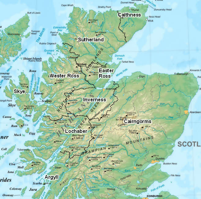
The Highlands
The Highlands are one of the most iconic parts of Scotland, known for their wild beauty and towering mountains. This region is home to famous mountain ranges like the Cairngorms and stunning valleys such as Glen Coe. Maps of the Highlands often focus on the natural beauty of the area, showing hiking trails, scenic viewpoints, and remote locations perfect for outdoor adventures. With vast stretches of untouched wilderness, the Highlands are ideal for those seeking peace, solitude, and a deep connection with nature.
The Lowlands
The Lowlands offer a striking contrast to the Highlands, blending modern city life with lush countryside. This region includes Scotland's two largest cities, Edinburgh and Glasgow, known for their history, culture, and vibrant urban life. Maps of the Lowlands also highlight rolling farmlands, charming villages, and historical landmarks such as castles and battlefields. The Lowlands are a perfect mix of Scotland’s past and present, providing something for every kind of traveler.
The Islands
Scotland’s islands are a world of their own, each with unique character and charm. The Hebrides, Shetland, and Orkney are among the most well-known groups of islands. Maps of these areas show ferry routes, secluded beaches, and ancient ruins like the Neolithic settlement of Skara Brae in Orkney. The islands are famous for their rich wildlife, including puffins and seals, and their strong cultural traditions, such as Gaelic language and music.
National Parks And Protected Areas
Scotland has two main national parks: Cairngorms and Loch Lomond & The Trossachs. These parks are showcased on maps that highlight their beautiful landscapes, walking paths, and opportunities to see wildlife. The Cairngorms is known for its mountain ranges and ski resorts, while Loch Lomond & The Trossachs features sparkling lochs, forested hills, and peaceful villages. Maps of these parks are invaluable for anyone looking to enjoy Scotland’s great outdoors, from hiking and cycling to fishing and birdwatching.
Total Area Of Scotland
Scotland covers an area of approximately 77,933 square kilometers (30,090 square miles), making it the second-largest country in the United Kingdom after England. Its geography is defined by a striking variety of landscapes:
- The Highlands and Islands feature towering mountains, glacial valleys, and rugged coastlines.
- The Lowlands offer fertile plains and rolling hills, where most of the population resides.
- Scotland also boasts 790 islands, of which around 130 are inhabited, including the Orkney, Shetland, and Hebrides archipelagos.
Population Of Scotland
Scotland has a population of approximately 5.5 million peopleas of recent estimates. The population is concentrated in the Central Belt, which includes major cities like Glasgow, Edinburgh, and Dundee. Rural areas, such as the Highlands and Islands, are more sparsely populated, reflecting Scotland's rugged geography and expansive wilderness. Over recent decades, urban centers have experienced growth due to economic development, while some remote areas have seen population declines.
Currency Of Scotland
The official currency of Scotlandis the Pound Sterling (£), which is also used across the United Kingdom. However, Scotland has its unique banknotes issued by three major Scottish banks: The Royal Bank of Scotland, Bank of Scotland, and Clydesdale Bank.
Dialing Code Of Scotland
The international dialing code for Scotland is +44, which is shared with the rest of the United Kingdom. When calling a Scottish phone number from abroad, you would typically dial the country code +44, followed by the local area code (without the initial '0') and the phone number. For example, to reach a number in Edinburgh (area code 0131), you would dial +44 131 [number]. Scotland’s well-established telecommunications infrastructure ensures seamless connectivity across its cities and rural areas.
Language Of Scotland
Scotland has three main languages:
- English:The predominant language spoken by the majority of Scots in daily life.
- Scottish Gaelic:A Celtic language with ancient roots, spoken primarily in the Highlands and Islands. Efforts to preserve and promote Gaelic include bilingual signage and Gaelic-medium schools.
- Scots:A language variety distinct from standard English, with regional dialects like Doric in the northeast and Borders Scots in the south. Scots is widely spoken and features prominently in Scottish literature and poetry.
Multilingualism reflects Scotland's rich cultural heritage and ongoing efforts to preserve its linguistic diversity.
Flag Of Scotland
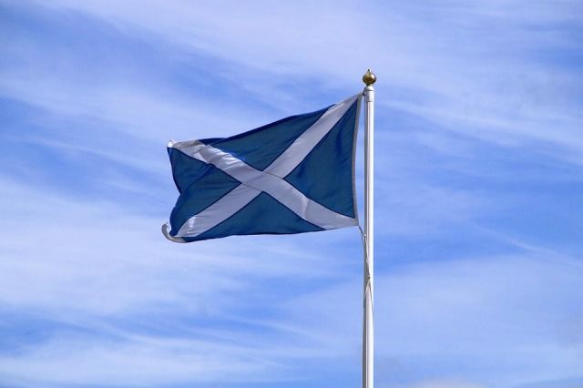
The flag of Scotland, known as the Saltireor the Saint Andrew’s Cross, is one of the oldest flags in the world. It consists of a white diagonal cross on a blue background, symbolizing Saint Andrew, Scotland's patron saint. According to legend, the design was inspired by a 9th-century battle where a white cross appeared against a blue sky, leading to victory. Today, the Saltire represents Scotland’s national identity and is flown proudly across the country, especially on St. Andrew’s Day(November 30) and during major sporting events.
Government Of Scotland
Scotland operates under a devolved government as part of the United Kingdom. The Scottish Government has powers over areas such as health, education, and justice, while issues like defense and foreign affairs remain under the UK Government.
- The Scottish Parliament, based in Edinburgh, consists of 129 Members of the Scottish Parliament (MSPs) and is responsible for passing laws and scrutinizing the government.
- The First Minister of Scotland leads the government and represents Scotland on a national and international level.
Types Of Maps Of Scotland
1. Physical Maps
Physical maps showcase Scotland’s dramatic topography, from the Highlands' rugged terrain to the soft rolling hills of the Lowlands. Rivers like the Clyde and Tay and lochs like Ness and Katrine are also prominent features.
2. Political Maps
Political maps detail Scotland's regions, including major cities like Edinburgh and Glasgow, and the smaller administrative divisions that define local governance.
3. Historical Maps
Scotland’s historical maps capture its evolution, showcasing ancient clan territories, old trade routes, and significant historical sites. They’re essential for understanding Scotland’s role in European history.
4. Tourist Maps
Tourist maps focus on Scotland’s attractions, such as Edinburgh Castle, the Isle of Skye, and the North Coast 500 driving route. These maps help visitors plan their journeys efficiently.
5. Custom Maps
Unique maps, such as whisky trails or Scotland’s literary landmarks, cater to niche interests, providing specialized insights into Scotland’s cultural and artisanal richness.
Scottish Coastline Map
1. Major Coastal Regions
A coastline map divides Scotland into distinct coastal regions, each with its unique charm:
- North Coast:Famous for the NC500 route, it features remote beaches, sea stacks like the Old Man of Stoer, and cliffs teeming with seabirds.
- East Coast:Known for lovely fishing villages, historic harbors, and sandy beaches like St. Andrews and Aberdeen.
- West Coast:A haven of fjord-like lochs, islands, and rugged beauty, including the Isle of Skye and Torridon.
- South Coast:Highlights the Solway Firth and Dumfries & Galloway, known for their tranquil beaches and wildlife-rich areas.
2. Coastal Highlights
- Seaside Towns:Such as Oban, St. Andrews, and Wick, known for their history, seafood, and charm.
- Islands:The map outlines ferry routes to the Hebrides, Orkney, and Shetland, along with their coastal attractions.
- Lighthouses:Locations of famous lighthouses, such as Kinnaird Head and Eilean Glas, are often noted for their scenic and historic value.
3. Activities And Routes
- Walking Trails:Scotland’s Great Coastal Walks like the Fife Coastal Path and Moray Coast Trail are typically highlighted for hikers.
- Wildlife Hotspots:Maps often indicate areas for dolphin spotting (Moray Firth), puffin colonies (Isle of May), and seal watching.
- Adventure Spots:From surfing beaches like Thurso to kayaking routes in the sea lochs, the map guides adventurers.
4. Geographical Features
Scottish coastline maps emphasize the region's natural diversity, including:
- Cliffs and Stacks:Locations such as Duncansby Stacks and the Kilt Rock on the Isle of Skye.
- Sandy Beaches:Like Balnakeil, Luskentyre, and Seacliff, famous for their pristine beauty.
- Sea Lochs and Fjords:Loch Torridon and Loch Eriboll showcase Scotland’s fjord-like geography.
5. Historical Sites
The map includes markers for historical sites along the coast:
- Castles:Such as Dunnottar Castle perched on cliffs and Castle Stalker surrounded by water.
- Ancient Ruins:Sites like Jarlshof in Shetland and the Broch of Gurness in Orkney are notable.
- Shipwreck Sites:Particularly along the Orkney coastline, where World War relics are of interest.
Neighboring Countries Highlighted On A Scotland Map
Scotland, located in the northern part of the United Kingdom, shares its borders with a single neighboring country:
England
- Scotland shares its only land border with Englandto the south.
- The border stretches for approximately 96 miles (154 km)from the Solway Firthin the west to the River Tweedin the east.
- Key landmarks along the border include Hadrian’s Wall, an ancient Roman fortification, and Berwick-upon-Tweed, a historically significant town.
- The border region features a blend of rolling hills, picturesque villages, and historic sites, reflecting centuries of shared and contested history.
Proximity To Other Countries
Although Scotland does not share land borders with other nations, its geographical location provides close proximity to other countries:
Ireland
- To the southwest across the Irish Sea, Scotland is closest to Northern Ireland. The shortest distance between the two is about 12 miles (19 km)across the North Channel.
- The connection fosters cultural and historical ties between Scotland and Ireland.
Norway
Across the North Sea to the northeast, Scotland is close to Norway. This proximity highlights historical links between the Vikings and Scottish coastal communities, particularly in the Shetland and Orkney Islands.
Iceland And Denmark (via Faroe Islands)
Iceland and Denmark’s Faroe Islands lie further afield in the Atlantic Ocean but have historical and cultural associations with Scotland’s northern islands.
Scotland’s Maritime Borders
Scotland’s extensive coastline interacts with several seas that act as maritime borders:
- The North Seato the east connects Scotland with mainland Europe.
- The Atlantic Oceanto the west opens up routes to the Americas.
- The Irish Seaand North Channelform the maritime link to Ireland.
Scotland's Bordering Regions And International Relations
Scotland’s position, sandwiched between the North Sea and the Atlantic Ocean, has made it a cultural crossroads for centuries.
- The Anglo-Scottish borderhas been a site of historic conflict and cooperation, but today, it is a peaceful line of demarcation.
- The maritime borders with Norway, Ireland, and the Faroe Islandsunderscore Scotland’s role as a vital point of connection within Europe and the Atlantic.
- Trade, Tourism, and Cultural Exchange:Modern Scotland continues to maintain strong relations with its neighbors through tourism, economic ties, and cultural exchanges. The proximity to countries like Ireland and Norway enables a flow of ideas, people, and goods, fostering a sense of unity in the region.
Scotland's Natural Wonders On The Map
1. Loch Ness - The Famous Loch
Located in the Scottish Highlands, Loch Ness is one of the most famous lakes in the world, not just for its natural beauty but also for its legendary resident, Nessie, the Loch Ness Monster.
- Location:Situated near the town of Inverness, Loch Ness stretches approximately 23 miles (37 km)in length and is the second-largest loch in Scotland by surface area.
- Why It’s Special:The loch is surrounded by steep hills and forests, making it a stunning spot for photography, hiking, and boat tours. The Urquhart Castle on its shores adds to the allure, offering dramatic views of the loch.
2. The Isle Of Skye - A Wild And Beautiful Island
The Isle of Skye, located off the west coast of Scotland, is famous for its dramatic landscapes, including jagged mountains, deep lochs, and coastal cliffs.
- Location:It is part of the Inner Hebrides and can be accessed from the mainland via the Skye Bridgeor ferries from Mallaig and Armadale.
- Why It’s Special:Skye is renowned for its rugged beauty, particularly the Old Man of Storr, Fairy Pools, and The Quiraing; a landscape of dramatic cliffs and rock formations. It is also known for its diverse wildlife and historical sites, including the Dunvegan Castle.
3. Cairngorms National Park - Scotland’s Majestic Mountain Range
The Cairngorms National Parkis Scotland’s largest national park, located in the heart of the Highlands. This vast area is known for its ancient woodlands, clear lochs, and towering mountains.
- Location:Situated roughly between the cities of Inverness and Aberdeen, the park spans over 1,700 square miles.
- Why It’s Special:The Cairngorms are home to the Cairngorm Mountain, one of the highest peaks in the UK. The park is also a haven for wildlife, with animals like red deer, golden eagles, and wildcats inhabiting the area. Popular activities include hiking, skiing, and wildlife spotting.
4. The Northern Highlands - A Wilderness Of Beauty
The Northern Highlandsare one of Scotland’s most remote and beautiful regions, featuring vast stretches of wilderness with few settlements and an abundance of natural beauty.
- Location:Covering the northernmost part of the country, the Northern Highlands include areas like Caithness, Sutherland, and Ross and Cromarty.
- Why It’s Special:This region is home to some of Scotland's most impressive landscapes, including the North Coast 500 route, which offers spectacular views of cliffs, beaches, and lochs. Notable spots include Smoo Cave (a sea cave), Loch Eriboll, and Ben Hope, the northernmost munro in Scotland.
5. Ben Nevis - Scotland’s Highest Peak
Ben Nevis, located near the town of Fort William in the Scottish Highlands, is the tallest mountain in the United Kingdom, standing at 4,413 feet (1,345 meters).
- Location:Ben Nevis is part of the Grampian Mountain Range and is easily accessible from Fort William.
- Why It’s Special:As the highest mountain in the UK, Ben Nevis attracts hikers and climbers from around the world. The summit offers stunning panoramic views of the surrounding area, including Loch Linnhe and the Glen Nevis valley. The mountain is also home to a variety of wildlife and unique alpine plants.
6. The Trossachs - Scotland’s Lake District
The Trossachs, located in central Scotland, is often referred to as the Gateway to the Highlands. This area is known for its scenic lochs, forests, and rolling hills.
- Location:Nestled between Loch Lomond and Callander, the Trossachs are easily accessible from Glasgow and Stirling.
- Why It’s Special:The Trossachs is famous for its picturesque lochs, particularly Loch Katrine and Loch Achray, surrounded by forests and mountains. The area is perfect for walking, cycling, and boating, and is deeply connected to Scottish culture, as it inspired works by Sir Walter Scott.
7. The Orkney Islands - Ancient Landscapes And Seabirds
The Orkney Islands, an archipelago located to the north of mainland Scotland, are known for their dramatic cliffs, prehistoric sites, and rich birdlife.
- Location:Situated off the northeast coast of Scotland, the Orkney Islands are easily reached by ferry or plane from the mainland.
- Why It’s Special:Wildlife, especially seabirds, thrive in Orkney, which is also home to significant archeological sites like the Ring of Brodgar, a prehistoric stone circle, and Skara Brae, a Neolithic town. The islands' natural coastline provides chances for adventure outside as well as stunning views.
8. The Shetland Islands - Scotland’s Northernmost Isles
The Shetland Islands, located to the far north of Scotland, offer some of the most remote and rugged landscapes in the country.
- Location:Situated approximately 200 miles north of the Scottish mainland, the Shetland Islands can be accessed by ferry or flight from mainland Scotland.
- Why It’s Special:Known for their stunning coastal scenery, the Shetlands are home to steep cliffs, deep fjords, and white-sand beaches. The islands also boast a rich Viking heritage, which can be enjoyed at various archaeological sites and festivals. The Shetland Islands are a prime destination for birdwatching, particularly for puffins, and are famous for their wildlife, including seals and otters.
9. The Isle Of Harris - Dramatic Beaches And Mountains
Located in the Outer Hebrides, the Isle of Harris is a place of unspoiled beauty, with a coastline dotted with some of the most beautiful beaches in the world.
- Location:The Isle of Harris is connected to the Isle of Lewis in the Outer Hebrides and can be accessed by ferry from Uigon the Isle of Skye.
- Why It’s Special:Harris is home to stunning beaches like Luskentyre and Seilebost, as well as towering mountain peaks such as Hecla. The island’s dramatic landscape, coupled with its natural coastline, makes it a paradise for outdoor enthusiasts, particularly those interested in hiking, kayaking, and wildlife spotting.
10. Stirling - Scotland’s Historic Gateway
Steeped in history, Stirling is a small city in central Scotland that has played a pivotal role in the country’s past, especially during the Wars of Scottish Independence.
- Location:Central Scotland, between Edinburgh and the Highlands.
- Why It’s Special:Stirling is home to the historic Stirling Castle, the site of the Battle of Stirling Bridge, and the Wallace Monument, a tribute to William Wallace, Scotland’s national hero. Stirling provides a blend of history and natural beauty, set against a backdrop of scenic hills and rivers.
How To Use A Map Of Scotland For Travel
1. Identify Key Regions
Scotland is divided into several distinct regions, each with its own unique attractions and landscapes. Familiarizing yourself with these regions will help you decide where to go. Here’s a quick overview of key areas:
- The Highlands: Known for its rugged mountains, picturesque lochs, and outdoor activities like hiking and wildlife spotting.
- The Lowlands: More urbanized, home to cities like Edinburghand Glasgow, known for culture, history, and festivals.
- The Islands: Comprising famous islands like the Hebrides, Orkney, and Shetland, offering isolated beauty, ancient history, and diverse wildlife.
- National Parks: Cairngorms National Parkand Loch Lomond & The Trossachsare ideal for hiking, cycling, and nature experiences.
2. Understand The Scale And Distance
Maps come in different scales, so it’s important to understand the distances between locations in Scotland, especially since travel times can be longer than expected due to winding roads and mountainous terrain.
- Use the scaleto calculate the distance between cities, towns, and landmarks.
- Estimate travel timesby considering the map’s scale and taking into account road conditions (single-track roads in rural areas can slow down travel).
3. Mark Must-See Tourist Spots
Highlight important tourist spots you want to visit. Scotland is rich in natural and cultural landmarks.
- Edinburgh Castlein the capital.
- Loch Nessin the Highlands.
- Isle of Skyefor breathtaking landscapes.
- Ben Nevisfor hiking.
- Use a highlighter or pinson a physical map or digital markersif you’re using an online map.
- Look for iconic landmarks such as:
4. Plan Your Route
Scotland offers a variety of landscapes and terrain, so planning your route is crucial for making the most of your trip.
- Stick to major roadsfor ease of travel, especially if you’re driving through more rural or remote areas.
- If you’re planning to see the national parks or islands, be aware that some areas might require ferries or special transport, which can be marked on your map.
- Consider a scenic route like the North Coast 500 road trip in the Highlands, which is marked on maps as a circular route for stunning views and attractions.
5. Utilize Map Legends For Features
- Hiking trails (marked with different colors for difficulty)
- Accommodation (hotels, hostels, guesthouses)
- Transport (train stations, airports, bus stops)
- Natural features (lakes, mountains, parks)
- Legend/Key: Maps often include a legend explaining symbols for things like:
This will help you quickly identify relevant sites while traveling and find necessary amenities along the way.
6. Consider Topographic Maps For Hiking
If you’re interested in hiking or seeing Scotland’s natural beauty, a topographic map is a great tool. These maps highlight changes in elevation, mountains, valleys, and terrain features, providing a better understanding of hiking routes.
- Look for detailed maps for areas like Cairngorms National Park or Ben Nevis to find the best trails.
- Use symbols for mountain ranges, lakes, and wildlife viewing areas to enhance your outdoor experience.
7. Use A Digital Map For On-the-Go Navigation
Many travelers prefer digital maps on smartphones or GPS devices for real-time navigation. You can use platforms like Google Maps or specific travel apps like Komoot or ViewRanger for hiking.
- Real-time updates and route recalculations.
- Offline functionality for areas with limited mobile signal.
- Access to user reviews, photo updates, and suggested itineraries.
8. Be Aware Of Hidden Gems
Scotland is full of hidden gems that aren’t always marked on a tourist brochure. Using detailed maps or travel blogscan help you locate some lesser-known spots:
- Hidden beaches along the West Coast.
- Small villages tucked into the hills, like Plockton in the Highlands.
- Ancient ruins or standing stones in more remote areas.
9. Plan Your Stay In Different Regions
When using a map of Scotland, it’s important to group nearby destinations to maximize your time. For example:
- If you’re visiting the Isle of Skye, plan for a stay near Portree, the main town, and make day trips to attractions like the Fairy Pools or Old Man of Storr.
- If heading to Edinburgh, you can check out surrounding areas like Stirling or the Firth of Forth.
10. Map Out Emergency Services And Amenities
Maps often include key emergency services, hospitals, and tourist information centers. Make sure you know where these are, especially if you’re venturing into remote areas like the Cairngorms or Shetland Islands.
- Plan for fuel stops in rural areas, as stations can be sparse in certain regions.
- Keep an eye out for public transport routes in major cities and towns.
11. Check For Seasonal Conditions
Weather plays a huge role in Scotland, particularly in winter when mountain roads or coastal routes may become impassable. Always check weather forecasts and adapt your route accordingly.
Use weather icons or seasonal warnings on the map to assess areas that may be impacted by snow, rain, or floods.
12. Ask Locals For Advice
When traveling, don’t hesitate to ask locals for recommendations on places to visit or the best routes to take. Maps can guide you to a destination, but local insights can offer hidden gems and alternatives.
Interesting Facts About Scotland
- The tallest waterfall in Britain, Eas a' Chual Aluinn, is located in Scotland. It stands 658 feet tall, which is three times the height of Niagara Falls.
- The Unicorn is Scotland's official animal.
- There are approximately 790 islands in Scotland.
- The oldest tree in Europe can be found in Scotland.
- It's a twisted yew that's been around for over 3,000 years.
- Edinburgh was the world's first city to have its own fire department.
- Freshwater lakes cover an area of over 600 square miles.
- Scotland has the highest proportion of redheads.
- The "home of golf" is St. Andrew's Links.
- Despite being the capital, Edinburgh is not the largest city; Glasgow is.
- The raincoat was invented in Scotland by Charles Macintosh, a Glasgow native.
FAQs
Where Is Scotland On The Map?
Scotland is located in the northern part of the United Kingdom, to the north of England. It is bordered by the Atlantic Ocean, with the North Sea to the east and the Irish Sea to the south.
How Accurate Are Historical Maps Of Scotland?
While historical maps provide valuable insights, their accuracy may vary depending on the time period and the cartographer’s resources.
Can I Find Maps Specific To Whisky Trails In Scotland?
Yes, there are custom maps highlighting Scotland’s whisky distilleries and trails, popular among whisky enthusiasts.
How Do I Mark Destinations On A Map?
Use a highlighter on physical maps or pin locations using digital maps like Google Maps.
Where Can I Buy Detailed Physical Maps Of Scotland?
Tourist information centers, bookstores, and online retailers often stock a variety of detailed maps for different purposes.
Conclusion
A map of Scotland is a must-have tool for seeing all that this amazing nation has to offer. With the correct map, you can easily plan your trip, find hidden treasures, and navigate through Scotland's many regions.
If you’re hiking through the Highlands, visiting historic cities, or relaxing on an island, the map will help you make the most of every moment. Take the time to learn how to read it well, and you’ll find that Scotland is an adventure waiting to be mapped out.
Jump to
Geographical Overview Of Scotland
Map Of Scotland Cities
Regions Of Scotland Highlighted On Maps
Total Area Of Scotland
Population Of Scotland
Currency Of Scotland
Dialing Code Of Scotland
Language Of Scotland
Flag Of Scotland
Government Of Scotland
Types Of Maps Of Scotland
Scottish Coastline Map
Neighboring Countries Highlighted On A Scotland Map
Scotland's Natural Wonders On The Map
How To Use A Map Of Scotland For Travel
Interesting Facts About Scotland
FAQs
Conclusion

Finn Wilde
Author
For Finn Wilde, the wilderness is more than just a destination - it’s a way of life. Over the past decade, he has led multiple expeditions in some of the world’s most remote regions, from the icy fjords of Greenland to the rugged trails of Patagonia.
Finn emphasizes sustainability in all of his adventures, helping participants connect with nature while promoting responsible exploration. His expeditions inspire individuals to explore the great outdoors while fostering a deep respect for the environment.

Michael Rachal
Reviewer
Michael Rachal believes that luxury lies in the details. With over 20 years of experience in the luxury travel industry, he has crafted hundreds of bespoke itineraries for clients seeking personalized, unforgettable experiences.
Whether guiding clients through private cultural tours or curating culinary journeys with world-renowned chefs, Michael ensures that each trip is tailored to perfection.
His ability to anticipate needs and exceed expectations has earned him a reputation as a leading expert in luxury travel.
Latest Articles
Popular Articles