Map Of Serbia: Your Ultimate Guide To Regions, History & Key Facts
Comprehensive Serbia map guide: Explore its regions, historical border shifts, and key geographical features. Expert analysis for a complete understanding of the Balkans' heartland.
Author:Michael RachalReviewer:Finn WildeApr 17, 20254.2K Shares132.8K Views
Serbia, located at the heart of the Balkans, is a country known for its rich history, stunning landscapes, and cultural heritage.
Understanding this fascinating country begins with its geography, and a detailed map of Serbiareveals not just its borders and cities, but also the intricate tapestry of its regions, its connection to neighboring nations, and its strategic importance in the Balkan Peninsula. More than just lines on paper, a map of Serbia is a key to unlocking its past, present, and future.
Quick Facts About Serbia
| Fact | Details |
| Official Name | Republic of Serbia |
| Capital | Belgrade |
| Population | ~6.7 million (est.) |
| Area | 77,474 sq km (29,913 sq mi) |
| Official Language | Serbian |
| Currency | Serbian Dinar (RSD) |
| Dialing Code | +381 |
| Government | Parliamentary Republic |
| Time Zone | CET (UTC+1) |
| Independence Date | June 5, 2006 |
| National Anthem | "Bože pravde" |
Overview Of Serbia: Geography And Location
Serbia is a landlocked country in Southeast Europe, part of the former Yugoslavia. It shares borders with Hungary to the north, Romania to the northeast, Bulgaria to the southeast, North Macedonia to the south, Croatia to the west, and Bosnia and Herzegovina to the southwest.
The strategic location of Serbia has shaped much of its history, from its involvement in major regional conflicts to its pivotal role in trade and cultural exchange.
Geographical Features
- Mountains & Rivers: The country is known for its diverse terrain, from the Carpathian Mountains in the north to the Balkan Mountains in the south. The Danube River, one of Europe’s longest rivers, forms part of Serbia’s northern border, offering both strategic and economic significance.
- Plains: The Pannonian Plaindominates the northern region, contributing to Serbia’s agricultural output.
Serbia's Regional Tapestry
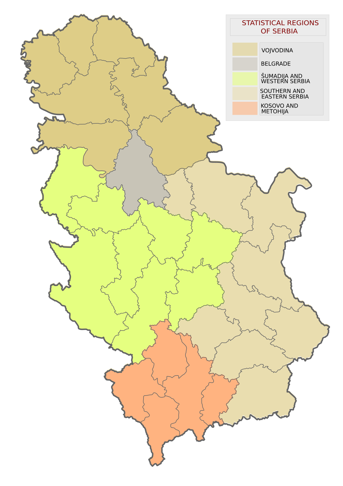
A comprehensive understanding of Serbia comes from exploring its diverse regions, each clearly demarcated on a political map. Imagine viewing a map where distinct lines outline these areas.
Vojvodina
The Northern Plains: Located in the north, this autonomous province is easily identified on a political map by its northern boundary. It's characterized by its vast, fertile plains, part of the Pannonian Basin, historically a breadbasket of Europe. Key features often highlighted include:
Major cities:
- Novi Sad: Serbia's cultural and economic hub.
- Subotica: Known for its stunning Art Nouveau architecture.
- Zrenjanin: A key industrial center.
The relatively flat terrain, ideal for agriculture, contrasting with the low-lying, forested hills of Fruška Gora National Park. On a physical map, Fruška Gora would appear as an area of gentle elevation, dotted with historical Orthodox monasteries, showcasing a blend of natural beauty and spiritual heritage.
Belgrade
The Capital Confluence: Situated centrally at the strategic meeting point of the Sava and Danube rivers, the capital city is clearly marked on all maps, often with a larger font and symbol indicating its national significance. Detailed city maps would show its urban sprawl, the historic Kalemegdan Fortress overlooking the rivers, and the modern business districts that drive Serbia's economy.
Šumadija And Western Serbia
Rolling Hills and Heritage: This central and western part appears geographically diverse on topographic maps, featuring rolling hills, fertile valleys, and numerous orchards, reflecting its agricultural importance and traditional Serbian character. Key aspects include:
Important historical cities like Kragujevac (the first capital of modern Serbia) and Užice (a significant regional center with a rich industrial past).
The dramatic Tara National Park, with its deep river gorges carved by the Drina River, stands out on physical maps as a rugged, mountainous area of exceptional natural beauty and biodiversity.
Southern And Eastern Serbia
Rugged Terrain and Ancient History: This region, characterized by the Carpathian and Balkan mountain ranges visible on physical maps, presents a more rugged landscape, rich in mineral resources and with a distinct cultural heritage influenced by its proximity to Bulgaria and North Macedonia. Notable features include:
Historically significant cities like Niš (the birthplace of Roman Emperor Constantine the Great) and Leskovac (known for its annual barbecue festival).
Diverse terrain, from fertile river valleys suitable for agriculture to high peaks offering opportunities for hiking and skiing, evident on maps showing elevation and land cover.
Kosovo And Metohija
A Region of Contested Status: This autonomous province in the south has its own distinct internal boundaries on political maps. Its geographical features include:
The fertile plains of Metohija, historically significant for agriculture, and the more mountainous areas of Kosovo proper, rich in mineral deposits.
Key cities like Priština (the capital of Kosovo) and Prizren (known for its Ottoman-era architecture). Maps may vary in their representation of Kosovo, with Serbian maps typically showing it as an integral part, while international maps or maps from Kosovo may depict it with different boundaries or as a separate entity, reflecting the ongoing political complexities.
Don't Miss Out: Europe Map Countries And The European Union Politics
Types Of Maps Of Serbia
When it comes to understanding Serbia’s geography, a variety of maps can be useful. Below are some of the most common types of maps that offer different perspectives of the country:
1. Political Map
A political mapof Serbia displays the country's administrative boundaries, highlighting its regions, provinces, cities, and neighboring countries. This type of map is crucial for understanding Serbia’s internal divisionsand its geopolitical position in Europe.
Key Features:
- Provinces and Regions: Key provinces like Vojvodina (to the north) and Kosovo and Metohija (to the south) are prominently marked, along with Belgrade, Serbia’s capital, and other major cities like Novi Sad, Niš, and Kragujevac.
- Neighboring Countries: Serbia’s international boundaries with countries like Hungary, Romania, Bulgaria, North Macedonia, Croatia, Bosnia and Herzegovina, and Montenegroare depicted.
- Municipalities: This map also helps to identify smaller local administrative units, such as municipalities and towns.
Purpose: This map is especially useful for understanding the political structure and administrative divisions of Serbia, as well as its relationship with neighboring countries.
Also Check Out: Map Of Romania - Detailed Map With Cities, Regions & Attractions
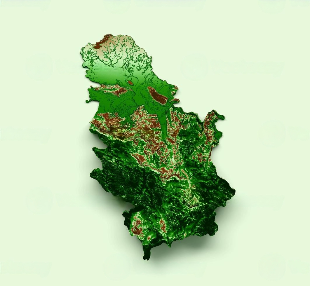
2. Physical Map
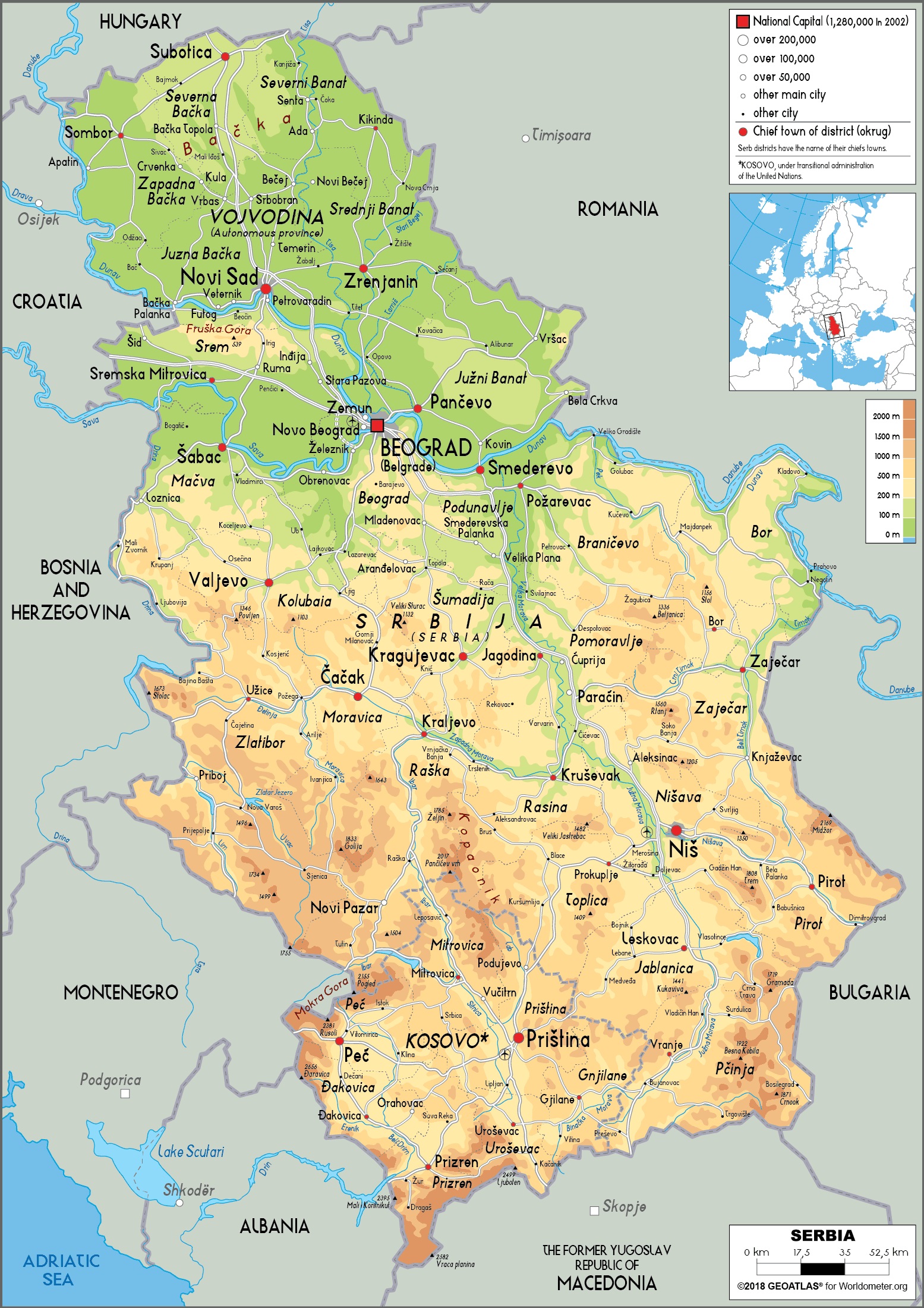
A physical map of Serbia highlights the country’s natural features, providing a clear view of its landforms, rivers, mountains, forests, and plains. It emphasizes the topography and geological features that define Serbia’s diverse landscape.
Key Features:
- Mountains and Hills: Serbia is home to several mountain ranges, including the Carpathian Mountains in the northeast and the Balkan Mountains in the south. Major peaks such as Midžor in the Stara Planina and the Tara National Park are highlighted.
- Rivers: Key rivers, including the Danube, Sava, and Morava, are clearly marked. These rivers play an important role in Serbia’s ecosystem and transportation network.
- Plains: The Pannonian Plain in the north, which is rich in fertile soil and agriculture, is shown.
- Forests and Green Areas: Serbia has vast forests, particularly in the central and southern regions, like the Fruška Gora National Park and the Tara National Park.
Purpose: A physical map helps to visualize the natural landscape of Serbia, offering insight into its ecological diversity and physical features that shape human activity.
3. Topographic Map
A topographic mapof Serbia provides detailed information about the elevation, landforms, and terrain featuresof the country. These maps often use contour lines and shading to show elevation changes, making them highly useful for understanding the topographyof the land.
Key Features:
- Elevation: The use of contour lines helps to highlight mountain ranges, valleys, and plateaus across Serbia. The Balkan Mountainsand the Šumadija Hillsare particularly well-detailed.
- Rivers and Lakes: Water bodies such as the Danube, Sava, Tisa, and Lake Palićare shown in greater detail.
- Detailed Terrain: Forests, plains, and agricultural areasare represented with topographic precision.
- Geological Features: Some topographic maps may include information about Serbia’s mineral depositsand earthquakeszones.
Purpose: These maps are most beneficial for anyone involved in activities such as hiking, land surveying, and environmental studies, as they provide precise details about terrain elevation, slopes, and land cover.
4. Road Map
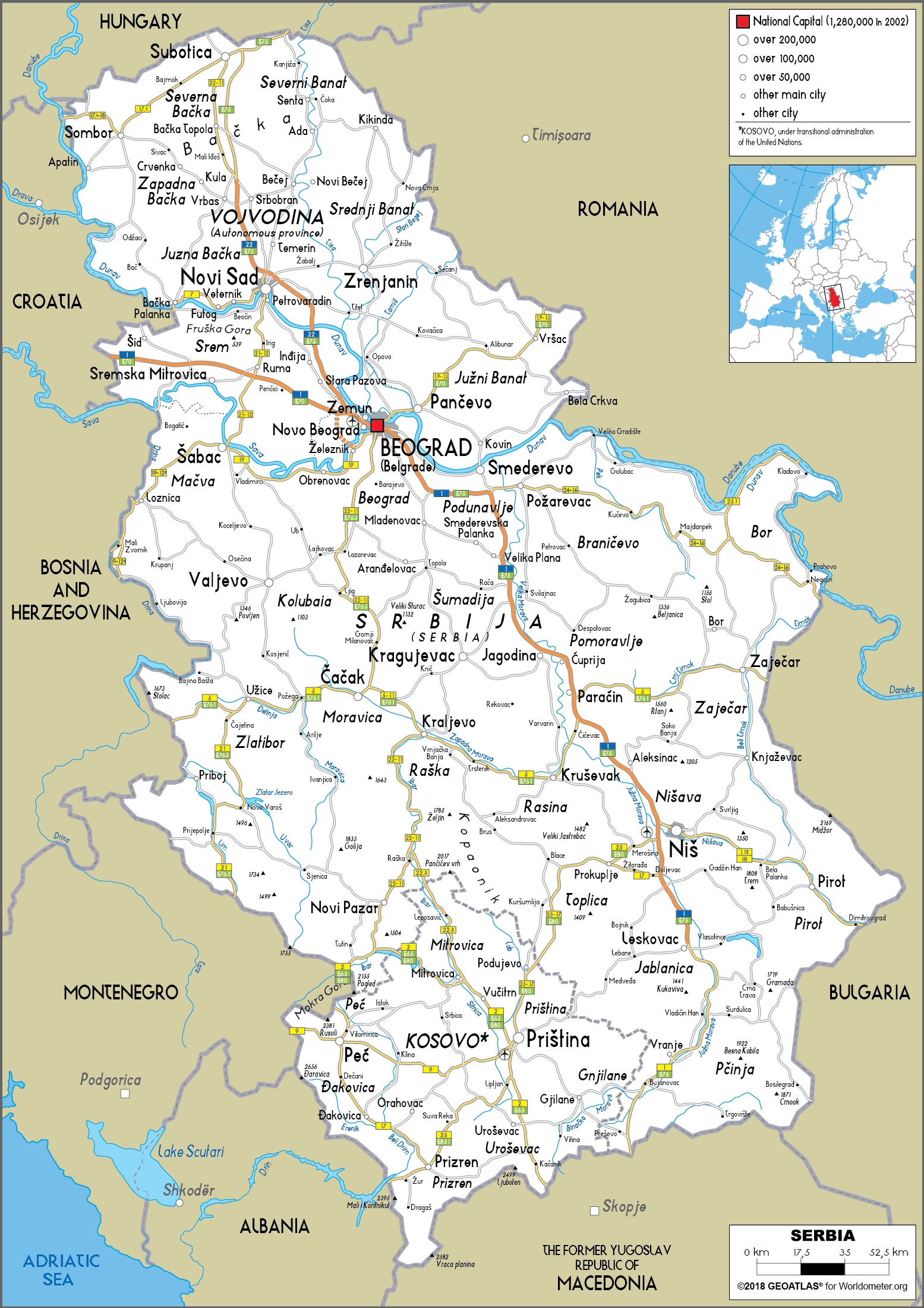
A road mapof Serbia is essential for travelers and drivers navigating the country’s extensive road network. The map highlights major highways, national roads, and local routes, offering clear guidance for both domestic and international travelers.
Key roads include the E-75, which runs from the northern border with Hungary to the southern border with North Macedonia, and the E-70, which crosses Serbia from west to east, connecting major cities such as Belgrade, Novi Sad, and Niš. Serbia’s well-maintained road infrastructure makes it an ideal destination for road trips, with easy access to both rural and urban areas.
Key features of the road map:
- Highways and motorways: Serbia’s motorway system is modern and connects major cities and regions, such as Belgrade, Novi Sad, and Niš.
- Local roads: Smaller, regional routes that connect villages, towns, and natural attractions.
- Border crossings: Important for those traveling into and out of Serbia from neighboring countries.
5. Locator Map
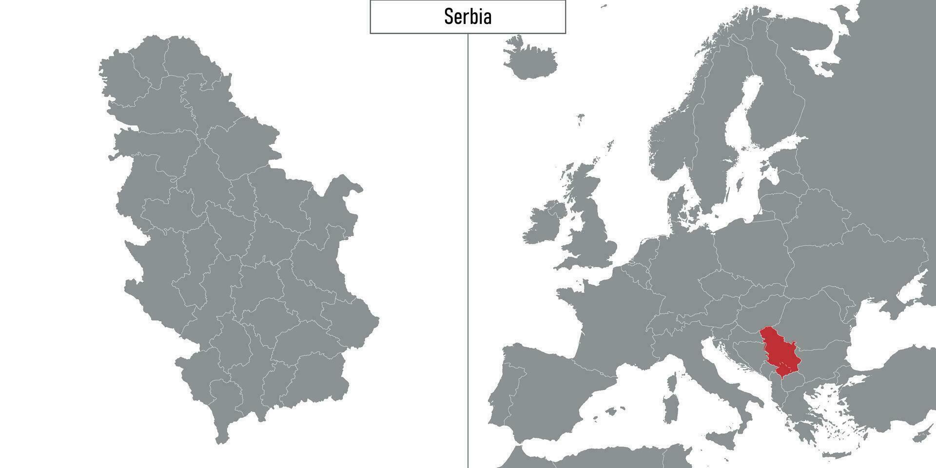
A locator mapserves as an overview of Serbia’s location within Europe, showing its position in relation to neighboring countries and major European cities. This map helps international travelers understand where Serbia fits into the broader context of the European continent. It’s a useful reference for those planning their journey to and from Serbia or interested in learning more about the country’s regional connections.
6. Tourist Map Of Serbia
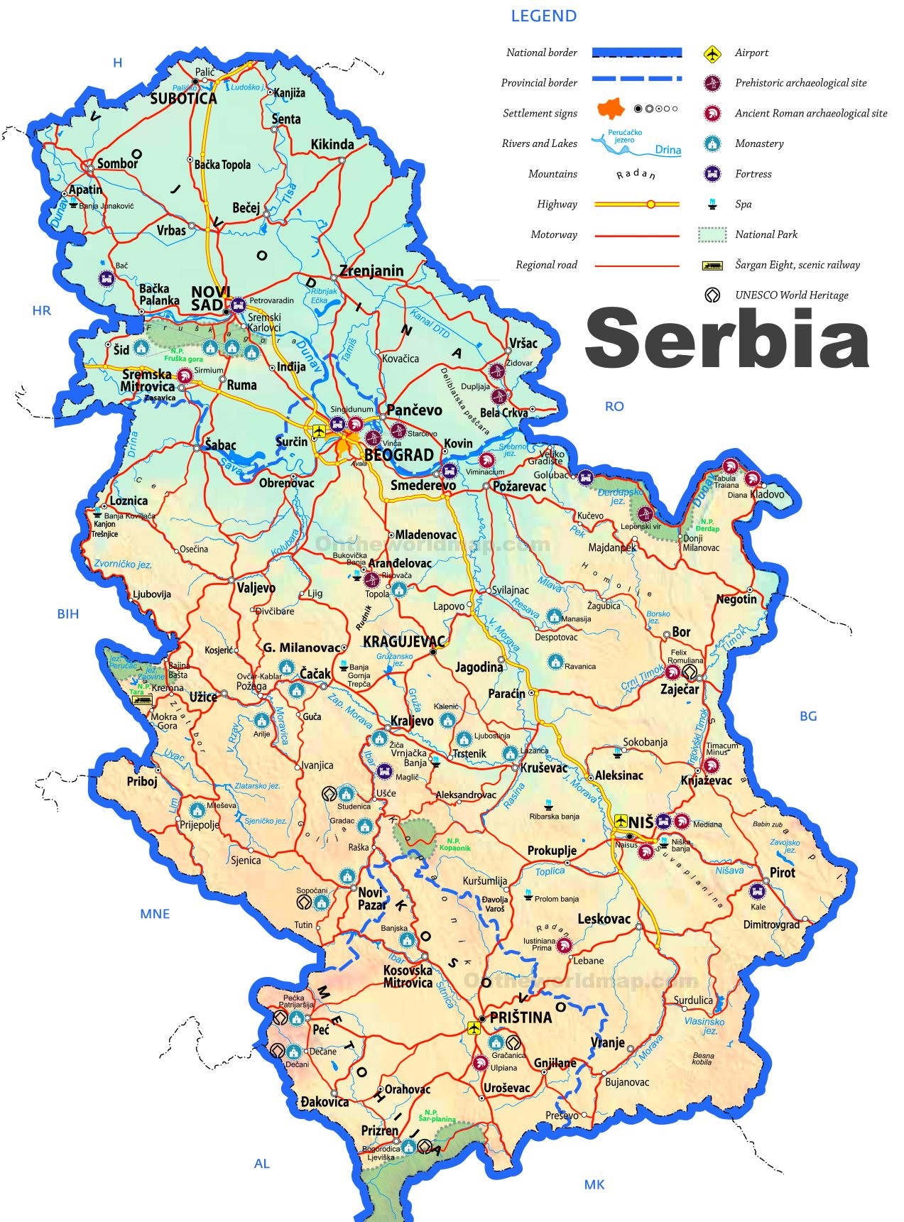
A tourist mapof Serbia is tailored to visitors who wish to explore the country's historical landmarks, natural wonders, and cultural hotspots. This type of map emphasizes points of interest such as UNESCO World Heritage sites, national parks, historic cities, and festivals.
Notable attractions featured on tourist maps include:
- Belgrade: Key landmarks like Kalemegdan Fortress, Saint Sava Temple, and the bohemian district of Skadarlija.
- Novi Sad: The Petrovaradin Fortress, Exit Festival location, and other cultural sites along the Danube River.
- Niš: Historical sites such as the Niš Fortress and the birthplace of Constantine the Great.
- National Parks: Tara National Park, Kopaonik, and the natural reserves offering hiking, skiing, and ecotourism opportunities.
Tourist maps may also indicate local accommodations, restaurants, and transportation options for easier navigation.
7. Thematic Maps
Thematic mapsof Serbia focus on specific aspects such as population density, agricultural regions, economic activities, and historical landmarks, offering in-depth insights into the country’s societal and economic characteristics.
Serbia's Strategic Location In The Balkans: A Map-Based Perspective
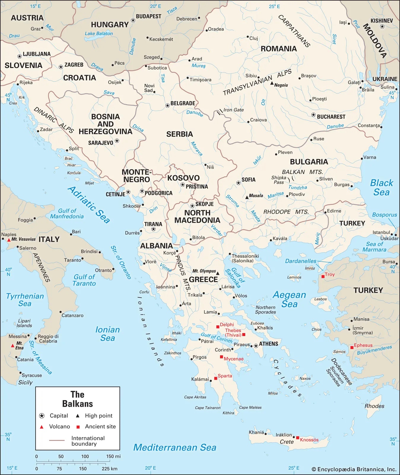
Serbia's geographical position, central to the Balkan Peninsula as clearly shown on maps of Southeast Europe, has profoundly shaped its history and continues to influence its geopolitical significance.
A Bridge Between East And West: The Arteries Of Trade
Maps clearly illustrate Serbia's role as a land bridge. The Morava and Vardar river valleys have historically served as natural corridors connecting Central Europe with the Aegean Sea. The Danube and Sava rivers, major European waterways traversing Serbia, are vital for trade and connectivity, a fact emphasized on transportation maps showing major ports and shipping routes.
Bordering Multiple Nations
An Intricate Network:Serbia's numerous borders with:
- Montenegro (southwest): These numerous and often historically significant borders are evident on any political map of the region, highlighting its central position and the complexity of its regional relationships and historical interactions.
- Hungary (north)
- Romania (east)
- Bulgaria (east)
- North Macedonia (south)
- Croatia (west)
- Bosnia and Herzegovina (west)
The Danube Corridor: A Lifeline On The Map
The Danube River, flowing through northern Serbia, is a crucial feature on European maps, serving as a vital artery for trade, transportation, and cultural exchange.
Serbia's control over significant stretches of this waterway, including the impressive Iron Gate gorge on the Romanian border (a visually striking geographical feature on satellite maps), has considerable economic and strategic implications, influencing navigation and resource management.
Geopolitical Crossroads: A Focal Point On The Map
Serbia's location makes it a focal point for various geopolitical interests, as seen on maps illustrating historical spheres of influence in the Balkans and contemporary geopolitical analyses. Its position between major European powers and its historical ties to both East and West continue to make it a strategically important nation in the region.
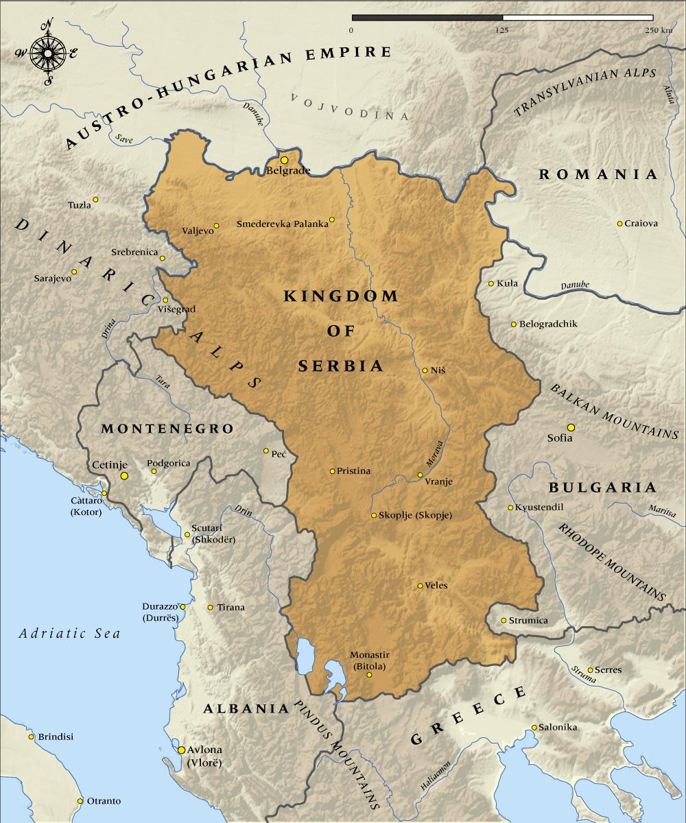
A Journey Through Serbia's Historical Maps
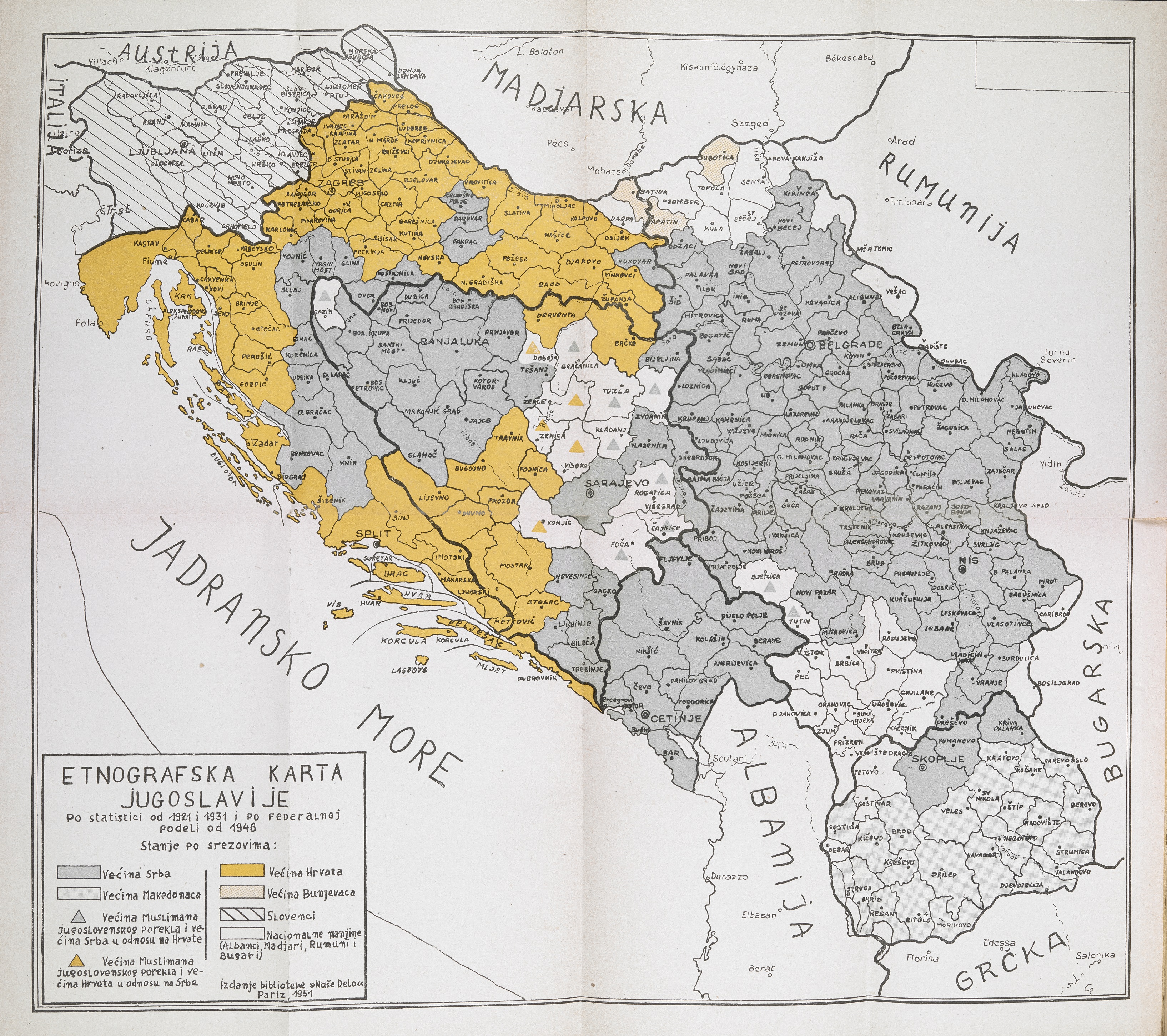
Exploring historical maps of Serbia, often available in online collections and archives, offers a fascinating glimpse into the country's ever-evolving borders and regional configurations, reflecting centuries of shifting empires, conflicts, and political realignments.
Medieval Kingdoms And Empires
Maps from this period showcase the territorial extent of powerful Serbian kingdoms and the Serbian Empire under rulers like Stefan Dušan, illustrating their significant influence across the Balkans and their interactions with neighboring Byzantine and other European powers.
Ottoman And Habsburg Influence
Later maps reveal the impact of centuries of Ottoman rule across much of Serbia, leading to significant administrative and territorial changes. Simultaneously, maps also depict the expansion of the Habsburg Empire into the northern territories of Vojvodina, creating a distinct cultural and political frontier.
The Formation Of Yugoslavia
20th-century maps illustrate the unification of Serbia with other South Slavic peoples after World War I to form the Kingdom of Serbs, Croats, and Slovenes (later Yugoslavia), showcasing a dramatic redrawing of the Balkan map and the creation of a new multi-ethnic state. Subsequent maps would detail the internal administrative divisions of Yugoslavia throughout its various phases.
The Breakup And Modern Serbia
Contemporary historical maps document the violent fragmentation of Yugoslavia in the 1990s and the eventual emergence of modern-day Serbia within its current internationally recognized borders following the dissolution of the state union with Montenegro in 2006, highlighting a period of significant geopolitical upheaval and the redrawing of national boundaries in the Western Balkans.
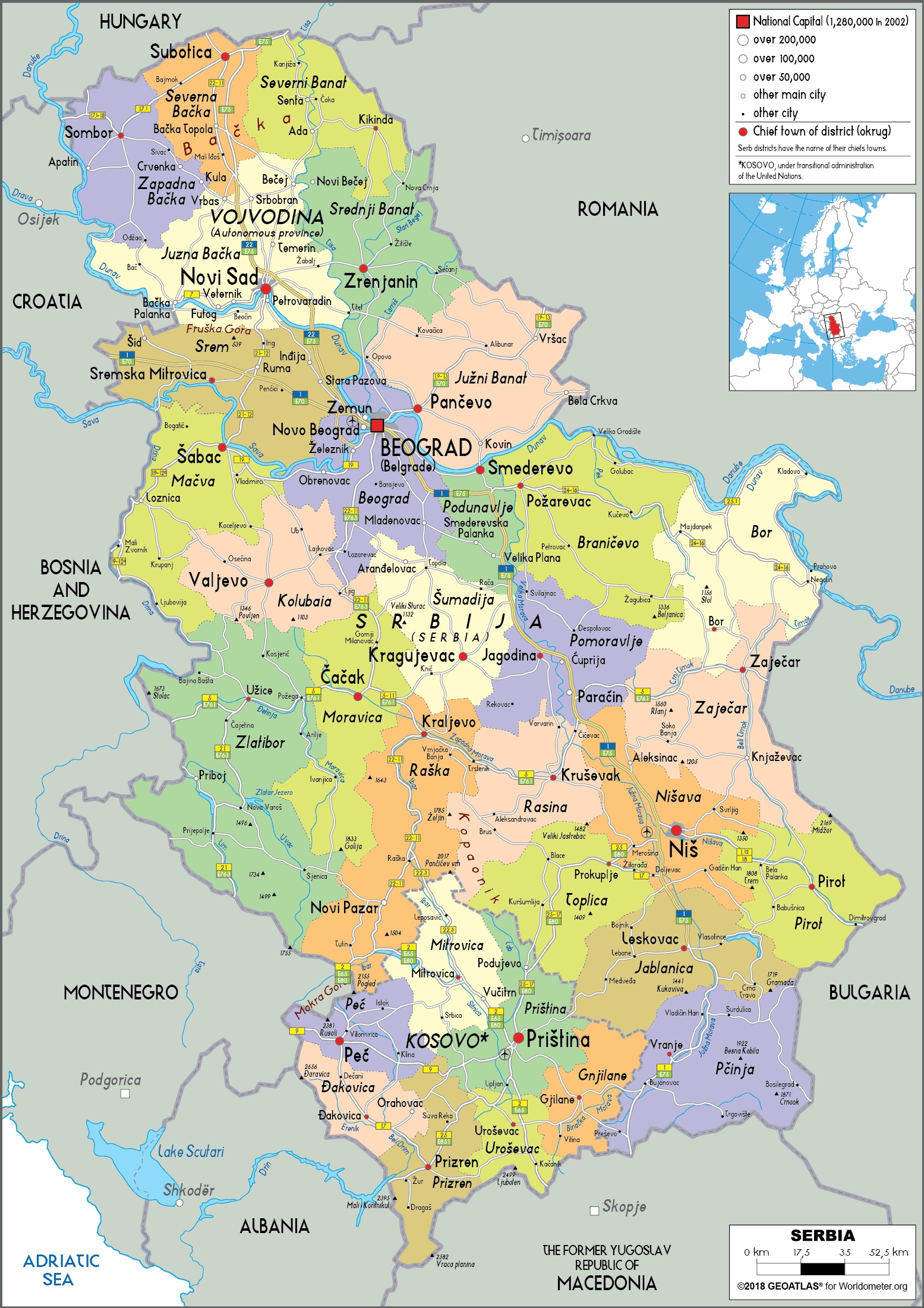
Administrative Map Of Serbia: Districts, Cities, And Municipalities
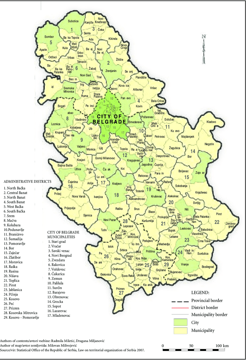
Serbia is divided into several administrative units that are crucial for governance, regional planning, and demographic analysis. An administrative map outlines these divisions, showing how the country is structured internally.
Administrative Divisions
- Districts (Okrugi): Serbia is divided into 29 districts, including the City of Belgrade, which has a special administrative status. Districts serve as regional centers for state authorities.
- Municipalities (Opštine): There are over 140 municipalities, each responsible for local services, urban planning, and governance.
- Cities (Gradovi): Larger urban areas, like Novi Sad, Niš, and Kragujevac, are designated as cities and typically consist of several municipalities.
Key Administrative Highlights
- Belgrade: The capital has its own city administration and includes 17 municipalities.
- Vojvodina: The autonomous province in the north includes 7 districtsand showcases significant ethnic and cultural diversity.
- Kosovo and Metohija: Serbia officially considers it an autonomous province, though it declared independence in 2008 and operates under a separate administration.
Administrative maps are essential for understanding how services, elections, and infrastructure are managed across Serbia.
Major Cities And Landmarks In Serbia
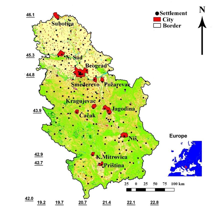
While the administrative map helps visualize Serbia’s internal structure, this section explores the cultural, historical, and tourism highlightsof its most prominent cities. Each city offers a window into Serbia’s rich heritage and modern vitality.
Belgrade
Serbia’s capital is a city of contrasts, where history meets nightlife. It lies at the confluence of the Sava and Danube Rivers and has been a strategic center since Roman times.
- Landmarks: Kalemegdan Fortress, Saint Sava Temple, Republic Square
- Culture: Vibrant café scene, museums, and a mix of Ottoman, Austro-Hungarian, and Brutalist architecture
Novi Sad
The second-largest city sits on the Danube’s banks and serves as a cultural hub, especially during the summer.
- Famous for: Petrovaradin Fortress, Exit Music Festival
- Attractions: Danube Park, Museum of Vojvodina, Štrand Beach
Niš
One of the oldest cities in Europe, Niš has deep Roman roots and Ottoman influence.
- Historical Sites: Niš Fortress, Skull Tower, and Mediana
- Significance: Birthplace of Constantine the Great
Kragujevac
Located in central Serbia, Kragujevac was Serbia’s first modern capital in the 19th century.
- Landmarks: Šumarice Memorial Park, Old Foundry Museum
- Modern Role: Industrial and university city
Subotica
A jewel in northern Vojvodina, known for its stunning Art Nouveau architecture and multicultural spirit.
- Highlights: City Hall, Synagogue, Palić Lake nearby
- Culture: Blend of Hungarian, Serbian, and Croatian heritage
Top Tourist Attractions In Serbia
1. Belgrade - The White City
- One of Europe’s oldest continuously inhabited capitals
- Home to Kalemegdan Fortress, overlooking the Danube and Sava Rivers
- Vibrant nightlife in Skadarlija, the bohemian quarter
- Floating river clubs (splavovi) attract partygoers from across Europe
2. Novi Sad And The Petrovaradin Fortress
- Known for EXIT Festival, one of Europe’s top music festivals
- The 17th-century Petrovaradin Fortressoffers sweeping views of the Danube
- Charming old town with Austro-Hungarian architecture
3. Niš – City Of Emperors
- Birthplace of Roman Emperor Constantine the Great
- Famous for Niš Fortress, Skull Tower, and Ottoman heritage
4. Tara National Park
- One of the most beautiful and biodiverse areas in Serbia
- Home to the Pančić Spruce, a rare endemic tree species
- Popular for hiking, river rafting on the Drina River, and bear watching
5. Studenica Monastery (UNESCO)
- 12th-century Orthodox monastery founded by Stefan Nemanja, Serbia’s medieval founder
- Noted for its Byzantine frescoesand white marble church
6. Đavolja Varoš (Devil's Town)
- Geological wonder with 200+ unique stone pillars formed by erosion
- Often likened to Cappadocia, but lesser known and uncrowded
7. Uvac Canyon And River Meanders
- Breathtaking aerial views of emerald green meanders
- Habitat of the endangered griffon vulture
8. Vrnjačka Banja And Other Spa Towns
- Famous for thermal springs and wellness retreats
- A legacy of Roman and Ottoman spa culture
9. Subotica And Palić Lake
- Known for Art Nouveau architectureand multicultural charm
- Close to Hungary, reflecting Central European influences
10. Iron Gate Gorge (Đerdap National Park)
- One of Europe's most dramatic river gorges along the Danube
- Site of Lepenski Vir, a Mesolithic archaeological site
Top 10 Best Places to Visit in Serbia - Travel Video 2024
Fascinating Facts About Serbia
- Inventor of Electricity’s Future: Nikola Tesla, the world-renowned inventor, was ethnically Serbian and born in modern-day Croatia. Serbia honors him with museums and currency.
- Land of Roman Emperors: 17 Roman emperors were born in what is now Serbia—more than in any other country except Italy.
- No Coastline, but Plenty of Rivers: Serbia is landlocked, yet the Danube, Sava, and Drinarivers provide stunning water landscapes, river cruises, and commerce.
- World’s Most Resilient Church: The Church of Saint Savain Belgrade is one of the largest Orthodox churches in the world-built and rebuilt through wars and political turmoil.
- Underground City: Subterranean Belgrade features hidden tunnels, bunkers, and Roman-era ruins.
- Rich in Natural Springs: Over 1,000 mineral springsexist across Serbia, making it one of the leading spa destinations in Europe.
- Rakija Culture: Serbia’s national drink, rakija(fruit brandy), is often homemade and offered as a gesture of hospitality-even at funerals and weddings.
- Language and Alphabet: Serbian is one of the few languages that uses both Cyrillic and Latin alphabetsinterchangeably.
- Vampire Origins: The word "vampire" originates from Serbian folklore. The first "real" vampire story, Petar Blagojević, comes from a Serbian village in the 18th century.
FAQs About The Map Of Serbia
What Are The Most Prominent Geographical Features Visible On A Map Of Serbia?
The most prominent features include the expansive Pannonian Plain in the north, the winding courses of the Danube, Sava, and Morava rivers, and the imposing mountain ranges of the Dinaric Alps in the west and the Carpathians and Balkans in the east and south.
How Does The Strategic Location Of Serbia, As Seen On A Map, Impact Its International Relations?
Serbia's central position in the Balkans, bordering numerous countries and serving as a historical and contemporary transit route, necessitates complex diplomatic relations and positions it as a key player in regional stability and European integration efforts.
Can Historical Maps Of Serbia Provide Insights Into The Causes Of Modern-day Regional Tensions?
Yes, historical maps illustrate the shifting borders, the influence of past empires, and the formation and dissolution of Yugoslavia, providing crucial context for understanding the complex historical grievances and ethnic dynamics that contribute to current regional tensions.
What Types Of Administrative Information Can Be Found On A Detailed Map Of Serbia?
A detailed administrative map will show the boundaries of Serbia's autonomous provinces, its constituent districts (okruzi), and its numerous municipalities (opštine) and cities (gradovi), providing a clear picture of the country's internal governance structure.
How Do Thematic Maps Enhance Our Understanding Of Serbia Beyond Basic Geographical And Political Information?
Thematic maps overlay specific data onto geographical maps, allowing us to visualize patterns and relationships related to population density, economic activity, resource distribution, environmental factors, and cultural characteristics across Serbia, providing a deeper and more nuanced understanding of the country.
A Quick Recap
The map of Serbia is an indispensable tool for grasping the multifaceted identity of this Balkan nation.
By meticulously exploring its political and physical geography, its intricate administrative structure, and its compelling historical evolution through various cartographic representations, we gain a profound insight into its regional complexities, its enduring strategic significance, and the dynamic interplay between its diverse landscapes and the resilient spirit of its people.
For those seeking even greater detail and interactive exploration, numerous online resources, official government websites, and specialized mapping platforms offer a wealth of maps of Serbia, each providing a unique perspective on this captivating corner of Europe.
Jump to
Quick Facts About Serbia
Overview Of Serbia: Geography And Location
Serbia's Regional Tapestry
Types Of Maps Of Serbia
Serbia's Strategic Location In The Balkans: A Map-Based Perspective
A Journey Through Serbia's Historical Maps
Administrative Map Of Serbia: Districts, Cities, And Municipalities
Major Cities And Landmarks In Serbia
Top Tourist Attractions In Serbia
Fascinating Facts About Serbia
FAQs About The Map Of Serbia
A Quick Recap

Michael Rachal
Author
Michael Rachal believes that luxury lies in the details. With over 20 years of experience in the luxury travel industry, he has crafted hundreds of bespoke itineraries for clients seeking personalized, unforgettable experiences.
Whether guiding clients through private cultural tours or curating culinary journeys with world-renowned chefs, Michael ensures that each trip is tailored to perfection.
His ability to anticipate needs and exceed expectations has earned him a reputation as a leading expert in luxury travel.

Finn Wilde
Reviewer
For Finn Wilde, the wilderness is more than just a destination - it’s a way of life. Over the past decade, he has led multiple expeditions in some of the world’s most remote regions, from the icy fjords of Greenland to the rugged trails of Patagonia.
Finn emphasizes sustainability in all of his adventures, helping participants connect with nature while promoting responsible exploration. His expeditions inspire individuals to explore the great outdoors while fostering a deep respect for the environment.
Latest Articles
Popular Articles