Map Of Malta | Key Cities, Top Attractions And Essential Travel Tips
Plan your Malta journey with ease. Learn about the top attractions, regions, and cities on the map of Malta for an unforgettable experience.
Author:Finn WildeReviewer:Michael RachalOct 20, 202525K Shares342.8K Views
Malta, with its rich history, stunning landscapes, and Mediterranean charm, offers much to anyone interested in its geography and culture. This country is also a sought destination for those interested in opening a business and who need Maltese company incorporationservices from local professionals.
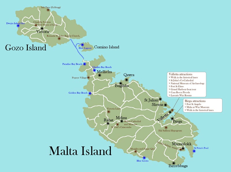
A detailed map of Maltanot only showcases its compact yet diverse landscape but also reveals the unique cities, landmarks, and routes that define this small island nation.
From the bustling streets of Valletta to the tranquil shores of Gozo, understanding the map of Malta can enhance your travelexperience and give you a deeper appreciation of this remarkable archipelago.
Quick Facts
- Population: Approximately 520,000
- Capital: Valletta
- Currency: Euro (€)
- Official Languages: Maltese and English
- Total Area: 316 square kilometers
- Major Islands: Malta, Gozo, Comino
- Timezone: Central European Time (CET)
Geographical Overview Of Malta
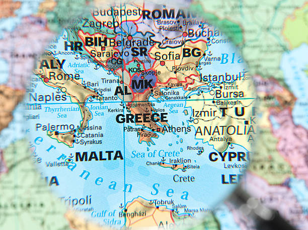
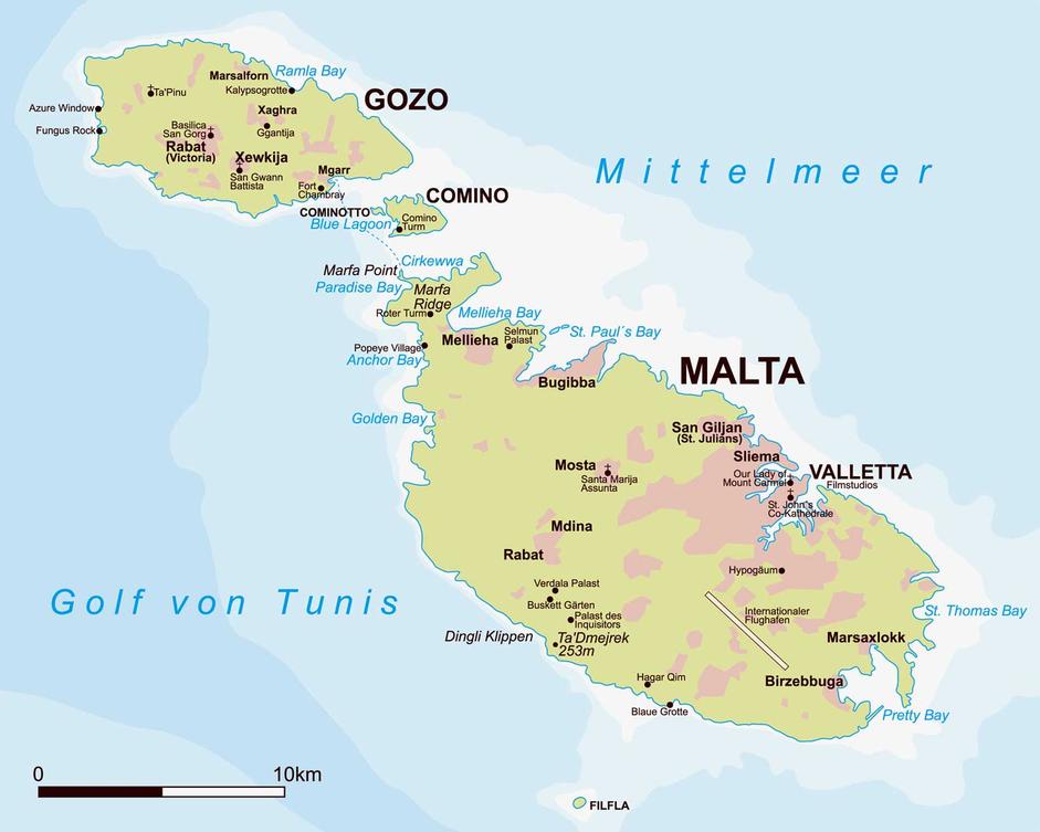
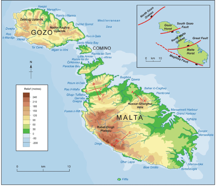
Located strategically in the central Mediterranean, Malta lies south of Italy, north of Libya, and east of Tunisia. The archipelago consists of three main islands: Malta, Gozo, and Comino, along with several smaller uninhabited islands. Malta, the largest island, serves as the country’s political and cultural hub. The total land area of Malta is approximately 316 square kilometers (122 square miles), making it one of the smallest countries in Europe.
Despite its small size, Malta’s geographical location has made it a valuable strategic base throughout history, from the Phoenicians to the Knights of St. John. On a map, Malta appears as a cluster of islands surrounded by the sparkling blue waters of the Mediterranean, with dramatic cliffs along its coastlines and rolling valleys inland. If you’re considering relocating to Malta, understanding the steps to move to a new countrycan help you prepare for a smooth transition.
Capital Of Malta
Valletta, Malta's capital, is not only the administrative and political center but also the heart of the island’s cultural and historical legacy. Established in 1566 by the Knights of St. John, Valletta is a fortified city filled with stunning architecture, museums, and historical landmarks.
Located on the southern coast of the island, Valletta is easily recognizable on any map of Malta due to its narrow peninsula shape, bordered by two harbors Marsamxett Harbour to the west and Grand Harbour to the east.
Map Of Malta Cities
1. Valletta
Valletta is the capital city of Malta and one of the most historically significant locations on the island. It is a UNESCO World Heritage site, known for its stunning Baroque architecture and rich military and cultural history. Valletta was built by the Knights of St. John in the 16th century, and it serves as the administrative, cultural, and commercial heart of the country.
- Attractions:St. John’s Co-Cathedral, the Grand Master's Palace, the Upper Barracca Gardens, and the National Museum of Archaeology.
- Significance:As the political and administrative center, Valletta is home to the Maltese Parliament and many important governmental buildings.
2. Birkirkara
Birkirkara is the largest city in Malta by population, located just inland from Valletta. It is known for its suburban character, blending residential areas with a rich history and cultural heritage. Birkirkara has many churches, historical buildings, and landmarks, reflecting its long-standing role in Maltese life.
- Attractions:The Church of St. Helen, the Parish of Birkirkara, and the nearby Villa Frere.
- Significance:Birkirkara is one of Malta’s oldest cities and is often considered the heart of Maltese culture.
3. Mdina
Mdina is the ancient capital of Malta, often referred to as the "Silent City." This fortified city, perched on a hilltop in the center of the island, offers a glimpse into Malta’s medieval past. The city's narrow, winding streets and stunning architecture make it a popular tourist destination.
- Attractions:St. Paul's Cathedral, the Mdina Dungeons, and the Mdina City Walls.
- Significance:Mdina served as Malta’s capital until the 16th century and remains a prime example of medieval and Baroque architecture.
4. Sliema
Sliema is a bustling city located on the northern coast of Malta, known for its modern lifestyle, shopping areas, and seaside promenade. It is a popular area for both locals and tourists, offering a mix of restaurants, cafes, and luxury hotels.
- Attractions:The Sliema promenade, the Tigné Point shopping center, and the Fort Tigné.
- Significance:Sliema is one of Malta’s primary commercial and residential centers and is known for its vibrant nightlife.
5. St. Julian's
St. Julian’s, located just a short distance from Sliema, is Malta’s entertainment hub. Known for its vibrant nightlife, luxury hotels, and restaurants, it is also a popular destination for young tourists. The town has a rich history and has evolved from a small fishing village to one of the island's most lively urban areas.
- Attractions:Spinola Bay, Portomaso Marina, and the nightlife in Paceville.
- Significance:St. Julian’s is synonymous with entertainment, catering to tourists and locals alike with a wide array of dining, bars, and clubs.
6. Rabat
Rabat, adjacent to Mdina, is a town rich in history and culture. Rabat is known for its historical buildings and the proximity to significant archaeological sites, such as the catacombs. It is a quieter town compared to the bustling cities of Valletta and Sliema but offers visitors a deep dive into Malta’s history.
- Attractions:St. Paul’s Catacombs, the Domus Romana, and the Wignacourt Museum.
- Significance:Rabat is a vital cultural center with ties to Malta’s Roman past, serving as an important residential area during ancient times.
7. Marsa
Marsa is a small city located near the capital, Valletta. While it is primarily an industrial and commercial area, Marsa has historical significance and offers a glimpse into Malta’s maritime past. The city is often considered a gateway to Malta’s dockyards and is home to the Marsa Sports Club. Marsa is also an excellent option for those seeking budget travel destinationsdue to its affordability compared to more tourist-heavy areas of the island.
- Attractions:The Marsa Sports Club, the Marsa Open Air Theatre, and the nearby Malta Freeport.
- Significance:Marsa’s role in Malta’s industrial growth and maritime history makes it a key part of the island’s economy.
8. Floriana
Floriana is located just outside of Valletta and was built as a suburb to the capital city. It features wide, tree-lined avenues and public gardens, providing a peaceful escape from the bustling capital. Floriana is also home to several important government buildings and historical sites.
- Attractions:The Lower Barracca Gardens, the Church of the Immaculate Conception, and the Floriana Granaries.
- Significance:Floriana has played a key role in the defense of Valletta, serving as the site of several military fortifications.
9. Zejtun
Zejtun is a historic town in the southern part of Malta, known for its peaceful rural character. It is one of Malta’s oldest towns, with a history dating back to Roman times. Zejtun is famous for its traditional architecture and agricultural heritage.
- Attractions:The Church of St. Catherine, the Zejtun Windmill, and several beautiful countryside walking trails.
- Significance:The town’s rural atmosphere and agricultural traditions provide a contrast to the more urbanized areas of Malta.
10. Birgu (Vittoriosa)
Birgu, also known as Vittoriosa, is one of the three cities of the Grand Harbour and is rich in history, particularly from the time of the Knights of St. John. The city played a central role in Malta’s defense during the Great Siege of 1565 and remains a major historical and cultural site.
- Attractions:Fort St. Angelo, the Inquisitor's Palace, and the Malta Maritime Museum.
- Significance:Birgu was the first city to be inhabited by the Knights of St. John and served as their headquarters before Valletta was constructed.
11. Luqa
Luqa is a small town located in the southern part of Malta. It is most well-known for being the location of the Malta International Airport, the island’s main international gateway. Despite its relatively small size, Luqa is historically significant and has a variety of traditional Maltese architecture.
- Attractions:The Parish Church of St. Andrew and several historical buildings dating back to the British era.
- Significance:Luqa's strategic location near the airport makes it an important hub for transportation on the island.
12. Gozo
Gozo is an island off the coast of Malta and is considered a separate entity, although it is often referred to as a city. Known for its natural beauty, slower pace of life, and historical sites, Gozo is a popular destination for tourists seeking a more relaxed environment compared to the main island of Malta.
- Attractions:The Ġgantija Temples, the Citadel, and the Azure Window (now collapsed).
- Significance:Gozo is Malta’s second-largest island and holds a special place in Maltese history, with its Neolithic temples being among the oldest freestanding structures in the world.
Regions On The Map Of Malta
1. Northern Region
The Northern Region of Malta is known for its tranquil atmosphere, scenic beaches, and coastal views. This region is perfect for travelers seeking outdoor activities, relaxation, and nature reserves. It includes some of the island's most popular beach resorts and charming towns.
- Key Locations:Mellieħa, St. Paul’s Bay, Bugibba, Qawra
- Highlights:Mellieħa Bay is one of Malta's largest sandy beaches, ideal for swimming and water sports. The nearby Għadira Nature Reserve offers walking trails and a rich variety of birdlife. St. Paul’s Bay, known for its clear waters, is a favorite spot for diving and snorkeling.
- Significance:The northern region is also home to the historic Popeye Village, a theme park created from the set of the 1980 film Popeye, and the quiet village of Mellieħa, which boasts beautiful panoramic views of the Mediterranean.
2. Southern Region
The Southern Region of Malta is characterized by its rugged landscapes, fishing villages, and ancient historical sites. This area provides a contrast to the bustling tourist spots of the north and offers a more authentic, traditional Maltese experience.
- Key Locations:Marsaxlokk, Ħaġar Qim, Mnajdra, Birzebbuga
- Highlights:The fishing village of Marsaxlokk is famous for its colorful boats, traditional markets, and fresh seafood restaurants. The region is also home to the megalithic temples of Ħaġar Qim and Mnajdra, which are among the oldest free-standing structures in the world. The Blue Grotto, a stunning sea cave, is also located nearby.
- Significance:This region is perfect for travelers looking to experience Malta's ancient history and natural beauty, with numerous archaeological sites and scenic coastal views.
3. Central Region
The Central Region of Malta is the island's cultural and historical heart. This region includes the capital city, Valletta, along with other significant towns like Birkirkara and Mosta, making it ideal for those interested in history, art, and Maltese traditions.
- Key Locations:Valletta, Birkirkara, Mosta, Floriana
- Highlights:Valletta, a UNESCO World Heritage site, is known for its impressive Baroque architecture, St. John’s Co-Cathedral, and the Grand Master's Palace. Mosta is home to the famous Mosta Dome, a church with one of the largest unsupported domes in the world. The central region also features Floriana, with its lush public gardens and historical fortifications.
- Significance:As the cultural hub of the island, the Central Region is rich in museums, churches, and historical landmarks. It offers a blend of modern life and deep-rooted history, making it a must-visit for those wanting to explore Malta’s heritage.
4. Western Region
The Western Region of Malta is known for its natural beauty, picturesque landscapes, and tranquil villages. This area is less crowded than other parts of the island, offering visitors a peaceful retreat with a blend of rural charm and coastal views.
- Key Locations:Rabat, Dingli, Mġarr, and Għarb
- Highlights:Rabat, known for its Roman and medieval heritage, is home to the St. Paul’s Catacombs and the Mdina Old City. The Dingli Cliffs provide breathtaking panoramic views of the Mediterranean, and Mġarr offers access to the picturesque Gozo Ferry Terminal.
- Significance:The Western Region is perfect for nature lovers, history enthusiasts, and those looking for a quiet getaway away from the more tourist-heavy areas.
Population Of Malta
Malta has a population of approximately 520,000 people, making it one of the most densely populated countries in the world. The majority of Malta's population resides on the main island, particularly in urban areas like Valletta, Sliema, and Birkirkara. Malta's small land area combined with its high population density makes it an interesting study in urban planning and infrastructure.
From a map perspective, the population concentration is clear, with the majority of settlements located along the coasts and in the central region. The islands of Gozo and Comino are less densely populated, with Gozo being the second most populated island.
Dialing Code Of Malta
Malta’s international dialing code is +356. This is used when dialing from abroad, and it’s a good idea to keep this code in mind if you plan to make local calls during your visit.
Currency Of Malta
Malta is part of the European Union, and the official currency is the Euro (€). Visitors from other EU countries will find it easy to use their own currencies, but travelers from non-Eurozone countries should be prepared to exchange their money for Euros when arriving.
Language Of Malta
Malta has two official languages, Malteseand English. Both languages play an integral role in the country’s daily life, culture, and administration.
Maltese (Il-L-Ilsien Malti)
Maltese, known as Il-L-Ilsien Maltiin the local language, is the national language of Malta. It is a unique Semitic language with strong influences from Romance languages, particularly Italian and Sicilian, due to the country’s historical connections with Italy and other Mediterranean powers. Maltese is the only official Semitic language in the European Union and is used in government, media, and everyday communication.
- Origins:Maltese developed from a blend of Arabic dialects brought to the island by the Arabs in the 9th century, combined with Romance influences that began with Norman and Sicilian rule.
- Writing System:The language uses the Latin alphabet, making it accessible for speakers of other European languages, although it includes additional letters such as “Ħ” and “Ċ”.
- Usage:While Maltese is the language most commonly spoken at home and in informal settings, it is also used in formal settings, such as legislation and religious ceremonies.
English
English has been widely spoken in Malta since British colonial rule, which lasted from 1800 to 1964. It remains one of the two official languages of the country, alongside Maltese, and is the primary language for business, education, and tourism.
Flag Of Malta
Malta’s flag is a symbol of its rich history and sovereignty. It consists of two vertical bands white on the hoist side and red on the fly side. The flag features the George Cross, awarded to the Maltese people by the British King George VI in 1942 for their bravery during World War II.
Total Area Of Malta
Malta’s total area is approximately 316 square kilometers, making it one of the smallest countries in the world. Its size is evident when viewing it on a map, with the main island being just 27.3 kilometers long and 14.5 kilometers wide.
Despite its small size, Malta boasts a diverse range of landscapes, including rocky cliffs, sandy beaches, rolling hills, and bustling urban areas. The smaller islands of Gozo and Comino add to the total area but are much less developed compared to the main island.
Major Routes And Highways
1. Coast Road (Mellieħa To Marsaskala)
The Coast Road, also known as the SPB (San Pawl il-Baħar) Coast Road, runs from the northern part of Malta in Mellieħa all the way down to Marsaskala in the south. This major route is one of the island's most scenic, offering beautiful views of the Mediterranean coast.
- Significance:The Coast Road is essential for connecting the northern and southern regions of the island. It provides access to popular beaches, including Golden Bay and Għajn Tuffieħa, making it a key route for tourists.
- Experience:The route offers stunning coastal views, and it’s frequently used by both locals and tourists traveling to coastal attractions. The road is also lined with hotels, restaurants, and resorts.
2. Valletta To Sliema Road (Triq Il-Kbira)
This busy route connects the capital city, Valletta, to Sliema, one of Malta's main urban areas. The road is heavily used for both local commuting and by tourists heading to the popular shopping and entertainment district of Sliema.
- Significance:The Valletta to Sliema route is vital for accessing two of the most visited areas in Malta. Valletta is the cultural heart of the island, while Sliema is a hub for shopping, dining, and nightlife.
- Experience:Travelers can easily access both historical sites in Valletta and the vibrant waterfront areas of Sliema. This road is also the route for public transport, including ferries connecting Sliema and Valletta.
3. Marsa To Attard Road (Triq Il-Marsa)
The Marsa to Attard Road is a key route that connects the central area of Marsa with the town of Attard, a central region of Malta. This route plays a significant role in connecting Malta's main urban areas.
- Significance:This road is one of the busiest in Malta and serves as an important route for reaching various suburban areas. It is also close to the Ħal Saflieni Hypogeum, a UNESCO World Heritage site, making it a frequently used road for tourists.
- Experience:The road passes through both industrial and residential areas, offering a contrast to the island’s more tourist-oriented routes. It is a major commuter route for locals.
4. Mġarr To Cirkewwa Road (SPB Road)
The Mġarr to Cirkewwa Road, also known as SPB Road, connects the northernmost point of Malta to the ferry terminal at Cirkewwa, where ferries to Gozo depart.
- Significance:This road is vital for tourists traveling to Gozo, one of Malta’s sister islands. The Cirkewwa ferry terminal is the main point for travelers to access the island of Gozo, so this route is regularly used by both locals and visitors.
- Experience:The drive along this route offers scenic views of the island's northern coast, with lush countryside and small towns along the way.
5. Marsaxlokk To Birzebbuga Road (Triq Marsaxlokk)
This road connects the coastal town of Marsaxlokk with the nearby town of Birzebbuga. Marsaxlokk is famous for its picturesque harbor, seafood markets, and colorful fishing boats, while Birzebbuga offers access to the popular Pretty Bay.
- Significance:The Marsaxlokk to Birzebbuga Road is important for those traveling to these two seaside towns. Marsaxlokk is a major tourist attraction, particularly on Sundays when the fish market is at its peak.
- Experience:This route allows travelers to pass through the tranquil fishing villages of Malta, offering a relaxed atmosphere and beautiful views of the coast. The road is also close to the St. Peter’s Pool, a natural swimming area.
6. Għajnsielem To Victoria Road (Gozo)
The Għajnsielem to Victoria Road is a significant road in Gozo that connects the port town of Għajnsielem with the island's capital, Victoria. It is the main thoroughfare for anyone traveling from the ferry terminal at Mgarr to the central hub of Gozo.
- Significance:This route is crucial for locals and visitors who are traveling to Victoria, which is home to many of Gozo’s historical landmarks, including the Citadel.
- Experience:The road passes through charming Gozitan villages, and visitors can enjoy views of the island’s lush hills and countryside while traveling.
7. Birkirkara To Luqa Road (Triq Il-Luqa)
The Birkirkara to Luqa Road connects the central town of Birkirkara to Luqa, a town located near Malta’s international airport. This is a primary road for those heading to and from Malta International Airport (MLA).
- Significance:This route is vital for travelers arriving or departing Malta, as it leads directly to the airport. It is also used by locals heading to the southern parts of the island.
- Experience:This road is often busy, especially during rush hours, but it offers easy access to the airport and other areas like the town of Paola and the nearby Tarxien Temples.
8. Rabat To Mgarr Road (Gozo)
The Rabat to Mgarr Road is located in Gozo and connects the town of Rabat (near the Citadel) to the Mgarr port, where ferries from Malta arrive.
- Significance:This route is essential for both locals and tourists who are traveling between Gozo’s key inland attractions and the ferry terminal.
- Experience:The route passes through rural Gozo, offering scenic views of fields and hills. It’s often used by visitors heading to the beaches on the island’s northern coastline.
9. Qormi To Żebbuġ Road (Triq Il-Qormi)
The Qormi to Żebbuġ Road connects the towns of Qormi and Żebbuġ in the central region of Malta. It is one of the primary routes in this densely populated area.
- Significance:This road is essential for local traffic and provides access to residential and commercial areas in the region. Qormi is known for its baking heritage, while Żebbuġ is a gateway to nearby rural areas.
- Experience:The road runs through Malta’s heartland, passing through both urban and suburban areas. Travelers can stop in local cafes and shops along the way.
10. Xgħajra To Marsascala Road (Triq Il-Qajjenza)
This road connects the seaside village of Xgħajra to Marsascala, another popular coastal town. The route is primarily used by locals but is also important for visitors traveling between these two picturesque villages.
- Significance:This road offers access to both peaceful coastal areas and various local shops and eateries. The route is used by those traveling to beaches like St. Thomas Bay and the surrounding natural areas.
- Experience:The drive along this road offers a more serene side of Malta, with views of quiet beaches and traditional Maltese villages.
Types Of Maps Of Malta
Maps of Malta come in various formats, each catering to different needs and types of travelers:
- Physical Maps– These highlight the natural geography of the island, including mountains, valleys, coastlines, and lakes.
- Road Maps– These show the major roads, highways, and public transportation routes that connect the islands.
- Tourist Maps– Aimed at visitors, these maps pinpoint important landmarks, hotels, restaurants, and cultural sites.
- Historical Maps– These focus on Malta’s rich history and show the locations of important historical sites, including forts, temples, and ancient cities.
- Interactive Maps– Digital tools that allow users to zoom in on specific locations, view satellite images, and get directions in real time.
Top Attractions On The Map Of Malta
1. Ġgantija Temples (Gozo)
The Ġgantija Temples on the island of Gozo are among the oldest freestanding stone structures in the world, predating even the Egyptian pyramids. These megalithic temples were built between 3600 and 3200 BC, making them an essential stop for anyone interested in prehistoric architecture and archaeology.
- Significance:Recognized as a UNESCO World Heritage site, the Ġgantija Temples are one of Malta's most important historical attractions. The site offers fascinating insights into ancient religious practices and the ingenuity of early Maltese civilization.
- Experience:Visitors can explore the well-preserved temples, learn about their history at the on-site museum, and enjoy panoramic views of the surrounding countryside.
2. St. John’s Co-Cathedral (Valletta)
St. John’s Co-Cathedral, located in the capital city of Valletta, is a masterpiece of Baroque architecture and one of the most visited sites in Malta. The cathedral was built by the Knights of St. John in the 16th century and is known for its opulent interior and impressive art collection.
- Significance:The cathedral’s interior features intricate marble floors, grandiose altars, and the famous painting "The Beheading of Saint John the Baptist" by Caravaggio. St. John’s is not only a religious landmark but also a testament to Malta's rich history during the time of the Knights of Malta.
- Experience:Visitors can admire the lavish decorations, the stunning works of art, and explore the crypt, which houses the tombs of many of the knights.
3. Blue Lagoon (Comino)
The Blue Lagoon is one of Malta’s most iconic natural attractions, located on the small island of Comino, situated between Malta and Gozo. Known for its crystal-clear turquoise waters and sandy shores, the Blue Lagoon is a paradise for beach lovers, swimmers, and photographers.
- Significance:The lagoon is famous for its stunning beauty and is often regarded as one of the most beautiful spots in the Mediterranean. The waters are perfect for snorkeling and diving, offering rich marine life and an underwater landscape.
- Experience:Visitors can take a boat ride to Comino, enjoy the warm, shallow waters, or relax on the beach. The area is often less crowded during weekdays, making it an ideal destination for those seeking peace and tranquility.
4. Valletta
Valletta, the capital city of Malta, is a UNESCO World Heritage site renowned for its rich cultural history, stunning Baroque architecture, and vibrant atmosphere. As the heart of the island's political and cultural life, Valletta is home to some of Malta's most iconic landmarks.
- Significance:Valletta is the cultural capital of Malta and is home to numerous museums, churches, and historical buildings, including the Grand Master's Palace and the Upper Barracca Gardens. Its fortifications and waterfront also offer stunning views of the Mediterranean.
- Experience:Visitors can walk through the narrow, winding streets of Valletta, exploring its many historical sites, enjoying the lively cafes and restaurants, and witnessing the impressive architectural style that defines the city.
5. The Three Cities (Cottonera)
The Three Cities – Vittoriosa, Senglea, and Cospicua – are located across the Grand Harbour from Valletta and offer a glimpse into Malta’s rich maritime and military history. These fortified cities were key to Malta’s defense and played a major role in the Great Siege of 1565.
- Significance:The Three Cities are steeped in history and boast a mix of historical buildings, fortifications, and narrow, charming streets. Key sites include Fort St. Angelo in Vittoriosa and the Gardjola Gardens in Senglea.
- Experience:Visitors can take a leisurely walk along the waterfront, visit museums like the Inquisitor’s Palace, and enjoy panoramic views of the harbor and Valletta.
6. The Blue Grotto (Zurrieq)
The Blue Grotto, located near the village of Zurrieq in the south of Malta, is a series of sea caves renowned for their striking blue waters. The natural beauty of the caves, combined with the clear waters, makes it a must-visit location for nature lovers and photographers.
- Significance:The Blue Grotto is one of Malta’s most famous natural landmarks and offers a unique opportunity to experience the island’s marine life. The caves are illuminated by sunlight, creating a vibrant blue hue on the water’s surface.
- Experience:Visitors can take a boat trip to the grotto, explore the caves, and swim in the calm waters. The area also has a viewpoint for those who prefer to admire the grotto from above.
7. Mdina (The Silent City)
Mdina, also known as the Silent City, is a fortified medieval town that served as the capital of Malta until the medieval period. Located on a hilltop, Mdina offers sweeping views of the surrounding countryside and is famous for its narrow streets, palaces, and churches.
- Significance:Mdina is a UNESCO World Heritage site and one of Malta’s most atmospheric locations, known for its well-preserved architecture and historical significance. The town has been used as a filming location for several TV shows, including Game of Thrones.
- Experience:Visitors can stroll through the quiet streets of Mdina, visit the impressive St. Paul’s Cathedral, and enjoy the peaceful atmosphere of this ancient city.
8. Ħaġar Qim And Mnajdra Temples (Qrendi)
The Ħaġar Qim and Mnajdra Temples are another pair of ancient megalithic sites located near the village of Qrendi in the south of Malta. These temples date back to around 3600-3200 BC and are among the best-preserved prehistoric sites on the island.
- Significance:Both sites are UNESCO World Heritage-listed and provide valuable insights into Malta’s prehistoric past. The temples are positioned strategically to align with the solstices, highlighting the advanced astronomical knowledge of their builders.
- Experience:Visitors can explore the temples, learn about their history at the nearby museum, and take in the breathtaking views of the surrounding landscape, including the Mediterranean Sea.
9. Fort Rinella (Kalkara)
Fort Rinella, located in Kalkara, is a Victorian-era fort built to defend the island from possible attack. It is home to one of the largest cannons in the world, the 100-ton Armstrong gun. If you’re planning to visit Malta and wish to travel with your small pets, Fort Rinella is a pet-friendly location where you can enjoy the historical experience with your furry companions.
- Significance:Fort Rinella is a great example of 19th-century military engineering and provides a glimpse into Malta’s role in British defense strategies during the colonial period.
- Experience:Visitors can take a guided tour of the fort, watch reenactments of historical events, and explore the well-preserved cannons and military displays.
10. The National War Museum (Valletta)
Located in the Fort St. Elmo complex in Valletta, the National War Museum provides a comprehensive look at Malta's military history, particularly during World War II. The museum houses an impressive collection of artifacts, including weapons, uniforms, and vehicles used during the war.
- Significance:The museum is a vital resource for understanding Malta’s strategic importance during the Second World War, when it was heavily bombed and awarded the George Cross for its bravery.
- Experience:Visitors can view exhibits detailing Malta’s role in the war, including interactive displays and personal stories from those who lived through the conflict.
10 Interesting Facts About Malta
- Malta is home to one of the oldest freestanding structures in the world: the Ġgantija Temples.
- The islands have more than 7,000 years of recorded history.
- Malta was ruled by the Knights of St. Johnfrom 1530 until 1798.
- It is one of the most densely populated countries in the world.
- The national language, Maltese, is the only official Semitic language of the European Union.
- Malta has more than 360 churches.
- The Blue Lagoon is one of the most photographed locations in Malta.
- The country has over 20 diving sites, perfect for underwater exploration.
- Malta is famous for its traditional limestone architecture.
- Gozo, Malta’s sister island, is less populated and offers a slower pace of life.
FAQs
What Is The Most Detailed Map Of Malta Available?
The most detailed maps of Malta are often physical topographic maps or interactive digital maps. These maps provide intricate details, including minor roads, walking trails, and key landmarks.
Are Offline Maps Useful For Traveling In Malta?
Yes, offline maps are highly useful, especially in areas with limited internet access, such as rural parts of Gozo or Comino. Apps like Google Maps and Maps.me offer offline features.
Where Can I Find A Tourist Map Of Malta?
Tourist maps of Malta are available at airports, ferry terminals, and tourist information centers. Many hotels and car rental agencies also provide complimentary tourist maps.
Can I Use GPS In Malta?
Absolutely. GPS works well in Malta and is highly accurate. Digital tools like Google Maps and Waze are commonly used for navigating the islands.
Are There Specific Maps For Hiking In Malta?
Yes, specialized hiking maps are available and often highlight popular trails, such as those along the Dingli Cliffs or through Gozo’s countryside. These maps can be found online or in outdoor activity shops in Malta.
Conclusion
A map of Malta is more than just a tool for navigation it’s a gateway to understanding the islands' vibrant culture and history. With its mix of ancient architecture, scenic vistas, and charming villages, the map will guide you through an unforgettable adventure.
Armed with the knowledge of Malta’s geography, you’ll be ready to uncover its treasures with ease and confidence, making every moment of your visit even more rewarding.
Jump to
Quick Facts
Geographical Overview Of Malta
Capital Of Malta
Map Of Malta Cities
Regions On The Map Of Malta
Population Of Malta
Dialing Code Of Malta
Currency Of Malta
Language Of Malta
Flag Of Malta
Total Area Of Malta
Major Routes And Highways
Types Of Maps Of Malta
Top Attractions On The Map Of Malta
10 Interesting Facts About Malta
FAQs
Conclusion

Finn Wilde
Author
For Finn Wilde, the wilderness is more than just a destination - it’s a way of life. Over the past decade, he has led multiple expeditions in some of the world’s most remote regions, from the icy fjords of Greenland to the rugged trails of Patagonia.
Finn emphasizes sustainability in all of his adventures, helping participants connect with nature while promoting responsible exploration. His expeditions inspire individuals to explore the great outdoors while fostering a deep respect for the environment.

Michael Rachal
Reviewer
Michael Rachal believes that luxury lies in the details. With over 20 years of experience in the luxury travel industry, he has crafted hundreds of bespoke itineraries for clients seeking personalized, unforgettable experiences.
Whether guiding clients through private cultural tours or curating culinary journeys with world-renowned chefs, Michael ensures that each trip is tailored to perfection.
His ability to anticipate needs and exceed expectations has earned him a reputation as a leading expert in luxury travel.
Latest Articles
Popular Articles