Map Of Luxembourg - Cities, Regions, And Royal Heritage
A map of Luxembourg isn't just for travelers, it’s your guide to understanding the country's unique geography, from its vibrant cities to its natural wonders.
Author:Michael RachalReviewer:Finn WildeDec 16, 20243.4K Shares131.9K Views
Located in the heart of Europe, Luxembourg may be small in size, but it holds a world of charm and significance. Known for its rich history, picturesque landscapes, and a thriving cultural scene, this landlocked country offers much more than meets the eye.
From the winding roads along the Moselle River to the majestic fortifications of Luxembourg City, every corner of this tiny nation tells a story of resilience, prosperity, and an undeniable European influence.
Join us as we uncover the key details that make Luxembourg a standout destination and a unique geographical entity.
Quick Facts About Luxembourg
- Capital: Luxembourg City
- Area: 2,586 square kilometers (998 square miles)
- Population: Approximately 645,000 (2024)
- Currency: Euro (€)
- Official Languages: Luxembourgish, French, and German
- Government: Constitutional Monarchy, Grand Duchy
- Monarch: Grand Duke Henri
- Timezone: Central European Time (CET), Central European Summer Time (CEST)
Geographical Overview Of Luxembourg
Luxembourg is a landlocked country that covers an area of approximately 2,586 square kilometers. Despite its modest size, it plays a significant role in Europe’s geography. The country is divided into two main geographical zones: the southern region, dominated by the Luxembourg Ardennes and the Guttland region, and the flatter northern areas along the Moselle River. Luxembourg is bordered by Belgium to the west, Germany to the east, and France to the south, making it a critical hub for trade and travelin Western Europe.
The Rhine River, which marks the country’s northern border, is a key feature on the map and contributes to Luxembourg’s fertile landscapes. The southern region is characterized by lush valleys and rolling hills, which contrast with the rugged terrain in the northern part of the country. This geographical diversity offers numerous opportunities for outdoor activities such as hiking, cycling, and sightseeing.
The Capital Of Luxembourg
At the heart of Luxembourg lies Luxembourg City, the country’s capital and the political, cultural, and economic center. Situated along the Alzette River, Luxembourg City’s geography is characterized by its dramatic cliffs and fortifications, which have played a crucial role in its history.
The city is home to several UNESCO World Heritage Sites, including the Old Town, the Bock Casemates, and the Grand Ducal Palace. Many of these sites host events that celebrate the city’s vibrant history and culture, aligning with the spirit of interesting European festivals, which bring communities together to honor their unique traditions and heritage.
Map Of Luxembourg’s Cities
Luxembourg’s map is dotted with several cities that contribute to the country’s rich history and vibrant culture. Here’s a look at some of the key cities in Luxembourg:
1. Luxembourg City
- Location: Central Luxembourg
- Significance: As the capital city, Luxembourg City is the country’s heart and soul. It’s home to the Grand Ducal family, historical monuments, and Luxembourg’s government buildings.
2. Ettelbruck
- Location: Northern Luxembourg
- Significance: Ettelbruck is an important industrial city located in the Diekirchdistrict. It is well-known for its historical sites, including the National Resistance Museum.
3. Differdange
- Location: Southern Luxembourg
- Significance: A key industrial town, Differdange is located in the Hautachregion. It’s an area rich in steel production history and offers a fascinating look into Luxembourg’s industrial past.
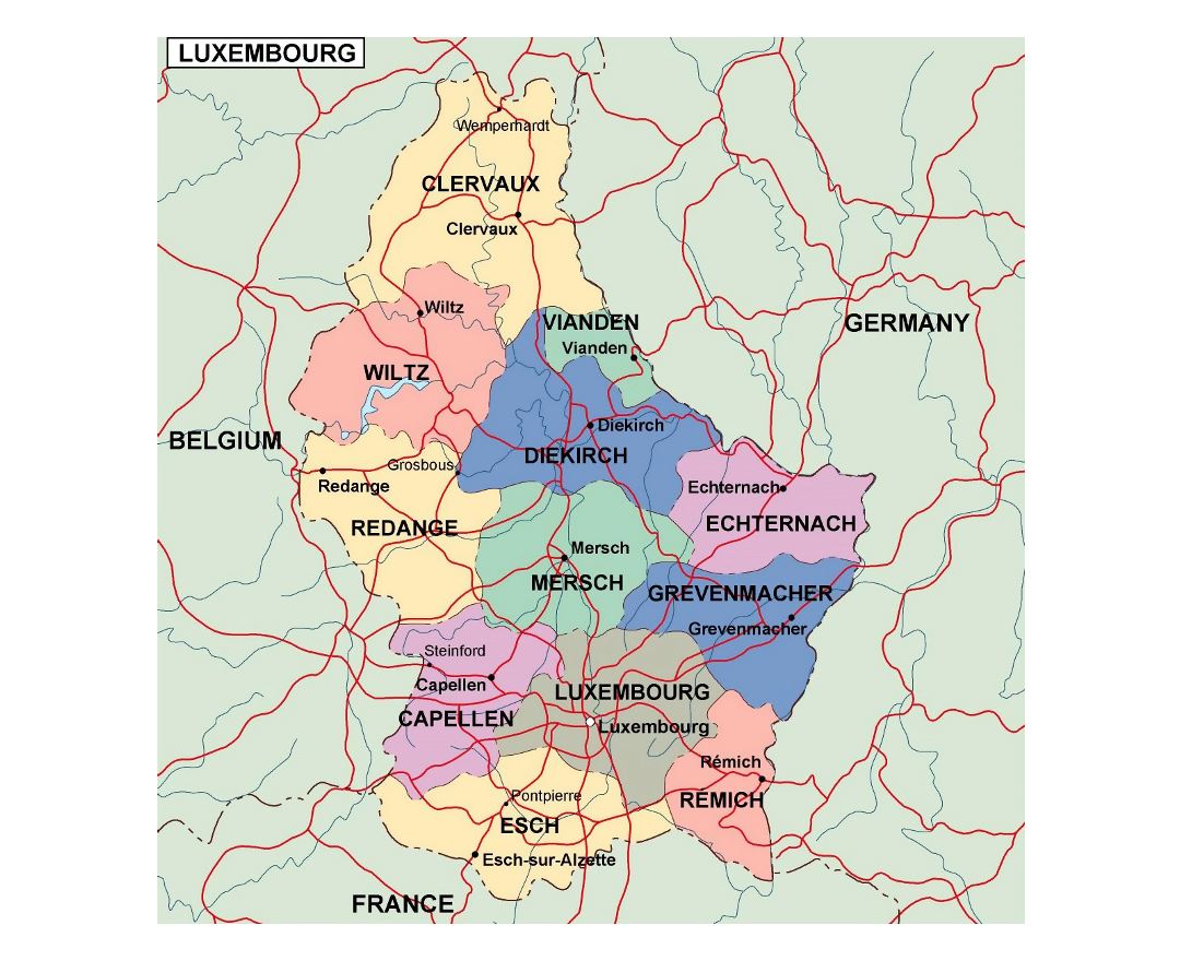
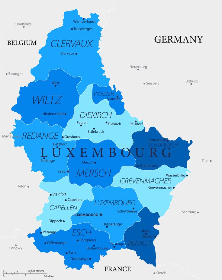
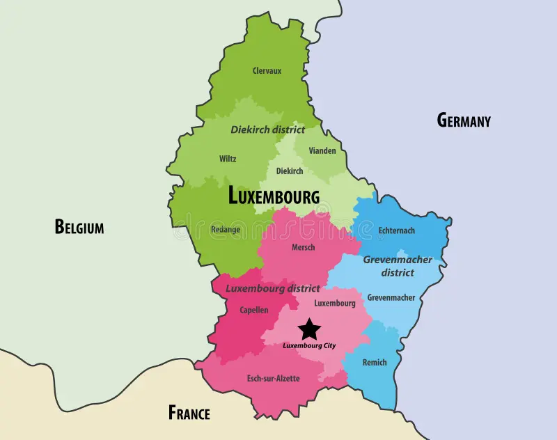
Regions On The Map Of Luxembourg
Luxembourg is divided into multiple administrative regions, each with its own distinct geography and culture. Understanding these regions is crucial when studying the map of Luxembourg.
1. Luxembourg City Region
The capital and surrounding areas, this region includes most of the country’s government institutions, commercial centers, and historical landmarks.
2. Diekirch Region
Located in the north, this region is known for its natural beauty and outdoor activities. The Luxembourg Ardennesare part of this region, with rugged hills and forests perfect for hiking.
3. Grevenmacher Region
Situated in the eastern part of the country, this region is home to the Moselle Riverand several vineyards that produce Luxembourg’s famous wine. It also includes picturesque towns like Remich.
4. Redange Region
A primarily rural area in the west of Luxembourg, Redange is known for its stunning natural landscapes, including nature parksand agricultural zones.
Population Of Luxembourg
As of the latest estimates, Luxembourg has a population of approximately 645,000 people, making it one of the smallest countries in Europe by population. Despite its small size, Luxembourg has a multicultural and diverse society, with a significant percentage of foreign-born residents. This includes individuals from neighboring countries such as Belgium, France, and Germany, contributing to Luxembourg's rich cultural fabric.
Currency Of Luxembourg
The official currency of Luxembourg is the Euro (€), which is used by most European Union (EU) countries. Luxembourg adopted the Euro in 2002, replacing the Luxembourg franc. As a founding member of the EU and the Eurozone, Luxembourg's economy is closely tied to the currency, making it an integral part of the broader European financial landscape.
Dialing Code Of Luxembourg
Luxembourg’s international dialing code is +352. This prefix is used when calling Luxembourg from outside the country. Whether you're calling Luxembourg from Europe, Asia, or the Americas, dialing this code ensures your call is routed correctly.
Luxembourg's telephone infrastructure is highly developed, offering reliable service both domestically and internationally. The country also supports advanced mobile networks, making it easy for residents and visitors to stay connected.
Language Of Luxembourg
Luxembourg has three official languages: Luxembourgish, French, and German. These languages are used in different contexts:
- Luxembourgish(Lëtzebuergesch) is the national language and is spoken daily by the majority of Luxembourg's residents.
- Frenchis used for legislative and administrative purposes, including laws and official documents.
- Germanis the language used in the media and also in some administrative contexts.
In addition to the official languages, many Luxembourgers are fluent in English, making the country particularly welcoming to international visitors and expatriates.
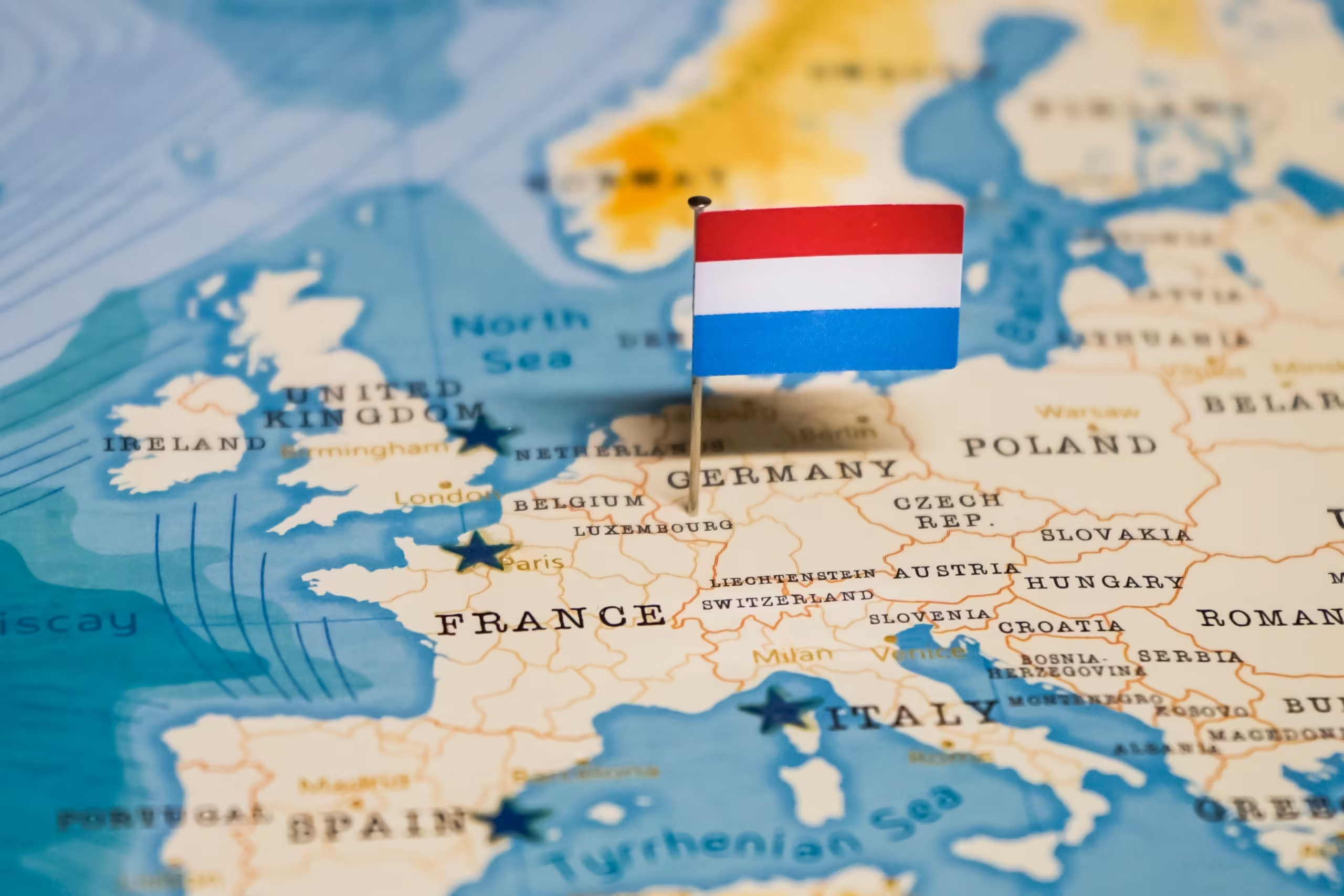
Flag Of Luxembourg
The flag of Luxembourg consists of three horizontal stripes: a red top stripe, a white middle stripe, and a blue bottom stripe. The colors are similar to those of the Netherlands, but the shade of blue in Luxembourg’s flag is lighter. The flag symbolizes Luxembourg’s history, values, and sovereignty.
Luxembourg’s flag is used during national holidays and public events, as well as on government buildings. It is a symbol of the country’s identity and independence in the European and global arenas.
Government Of Luxembourg
Luxembourg operates as a constitutional monarchy with a parliamentary democracy. The Grand Duke is the head of state, and the current Grand Duke, Henri, has been in power since 2000. Luxembourg’s government is a multi-party system, and the Prime Minister is the head of government.
The Grand Duchy’s political system is characterized by the strong influence of the legislative branch, which consists of a unicameral parliament known as the Chamber of Deputies. The country also has a highly efficient and transparent governance system, with an emphasis on human rights, democracy, and social welfare.
Total Area Of Luxembourg
Luxembourg has a total area of 2,586 square kilometers (998 square miles), making it one of the smallest countries in Europe. Despite its small size, Luxembourg is rich in natural beauty, with a diverse range of landscapes, including forests, hills, rivers, and charming towns.
Major Roads And Transportation Routes On The Map
Luxembourg boasts an impressive transportation network, and its strategic location makes it an essential hub for travel within Europe. The country’s roads, highways, and public transportation systems connect Luxembourg with neighboring countries and facilitate easy travel.
A1 Highway
This key highway connects Luxembourg City to the Belgium border and is the main route for travelers heading to the Belgium and France. It’s a vital road for both international and domestic travel.
A6 Highway
The A6 runs from Luxembourg City to the German border. It connects the capital to Trier, Germany, and is an essential route for cross-border travel.
A3 Highway
This highway connects Luxembourg City to the France border and provides access to key French cities, making it an important route for trade and tourism.
Tourism And Travel With A Map Of Luxembourg
When visiting Luxembourg, having a map can greatly enhance the travel experience. The country’s compact size makes it easy to navigate, but a detailed map helps travelers plan their trips efficiently.
- Top attractionssuch as Luxembourg City, Vianden Castle, and Müllerthal are well-signposted, and the map shows how to travel between them using highways or public transportation.
- For outdoor enthusiasts, maps highlighting hiking trails in the Luxembourg Ardennes or Müllerthal are invaluable.
Types Of Luxembourg Map
Luxembourg is represented on various types of maps depending on the purpose of the map:
- Political Map: Shows the boundaries of Luxembourg, neighboring countries, and administrative regions (municipalities).
- Topographic Map: Highlights the natural features such as mountains, forests, rivers, and elevation.
- Climate Map: Indicates the typical weather patterns in Luxembourg, such as temperature ranges and rainfall.
- Road Map: Displays Luxembourg’s road network, including highways, major routes, and inter-country connections.
- Tourism Map: A map tailored for visitors, highlighting major tourist attractions, hiking trails, and landmarks.
- Historical Map: Focuses on the historical evolution of Luxembourg, such as territorial changes over the centuries.
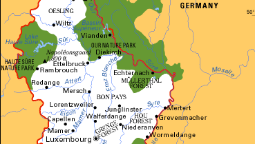
Natural Wonders On The Map Of Luxembourg
1. Müllerthal Region (Little Switzerland)
The Müllerthal Region, often referred to as "Little Switzerland," is one of Luxembourg's most stunning natural wonders. Located in the eastern part of the country, this region is famous for its rugged hills, dense forests, and unique rock formations. The area is crisscrossed with well-maintained hiking trails that allow visitors to explore the breathtaking landscapes of moss-covered rocks, narrow gorges, and cascading waterfalls.
2. Luxembourg Ardennes
The Luxembourg Ardennes is a mountainous region located in the northern part of Luxembourg. Known for its dense forests, steep hills, and picturesque valleys, this area is an outdoor paradise for hiking, cycling, and wildlife spotting. The Luxembourg Ardennes is home to several charming towns and villages, many of which are steeped in history. For those seeking the perfect backdrop for a relaxing and adventurous getaway, the region offers an excellent option for European vacations, combining natural beauty with cultural charm.
3. Vianden Castle
Located in the picturesque town of Vianden, Vianden Castle is one of Luxembourg’s most iconic historical landmarks. Perched high on a hill overlooking the Our River, the castle dates back to the Romanesque period, with parts of it dating back as far as the 11th century. Over the centuries, the castle has undergone extensive restoration, and today, visitors can explore its towers, courtyards, and walls while enjoying panoramic views of the surrounding countryside.
4. Clervaux Castle
Situated in the small town of Clervaux in the Luxembourg Ardennes, Clervaux Castle is another significant historical site. The castle, originally built in the 12th century, is now home to several museums, including the Family of Man photography exhibition, which was curated by the famous photographer Edward Steichen. The exhibition is housed in a dedicated space within the castle and showcases human life through powerful black-and-white images.
5. Bock Casemates (Casemates Du Bock)
The Bock Casemates are a complex of underground tunnels and fortifications located in Luxembourg City, part of the old city's fortifications that have earned it a UNESCO World Heritage status. Originally constructed in the 17th century, these casemates were expanded and strengthened over the centuries to defend the city against invaders. Today, visitors can explore the tunnels, which wind through the cliffs surrounding the city, offering unique perspectives of the cityscape below.
6. The American Cementery Memorial
Located just outside the capital, in Hamm, the American Cementery Memorial is a poignant site dedicated to the memory of over 5,000 American soldiers who lost their lives during World War II. The cemetery is beautifully maintained, with rows of white crosses and Stars of David marking the graves of the soldiers. It also features a memorial that commemorates the Battle of the Bulge and the contributions of the United States during the war.
7. The Moselle River And Vineyards
Running along the eastern border of Luxembourg, the Moselle River is a significant natural feature on the map. It is particularly famous for the wine region that stretches along its banks, where Luxembourg’s Moselle wine is produced. The area is dotted with charming towns such as Remich and Ettelbruck, which are ideal for wine lovers looking to explore vineyards, enjoy wine tastings, and learn about the winemaking process.
8. The Red Rock Region
The Red Rock Region (or Terres Rouges) is located in the southern part of Luxembourg and is known for its unique geological features. The region is rich in iron ore deposits, which historically supported Luxembourg’s thriving steel industry. Today, the Red Rock Region is an area of industrial heritage, with remnants of old steel mills, slag heaps, and mining sites. The region also offers some stunning landscapes, with the rolling hills and natural parks providing a scenic contrast to its industrial past.
9. Guttland Region
The Guttland Region is located in the southern part of Luxembourg and is known for its lush, rolling landscapes, rich forests, and fertile farmlands. This region offers a variety of outdoor activities such as hiking, cycling, and birdwatching. Guttland is also home to several charming towns, including Ettelbruck and Mersch, where visitors can enjoy local culture and cuisine. The region is often referred to as Luxembourg's "Garden," thanks to its picturesque rural landscapes.
10. The Luxembourg City Old Town
The Old Town of Luxembourg City is a UNESCO World Heritage Site that has been meticulously preserved to maintain its historical charm. The map of Luxembourg City highlights the city's medieval streets, with cobblestone alleys, ancient walls, and historical buildings scattered throughout. Key attractions within the Old Town include the Grand Ducal Palace, Place d'Armes, and the Notre-Dame Cathedral.
The Royal Family And The Map Of Luxembourg
The Grand Ducal Palace, located in Luxembourg City, is the residence of the Grand Duke and his family. This royal landmark, clearly marked on the map, represents Luxembourg’s monarchy and its influence on the country’s history.
Visitors can tour the palace and other royal properties that appear on the map, providing a glimpse into the country’s aristocratic legacy. For those looking to combine work and travel, Luxembourg is quickly becoming one of the best destinations for remote work, offering a blend of history, culture, and modern amenities that appeal to digital nomads.
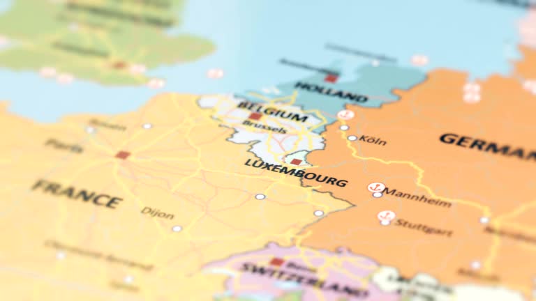
Luxembourg’s Borders And Neighboring Countries
Luxembourg is a landlocked country bordered by three countries:
- Belgiumto the west and north
- Germanyto the east
- Franceto the south
Luxembourg’s location at the heart of Western Europe makes it a key crossroad for international trade and cultural exchange. The country has strong diplomatic and economic ties with its neighbors, particularly within the European Union. The proximity of Luxembourg to these countries influences its culture, language, and economic landscape.
Economy And Luxembourg’s Global Role On The Map
Luxembourg’s strategic location has allowed it to become an economic powerhouse in Europe. The country’s financial sector is one of the largest in the world, and Luxembourg City hosts several international banking institutions. On the map, you’ll notice key economic zones and areas with a high concentration of financial and business hubs.
Climate Map
Luxembourg has a temperate maritime climate, characterized by mild winters and cool summers. The average temperature during the summer months (June-August) ranges from 18°C to 22°C (64°F to 72°F), while winters (December-February) typically have temperatures between 0°C and 5°C (32°F to 41°F).
The climate is influenced by the North Atlantic Drift, which brings moisture from the ocean, resulting in frequent rain throughout the year. The country experiences four distinct seasons, with the spring and autumn months bringing mild and pleasant weather, making Luxembourg ideal for outdoor activities like hiking and cycling.
Interesting Facts About Luxembourg
- Small but Wealthy: Luxembourg is one of the wealthiest countries in the world, with a high GDP per capita.
- Multilingual Society: Luxembourgers speak three official languages, and many are fluent in English.
- UNESCO World Heritage: Luxembourg City’s Old Town is a UNESCO World Heritage Site, with fortifications dating back to Roman times.
- Grand Duchy: Luxembourg is the only remaining Grand Duchy in the world, with a monarch who holds real political power.
- Vibrant Financial Hub: Luxembourg is known as a global financial center, particularly for banking, investment funds, and insurance.
- Rich History: The country has been ruled by various dynasties, with a strategic location that made it a key military and trade hub.
- Luxembourgish Wine: The country produces wine, especially along the Moselle River, with a long history of winemaking.
- Strong Economy: Luxembourg is one of the founding members of the European Union, NATO, and the United Nations.
- Social Welfare System: It has an advanced social welfare system, offering high levels of healthcare and education.
- Environmental Initiatives: Luxembourg is committed to environmental sustainability and is a leader in green energy and sustainable transport initiatives.
- Transportation: Luxembourg was the first country in the world to make all public transportation free of charge (since 2020).
- Tourism: The country is famous for its medieval castles, including the famous Vianden Castle.
- Famous Residents: Jean-Claude Juncker, former President of the European Commission.
- GDP (Nominal): Approximately $70 billion (2023)
FAQs
What Are The Main Regions Of Luxembourg?
Luxembourg is divided into four key regions: Luxembourg City, Diekirch, Grevenmacher, and Redange. Each region has its own unique geography, culture, and landmarks.
What Are The Best Landmarks To Visit In Luxembourg?
Some of Luxembourg's best landmarks include Vianden Castle, the Müllerthal Region (Little Switzerland), and the Grand Ducal Palace in Luxembourg City.
How Can I Travel Around Luxembourg Using A Map?
Luxembourg’s compact size and well-developed transportation system make it easy to travel by car, train, or bus. The country is also famous for its free public transportation, which includes trains, buses, and trams.
Why Is Luxembourg An Important Economic Hub In Europe?
Luxembourg’s strategic location and robust financial sector make it a central economic player in Europe, with many international banks and investment firms headquartered in Luxembourg City.
Can I Hike In Luxembourg?
Yes, Luxembourg offers numerous hiking trails, particularly in the Luxembourg Ardennes and Müllerthal regions. These areas are marked on the map and are perfect for outdoor enthusiasts.
Conclusion
Luxembourg may be a small country, but its historical landmarks, natural wonders, and dynamic economic presence make it a significant player on the European stage. With its multilingual population, thriving financial sector, and stunning landscapes, this Grand Duchy is far from ordinary.
Jump to
Quick Facts About Luxembourg
Geographical Overview Of Luxembourg
The Capital Of Luxembourg
Map Of Luxembourg’s Cities
Regions On The Map Of Luxembourg
Population Of Luxembourg
Currency Of Luxembourg
Dialing Code Of Luxembourg
Language Of Luxembourg
Flag Of Luxembourg
Government Of Luxembourg
Total Area Of Luxembourg
Major Roads And Transportation Routes On The Map
Tourism And Travel With A Map Of Luxembourg
Types Of Luxembourg Map
Natural Wonders On The Map Of Luxembourg
The Royal Family And The Map Of Luxembourg
Luxembourg’s Borders And Neighboring Countries
Economy And Luxembourg’s Global Role On The Map
Climate Map
Interesting Facts About Luxembourg
FAQs
Conclusion

Michael Rachal
Author
Michael Rachal believes that luxury lies in the details. With over 20 years of experience in the luxury travel industry, he has crafted hundreds of bespoke itineraries for clients seeking personalized, unforgettable experiences.
Whether guiding clients through private cultural tours or curating culinary journeys with world-renowned chefs, Michael ensures that each trip is tailored to perfection.
His ability to anticipate needs and exceed expectations has earned him a reputation as a leading expert in luxury travel.

Finn Wilde
Reviewer
For Finn Wilde, the wilderness is more than just a destination - it’s a way of life. Over the past decade, he has led multiple expeditions in some of the world’s most remote regions, from the icy fjords of Greenland to the rugged trails of Patagonia.
Finn emphasizes sustainability in all of his adventures, helping participants connect with nature while promoting responsible exploration. His expeditions inspire individuals to explore the great outdoors while fostering a deep respect for the environment.
Latest Articles
Popular Articles