Map Of Belgium - Cities, Roads, And Top Attractions
Maximize your trip to Belgium with a reliable map that shows the best routes and top tourist destinations across the country.
Author:Michael RachalReviewer:Finn WildeDec 19, 20241.2K Shares139.2K Views
Belgium, a country in Western Europe, is renowned for its rich history, unique cultural heritage, and diverse landscapes. Examining its geographical layout through a map offers valuable insights into its cities, regions, and natural landmarks. This article provides a detailed look at the Map of Belgiumand what it reveals about this fascinating country.
Quick Facts About Belgium
- Capital: Brussels
- Population: Over 11.7 million (2024 estimate)
- Area: 30,689 km² (11,849 sq mi)
- Official Languages: Dutch, French, German
- Currency: Euro (€)
- Time Zone: Central European Time (CET, UTC+1), Central European Summer Time (CEST, UTC+2)
- Government: Federal parliamentary constitutional monarchy
- Borders: Shares borders with France, Germany, Luxembourg, and the Netherlands
- Famous Landmark: Grand Place in Brussels
- Longest River: Meuse River (925 km, shared with France and the Netherlands)
- Highest Point: Signal de Botrange (694 meters)
- UNESCO World Heritage Sites: 13
- National Anthem: "La Brabançonne"
- Famous Foods: Belgian waffles, chocolate, fries, and beer
- Major Industry: Manufacturing, chemicals, and technology
- National Day: July 21 (commemorates the inauguration of King Leopold I in 1831)
- Famous Person: Audrey Hepburn, an actress born in Brussels
- Tourist Attraction: Bruges, known as the "Venice of the North"
- Flag: Three vertical stripes in black, yellow, and red
- Independence Day: October 4 (celebration of independence from the Netherlands in 1830)
Geographical Overview Of Belgium
Belgium is situated in Western Europe, bordered by France to the south and west, Germany to the east, Luxembourg to the southeast, and the Netherlands to the north. Its location makes it a crossroads of European cultures and trade routes.
Belgium covers an area of approximately 30,000 square kilometers, making it one of Europe’s smaller countries. Its geography is characterized by three main regions: the coastal plains in the northwest, the central plateau, and the Ardennes uplands in the southeast. The country has an extensive network of rivers and canals, including the Meuse and Scheldt Rivers, which are vital for transportation and commerce.
Capital Of Belgium
Brussels, the capital of Belgium, is a city that effortlessly blends its rich history with a modern cosmopolitan vibe. Known as the political and cultural heart of Europe, it serves as the de facto headquarters of the European Union (EU)and NATO, making it one of the most influential cities in the world.
Key Attractions In Brussels
- Grand Place: A UNESCO World Heritage Site, the Grand Place is considered one of the most beautiful squares in Europe. Surrounded by stunning guild halls, the Town Hall, and the King’s House (Maison du Roi), it is the centerpiece of the city and hosts cultural events like the biennial Flower Carpet Festival.
- Atomium: Built for the 1958 World Expo, the Atomium is a futuristic structure representing an iron crystal magnified 165 billion times. Visitors can explore its exhibitions and enjoy panoramic views of the city from its top sphere.
- Royal Palace of Brussels: Though not a residential palace, the Royal Palace serves as the administrative residence of the Belgian monarch. Its elegant architecture and surrounding gardens make it a must-visit site.
- Manneken Pis: This small bronze statue of a peeing boy is one of Brussels’ most famous landmarks, often dressed in costumes for special occasions.
- Mont des Arts: A cultural hub, Mont des Arts offers breathtaking views of the cityscape and houses some of Belgium’s finest museums, including the Royal Museums of Fine Arts.
Brussels is also a culinary paradise, renowned for its Belgian waffles, chocolate, beer, and moules-frites (mussels and fries). Its vibrant nightlife and multicultural atmosphere make it a dynamic and lively destination for visitors.
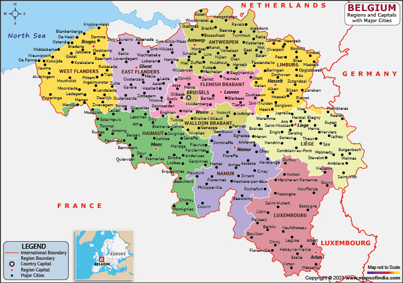
Map Of Belgium Cities
1. Brussels
Brussels, the capital of Belgium, is the country’s largest city and serves as a hub of political, cultural, and economic activity. Known as the "Heart of Europe," Brussels is the headquarters of the European Unionand NATO, giving it immense geopolitical importance.
The city is a fascinating mix of historical landmarks and modern architecture. The Grand Place, a UNESCO World Heritage Site, is one of Europe’s most stunning squares, surrounded by opulent guild halls and the imposing Town Hall.
The Atomium, a futuristic structure built for Expo 58, symbolizes Brussels' innovative spirit and offers panoramic views of the city. Brussels is also a cultural melting pot, with a population representing over 180 nationalities.
Its culinary scene is world-renowned, featuring Belgian waffles, chocolates, and a variety of craft beers, while its comic art legacy is celebrated through murals and the famous Comic Strip Museum.
2. Antwerp
Antwerp, located in the Flemish region of Belgium, is the country’s second-largest city and a global center for the diamond trade. Known as the “Diamond Capital of the World,” Antwerp handles a significant portion of the world's rough and polished diamonds.
The city’s artistic heritage is equally impressive, with the Cathedral of Our Ladyhousing masterpieces by Peter Paul Rubens, who lived and worked in Antwerp. The bustling Antwerp Port, one of Europe’s largest, plays a vital role in international trade and commerce.
The city’s fashion district has earned it a reputation as a style capital, with designers from the Royal Academy of Fine Arts making global waves. Antwerp is also a vibrant city for nightlife, with trendy bars, clubs, and a thriving music scene that attracts visitors from all over.
3. Ghent
Ghent is a dynamic university city that combines a rich medieval past with youthful energy. Its skyline is dominated by the Gravensteen Castle, a medieval fortress that offers insights into the city’s feudal history, and St. Bavo’s Cathedral, home to the world-famous Ghent Altarpieceby the Van Eyck brothers.
The city’s Graslei and Korenlei waterfronts are bustling with cafes, restaurants, and historic buildings, making them popular spots for both locals and tourists.
Ghent is also known for its commitment to sustainability, with extensive cycling paths and a thriving vegetarian food scene. The city hosts numerous festivals, including the annual Gentse Feesten, which transforms its streets into a celebration of music, art, and culture.
4. Bruges
Often referred to as the “Venice of the North,” Bruges is a fairy-tale city renowned for its medieval charm and picturesque canals. The city’s cobblestone streets are lined with Gothic churches, historic buildings, and vibrant markets. The Belfry of Bruges, a medieval bell tower, offers panoramic views of the city and its surroundings. Bruges is also home to the Basilica of the Holy Blood, a Gothic chapel that houses a relic believed to contain the blood of Christ. Known for its lace-making traditions and breweries, Bruges attracts millions of tourists annually, who come to experience its romantic atmosphere and timeless beauty.
5. Liège
Situated along the Meuse River in Wallonia, Liège is Belgium’s fifth-largest city and a cultural and economic hub. The city is known for its innovative architecture, such as the futuristic Liège-Guillemins train stationdesigned by Santiago Calatrava, which serves as a gateway to the city. Historical landmarks like the Montagne de Bueren, a 374-step staircase, provide panoramic views of Liège and its surrounding area. The city’s vibrant nightlife, eclectic culinary offerings, and numerous museums make it a lively destination. Liège is also famous for its Liège waffles, a sweet treat enjoyed by locals and visitors alike.
6. Charleroi
Charleroi, located in the Walloon region, has a rich industrial history that has shaped its identity. Once a coal mining and steel production powerhouse, the city has transformed in recent years, becoming a hub for art and innovation. The BPS22 Museum of Art, housed in a former industrial building, showcases contemporary and experimental works. Charleroi is also known for its vibrant street art scene, with murals and installations adorning its urban landscape. The city’s entrepreneurial spirit is reflected in its growing tech sector, while its historical sites, like the Saint-Christophe Church, provide a glimpse into its past.
7. Namur
Namur, the capital of Wallonia, is a city of strategic and historical importance. Nestled at the confluence of the Meuse and Sambre Rivers, Namur is dominated by its iconic Citadel, a sprawling fortress that offers panoramic views of the city and surrounding countryside. The city’s streets are lined with artisan shops, cafes, and bustling markets, making it a vibrant cultural center. Namur is also a gateway to the Ardennes, a region of natural beauty that attracts outdoor enthusiasts. The city’s blend of history, culture, and modern amenities makes it a must-visit destination in Belgium.
8. Leuven
Leuven, a lively university town, is known for its academic excellence and vibrant atmosphere. Home to KU Leuven, one of Europe’s oldest universities, the city is infused with youthful energy and intellectual curiosity. Leuven’s Gothic Town Hallis an architectural marvel, adorned with intricate sculptures, while the grand St. Peter’s Churchis a testament to the city’s rich religious heritage. The city’s Oude Markt, often referred to as the “longest bar in the world,” is a popular gathering spot, lined with pubs and cafes. Leuven is also the birthplace of Stella Artois beer, adding to its global reputation as a city of brewing excellence.
9. Mons
Mons, located in the Walloon region, is a city of art and history. Its Grand Placeis a charming square surrounded by elegant architecture, while the UNESCO-listed Belfryoffers panoramic views of the city and its surroundings. Mons is renowned for its annual Doudou festival, a folkloric event featuring the reenactment of the battle between St. George and the dragon. The city gained international recognition as the European Capital of Culture in 2015, further cementing its status as a cultural hotspot.
10. Hasselt
Hasselt, the capital of the Limburg province, is a city that combines tradition with modernity. Known for its annual Jenever Festival, celebrating the local juniper-flavored spirit, Hasselt has earned the nickname “Capital of Taste.” The city’s Japanese Garden, the largest in Europe, offers a tranquil escape from urban life. Hasselt is also a shopping destination, with its vibrant city center filled with boutiques and cafes. The city’s cultural scene is enriched by its museums, theaters, and events, making it a lively and welcoming place to visit.
Regions On The Map Of Belgium

Belgium is divided into three main regions, each with its own distinct cultural identity, language, and geographical features. These regions - Flanders, Wallonia, and the Brussels-Capital Region - together showcase the rich diversity and complexity of Belgium as a nation. Understanding these regions offers insight into the country’s social, political, and economic landscape.
Flanders (Northern Belgium)
Flanders, located in the northern part of Belgium, is the Dutch-speaking region of the country. It is known for its flat, fertile landscapes, bustling cities, and thriving economic hubs. The region is home to major cities like Antwerp, Bruges, Ghent, and Leuven, each offering a unique mix of historical charm and modern sophistication. Antwerp, a global diamond and fashion capital, is a vital economic center, while Bruges and Ghent are famous for their well-preserved medieval architecture and cultural heritage.
Flanders is also the country’s economic powerhouse, with industries ranging from manufacturing and logistics to technology and agriculture. The region’s ports, particularly the Port of Antwerp, are among the busiest in Europe, driving international trade. Culturally, Flanders is known for its contributions to art and design, being the birthplace of Flemish masters like Rubens and Van Eyck. The local cuisine is equally notable, with Flemish stew, fries, and regional beers being among the highlights.
Wallonia (Southern Belgium)
Wallonia, the French-speaking region of Belgium, occupies the southern half of the country and is characterized by its rolling hills, dense forests, and picturesque countryside. The Ardennes, a rugged natural area in southeastern Wallonia, is a haven for outdoor enthusiasts, offering hiking, cycling, and wildlife experiences. Wallonia’s major cities include Liège, Namur, Mons, and Charleroi, each with its own cultural and industrial significance.
Liège, located along the Meuse River, is a dynamic cultural hub, while Namur, the capital of Wallonia, is known for its impressive citadel and role as a gateway to the Ardennes. Mons, with its UNESCO-listed Belfry and annual Doudou festival, is a city steeped in history and tradition. Charleroi, once an industrial giant, has reinvented itself as a center for art and innovation. Economically, Wallonia has a strong focus on industry, with sectors like aerospace, technology, and green energy gaining prominence in recent years.
Brussels-Capital Region
The Brussels-Capital Region is a bilingual area (French and Dutch) and serves as the political, cultural, and economic heart of Belgium. Located geographically within Flanders, Brussels is an independent region with immense global significance, being home to the European Union and NATO headquarters. As Belgium’s capital, it is a melting pot of cultures, languages, and traditions, with a population that reflects its international status.
Brussels boasts iconic landmarks such as the Grand Place, Atomium, and the Royal Palace, as well as world-class museums and galleries. Its neighborhoods are a fascinating blend of old and new, with medieval streets in the city center giving way to modern business districts like the European Quarter. The culinary scene in Brussels is diverse and exceptional, ranging from traditional Belgian waffles and chocolates to international cuisines.
The Brussels-Capital Region is also a key driver of Belgium’s economy, with industries like finance, technology, and services playing a significant role. Its cosmopolitan atmosphere and strategic location make it a vibrant and dynamic region.
Language And Cultural Diversity Across Regions
Each region in Belgium reflects the country’s linguistic and cultural diversity. Flanders is predominantly Dutch-speaking, Wallonia is primarily French-speaking (with a small German-speaking community in the east), and Brussels is officially bilingual. This diversity is a defining feature of Belgium, shaping its identity and governance structure, which is decentralized to allow each region to manage its affairs.
Together, Flanders, Wallonia, and Brussels showcase the unique blend of traditions, languages, and landscapes that define Belgium. These regions, while distinct, contribute to the cohesive yet diverse identity of the nation, making Belgium a fascinating and multifaceted country.
Population Of Belgium
Belgium has a population of approximately 11.7 million peopleas of 2024, making it one of the most densely populated countries in Europe. With an average density of around 383 people per square kilometer, the population is heavily concentrated in urban areas such as Brussels, Antwerp, and Ghent. Belgium’s population reflects its cultural diversity, with distinct linguistic communities: Dutch-speaking Flemings in Flanders, French-speaking Walloons in Wallonia, and a small German-speaking community in eastern Wallonia. The Brussels-Capital Region is notably multilingual and multicultural, with a mix of French, Dutch, and other international languages spoken due to its status as the administrative heart of Europe.
Currency Of Belgium
Belgium uses the Euro (€)as its official currency, a standard monetary unit across most European Union member states. The Euro replaced the Belgian Franc in 2002 when Belgium adopted the common European currency. The use of the Euro simplifies trade and travelwithin the Eurozone, making Belgium an integral part of Europe’s economic network. ATMs, banks, and currency exchange services are widely available across the country, and most establishments accept credit and debit cards, ensuring seamless transactions for both residents and tourists.
Dialing Code Of Belgium
The international dialing code for Belgium is +32. To make an international call to Belgium, dial your country’s exit code, followed by +32 and the local area code without the leading zero, then the phone number. Belgium’s efficient telecommunications system ensures strong connectivity across the country, with mobile and landline networks offering extensive coverage. Regional area codes vary: Brussels uses 2, Antwerp uses 3, and Liège uses 4, among others. Mobile numbers typically begin with prefixes like 047, 048, or 049.
Language Of Belgium
Belgium is a linguistically diverse country with three official languages:
- Dutch: Predominantly spoken in Flanders and by about 60% of the population.
- French: French is used in Wallonia by approximately 40% of Belgians, as well as a significant portion of residents in Brussels.
- German: Spoken by a small community in eastern Wallonia, near the German border.
Brussels, being the capital, is officially bilingual (French and Dutch), but English is widely spoken due to its international population and role as a diplomatic hub. Each language community maintains its own cultural and educational systems, contributing to Belgium’s rich and diverse identity.
Flag Of Belgium
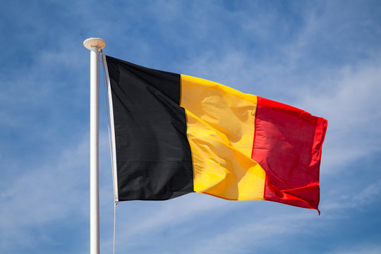
The Belgian flagconsists of three vertical stripes in black, yellow, and red, representing the country’s unity and national pride. The design was inspired by the coat of arms of the Duchy of Brabant, an influential region in Belgian history. Officially adopted in 1831, the flag’s colors and arrangement symbolize Belgium’s struggle for independence and its rich heritage. The flag is prominently displayed during national holidays such as National Dayon July 21, commemorating King Leopold I’s ascension to the throne.
Government Of Belgium
Belgium is a federal parliamentary constitutional monarchy, combining a monarchy with a democratic parliamentary system. The country is divided into three regions: Flanders, Wallonia, and the Brussels-Capital Region, and three linguistic communities: Dutch, French, and German-speaking. The monarch, currently King Philippe, serves as the head of state, while the Prime Minister, leading the federal government, acts as the head of government.
Belgium’s decentralized political structure gives significant autonomy to its regions and communities, allowing them to govern areas such as education, transportation, and economic development. The federal government handles national matters, including defense and foreign policy. Belgium’s complex governance system reflects its diverse cultural and linguistic composition, ensuring representation for all communities.
Total Area Of Belgium
Belgium covers a total area of 30,689 square kilometers (11,849 square miles), making it one of the smallest countries in Europe. Despite its size, Belgium boasts a variety of landscapes, including the flat coastal plains of Flanders, the rolling hills of central Belgium, and the rugged Ardennes forests in Wallonia. Its geographical location in Western Europe, bordering France, Germany, Luxembourg, and the Netherlands, positions Belgium as a strategic crossroads for trade, travel, and cultural exchange.
Types Of Poland Map
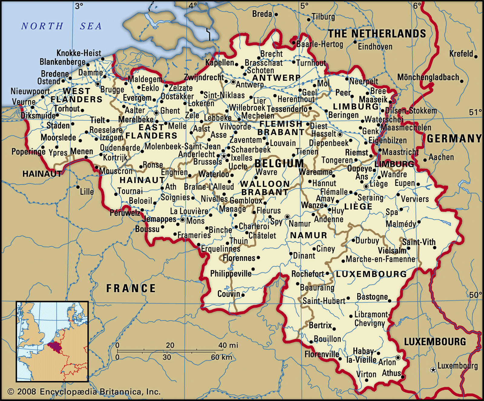
1. Political Map Of Belgium
The political map of Belgium displays the national borders, including its three distinct regions: Flanders, Wallonia, and Brussels-Capital. It also highlights Belgium’s provinces and major cities, such as Brussels, Antwerp, Ghent, and Liège. The map may indicate neighboring countries, including France, Germany, Luxembourg, and The Netherlands, along with their proximity to Belgium.
Purpose: To show Belgium’s political boundaries and administrative divisions, including the three regions and 10 provinces.
2. Administrative Map Of Belgium
This map focuses on Belgium's internal administrative divisions, including the boundaries of the country’s three regionsand 10 provinces. It highlights local governance structures and may show regions with bilingual communities like Brussels, where both Dutchand Frenchare spoken.
Purpose: To illustrate Belgium's internal political structure, including the divisions between the regions, provinces, and municipalities.
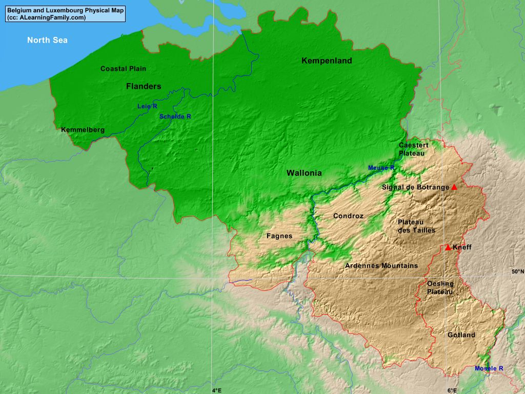
3. Physical Map Of Belgium
The physical map of Belgium shows the country's natural landscape, including the Ardennes Mountainsin the south, the Flemish Lowlandsin the north, and major rivers such as the Meuseand Scheldt. This map highlights the country’s forests, valleys, and national parks, such as Hoge Kempen National Park.
Purpose: To display Belgium's natural features, from mountains and rivers to forests and protected nature zones.
4. Topographic Map Of Belgium
This type of map provides a detailed view of Belgium’s terrain, showing mountain ranges like the Ardennesand Sudetenmountains, as well as the plains and valleys of Flanders. Contour lines illustrate elevation changes, helping to show the relief of the land. It’s especially useful for outdoor activities such as hiking or land-use planning.
Purpose: To provide detailed geographical features, including elevation and topographical variations, useful for outdoor activities.
5. Road Map Of Belgium
A road map of Belgium focuses on the country's major roads and highways, such as the E40, E19, and E411highways, which connect cities like Brussels, Antwerp, and Liège. It also includes rail routes, bus networks, toll areas, rest stops, and fuel stations, making it a helpful resource for travelers.
Purpose: To highlight Belgium’s transport infrastructure, including major highways, rail networks, and travel routes.
6. Tourist Map Of Belgium
The tourist map of Belgium highlights key landmarks, cultural heritage sites, and tourist attractions such as Bruges' medieval city center, the Atomiumin Brussels, and the Grand Place. It also marks important amenities for visitors, including hotels, restaurants, and public transport options.
Purpose: Designed for travelers, this map highlights popular tourist destinations, accommodations, cultural sites, and travel resources.
7. Climate Map Of Belgium
The climate map of Belgium indicates the country's temperate maritime climate, with mild winters and cool summers. It highlights temperature variations across the country, from the coastal areas near the North Seato the more temperate and rainfall-prone Ardennesregion.
Purpose: To illustrate climate patterns, including temperature and precipitation, across Belgium, helping travelers and meteorologists understand regional weather conditions.
8. Economic Map Of Belgium
This map outlines the economic regions of Belgium, highlighting areas of industrial production, natural resources, and economic hubs. It indicates the significance of the Port of Antwerp, the Flemish diamond industry, and the coal miningregion in Wallonia.
Purpose: To illustrate Belgium’s economic landscape, including key industries, resources, and commercial zones.
9. Historical Map Of Belgium
A historical map of Belgium shows the changing political boundaries over time, including the territories of the Holy Roman Empire, the Austrian Netherlands, and the Kingdom of Belgiumpost-independence. It may also highlight historical landmarks such as Waterloo.
Purpose: To illustrate Belgium’s political and territorial changes, especially key moments in its history, such as independence and wars.
10. Cultural Map Of Belgium
A cultural map of Belgium emphasizes the country’s diverse cultural regions, including Flanders, Wallonia, and Brussels. It highlights distinct cultural landmarks, folk traditions, festivals, and notable architecture, like the Belfry of Brugesor the Walloon castles.
Purpose: To focus on Belgium's rich cultural heritage, including festivals, art, architecture, and traditions across its regions.
11. Religious Map Of Belgium
This map depicts the religious landscape of Belgium, where Roman Catholicismpredominates, but it also shows regions with significant Protestant, Orthodox, or Jewish communities. Major pilgrimage sites such as Basilica of the Holy Bloodand Notre-Dame de la Chapelleare also indicated.
Purpose: To highlight the distribution of religious affiliations and important religious landmarks in Belgium.
12. Language Map Of Belgium
The language map of Belgium illustrates the country's linguistic diversity, with Dutchspoken in Flanders, Frenchin Wallonia and Brussels, and Germanin a small eastern region. It may also show bilingual areas like Brussels, where both Dutchand Frenchare official.
Purpose: To display the distribution of languages spoken in Belgium, including regional variations and minority languages.
13. Biodiversity Map Of Belgium
This map shows the biodiversity of Belgium, including national parks like Hoge Kempen, and nature reserves that protect endangered species and diverse ecosystems. It also highlights key biodiversity hotspots, such as the Ardennesregion, which is home to various species of flora and fauna.
Purpose: To focus on the country’s biodiversity, including protected areas and ecosystems that foster wildlife conservation.
Belgium’s Borders And Neighboring Countries
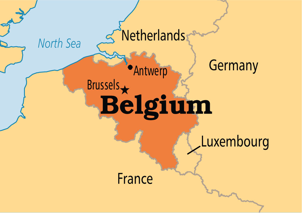
Belgium is centrally located in Western Europe and shares its borders with four countries: France, Germany, Luxembourg, and The Netherlands. These neighboring countries play a significant role in Belgium’s culture, economy, and political ties.
1. France: To the south of Belgium lies France, with which Belgium shares a long cultural and historical connection. The border with France runs through the Nord-Pas-de-Calaisregion and is important for both trade and tourism. The proximity to France has influenced Belgian cuisine, fashion, and even language, with regions like Walloniapredominantly speaking French.
2. Germany: To the east, Belgium shares a border with Germany, primarily marked by the Eifelmountain range and the Vennbahnrailway. This border has historical significance, especially given the tumultuous 20th century when Belgium was involved in both World Wars. Today, Germany and Belgium have strong economic ties, particularly in manufacturing, technology, and logistics.
3. Luxembourg: To the southeast, Luxembourgshares a smaller border with Belgium, particularly in the Ardennesregion. This border is crucial for both the transport of goods and for fostering close diplomatic relations within the European Union, of which both Belgium and Luxembourg are founding members. Luxembourg’s economic activities, such as finance and banking, are also linked to Belgium.
4. The Netherlands: To the north, Belgium shares a long border with the Netherlands, extending from the North Seain the west to the German borderin the east. This northern neighbor plays an important role in Belgium's trade, tourism, and cultural exchanges. The Dutch-speaking Flandersregion of Belgium has many cultural and historical similarities with the Netherlands, and they maintain strong economic relations, especially in sectors like agriculture, technology, and logistics.
National Parks And Landscapes
Belgium offers an impressive array of national parks and protected natural landscapes, each showcasing the country’s rich ecological diversity and offering excellent opportunities for outdoor activities.
1. Hoge Kempen National Parkis Belgium’s only official national park, located in the Limburgregion. It features a remarkable mix of heathlands, pine forests, and wetlands, making it a haven for wildlife. Visitors can explore over 5,700 hectares of natural beauty, with dedicated trails for hiking and cycling. The park is home to a variety of species, including deer, wild boar, and a wide range of birdlife, including several rare species.
2. Ardennes Forest, located in the Walloniaregion, is one of Belgium’s most significant natural areas. This vast expanse of rolling hills, deep valleys, and dense woodlands is perfect for a range of outdoor activities. The Ardennes is particularly popular with hikers, cyclists, and those looking to escape to nature for a peaceful retreat. Its landscape is dotted with picturesque villages and castles, and it’s also home to abundant wildlife, including deer, boar, and numerous bird species. The region is well-known for its rugged terrain, making it a top destination for adventure seekers.
3. Zwin Nature Park, situated along the Belgian-Dutch border, is an important coastal reserve known for its birdwatching opportunities. It serves as a sanctuary for migrating birds and is home to various species, including avocets and spoonbills. The park’s salt marshes and tidal flats offer a unique landscape that is both tranquil and teeming with life. It is one of Belgium’s most important natural areas for ornithological research and a favorite destination for nature enthusiasts.
These national parks and nature reserves are part of Belgium’s ongoing commitment to preserving its diverse ecosystems and offering visitors opportunities to enjoy outdoor pursuits in scenic surroundings. Together, they form a network of protected areas that highlight the country’s dedication to sustainability and biodiversity conservation.
Belgium’s Natural Wonders On The Map
Belgium’s natural wonders, marked by stunning landscapes and unique geographical features, are scattered across the country, each offering something different for nature lovers and outdoor adventurers.
1. The Ardennes regionis perhaps Belgium's most famous natural wonder. Known for its rugged hills, dense forests, and quaint villages, the Ardennes is an outdoor enthusiast's paradise. If it's hiking the Semois River valley, kayaking down the Ourthe River, or exploring the caves and cliffs, this region offers a wide range of activities set amidst breathtaking natural beauty. It is also home to Signal de Botrange, the highest point in Belgium, standing at 694 meters (2,277 feet). From this summit, you can enjoy panoramic views of the surrounding forested hills.
2. The Meuse Riveris another key natural feature that flows through Belgium, offering a picturesque and tranquil setting. Originating in France, it enters Belgium near the town of Dinant, where its steep cliffs and historic citadel create one of the most scenic spots along its path. The river then meanders through the southern part of Belgium, with opportunities for boat tours and cycling along its banks, making it a popular route for tourists exploring the country’s natural landscape.
3. The Caves of Han-sur-Lesse, located in the Ardennes, are another natural wonder of Belgium. These stunning limestone caves have been formed over millions of years and are famous for their underground beauty. Visitors can take guided tours to explore the caves and marvel at their massive stalactites, stalagmites, and unique rock formations. The surrounding Han-sur-Lesse Nature Reserveoffers walking trails that allow visitors to experience the beauty of the region above ground as well.
Together, these natural landmarks and geological features represent the diverse landscapes that define Belgium’s ecological and geographical identity. From rugged mountains and rivers to underground caves and wildlife-rich forests, Belgium’s natural wonders offer something for every kind of explorer.
Major Roads And Transportation
Belgium boasts an extensive and well-connected transportation infrastructure that makes travel easy both within the country and to neighboring countries. With its central location in Europe, Belgium is a key transport hub, particularly for international trade and tourism.
1. The E40is the longest highway in Belgium, stretching from the French border in the west to the German border in the east. It passes through several major cities, including Brussels, Liège, and Ghent, making it one of the country’s busiest roads. The E40 serves as an essential route for both domestic and international travel, linking Belgium with France and Germany.
2. The E411is another important highway that connects Brusselsto Luxembourg, facilitating cross-border travel and commerce. It is a key route for business travelers and commuters, as it connects Belgium with one of its most important economic partners in the European Union.
3. The R1, which serves as a ring road around Antwerp, is a vital traffic artery designed to reduce congestion in the city. Antwerp, as one of the busiest ports in Europe, relies heavily on the R1 to ensure smooth transportation of goods throughout the region.
Belgium is also known for its excellent public transport network, which includes trains, trams, and buses. The SNCB/NMBS, Belgium's national railway company, operates an extensive train network connecting major cities like Brussels, Liège, Antwerp, and Ghent, as well as international routes to neighboring countries like France, Germany, and the Netherlands. The Brussels Metroand tram networksare also efficient for getting around the capital, providing convenient and affordable transportation for both locals and visitors.
Climate Map
Belgium experiences a temperate maritime climate, influenced by the surrounding North Seaand the Atlantic Ocean. This results in relatively mild winters and cool summers, with moderate rainfall throughout the year. The climate mapof Belgium would highlight distinct regional variations, which are influenced by the country’s geography.
In winter, temperatures in Belgium rarely fall below freezing, especially in the lowlands. However, the Ardennesregion, being at higher elevations, often experiences colder temperatures and occasional snowfall, making it a popular destination for winter sports such as skiing and snowboarding. The coastal areasof Belgium, influenced by the North Sea, tend to experience milder winters but receive more rainfall than other parts of the country.
During summer, Belgium enjoys moderate temperatures, averaging around 20°C (68°F). Heatwaves are uncommon but do occasionally push temperatures above 30°C (86°F), especially in the more urban areas. The coastal regions tend to remain cooler due to the moderating effect of the North Sea. Overall, Belgium's climate is characterized by its moderate temperatures and the steady rainfall that helps sustain the country’s lush green landscapes.
Belgium’s Economy
Belgium’s economy is highly developed and diverse, driven by a mix of industrial production, technological advancements, and a robust logistics sector.
Manufacturingis a key pillar of the Belgian economy, particularly in the automobile, chemicals, machinery, and diamondindustries. Belgium is one of the leading countries in the diamond trade, with Antwerpbeing one of the world’s primary centers for diamond cutting and trading. The Port of Antwerpserves as one of Europe’s largest and busiest ports, facilitating the import and export of goods, raw materials, and machinery.
In the realm of technology, Belgium is a growing center for biotechnology, pharmaceuticals, and information technology. With a highly educated workforce and strong research institutions, Belgium has become home to numerous startups and multinational tech companies, especially in the Walloonand Flandersregions.
Logisticsplays a major role in Belgium’s economy due to its strategic position in Europe. The country’s advanced transportation infrastructure - consisting of road networks, railways, and ports - enables it to act as a key logistics hub, making it an important center for both domestic and international trade.
Belgium’s economy is closely linked to the European Union, and the country plays a significant role in EU governance and trade agreements. It serves as a gateway for goods traveling through Europe, with its efficient transport systems linking Belgium to the rest of the continent and beyond.
How To Use A Map Of Belgium For Travel
In Belgium’s cities, a map helps you navigate through the bustling streets of Brussels, Antwerp, Ghent, and Bruges, ensuring that you reach popular landmarks like the Atomium, Grand Place, or Belfry of Brugeswithout missing a beat. Maps are also helpful for planning public transport routes, with tram, bus, and train options readily available for easy travel.
For nature enthusiasts, a map of Belgium highlighting the country’s national parksand natural reservesis invaluable. Areas like the Ardennesand Hoge Kempen National Parkare perfect for hiking and exploring, and a good map can help you find the best trails and viewpoints.
10 Interesting Facts About Belgium
- Three Official Languages: Belgium has three official languages: Dutch (Flemish), French, and German. The country is divided into linguistic regions, with Dutch spoken in the Flanders region, French in Wallonia, and German in a small area near the German border.
- Home of the European Union: Brussels, the capital of Belgium, serves as the de facto capital of the European Union (EU). Many EU institutions, such as the European Commission and the European Parliament, are headquartered there.
- World-Famous Chocolates: Belgium is renowned for its high-quality chocolates. The country produces over 172,000 tons of chocolate each year, and famous brands like Godiva, Léonidas, and Neuhaus originate here.
- Inventors of French Fries: Despite the name, French fries (or "frites" in French) are believed to have originated in Belgium, not France. They are often served with a variety of sauces, including mayonnaise, which is a Belgian specialty.
- Belgian Beer Culture: Belgium is famous for its unique beer culture, with over 1,500 different types of beer brewed in the country. Belgian beers are often distinguished by their complex flavors, ranging from fruity to spicy.
- Medieval Cities and Architecture: Belgium is home to some of Europe’s most stunning medieval cities, such as Bruges and Ghent. Bruges, in particular, is known for its well-preserved medieval architecture and canals, earning it the nickname "Venice of the North."
- Comic Book Capital: Belgium is the birthplace of some famous comic book characters, such as Tintin, created by Hergé. The country is also home to the Belgian Comic Strip Center in Brussels, celebrating the art form's legacy.
- Castle Country: Belgium is dotted with over 300 castles, ranging from medieval fortresses to grand châteaux. Popular ones include the Château de Bouillon and the Gravensteen Castle in Ghent.
- A Land of Festivals: Belgium hosts numerous festivals throughout the year, including the Tomorrowland Music Festival, one of the world’s largest electronic dance music festivals, and the Carnival of Binche, a UNESCO-recognized cultural heritage event.
- The Atomium: Located in Brussels, the Atomium is a striking building built for the 1958 World Expo. Shaped like an iron crystal magnified 165 billion times, it is one of the most iconic landmarks in Belgium.
FAQs
What Are The Main Languages Spoken In Belgium?
Belgium has three official languages: Dutch (Flemish), French, and German. The language spoken depends on the region you are in.
What Is Belgium Famous For?
Belgium is famous for its chocolates, beer, fries, medieval cities, comics (like Tintin), and cultural festivals.
Is Belgium A Good Travel Destination?
Yes, Belgium is a great travel destination with its rich history, beautiful cities like Bruges and Brussels, and world-renowned food and drinks.
What Is The Capital Of Belgium?
Brussels is the capital of Belgium and also the de facto capital of the European Union.
What Is The Best Time To Visit Belgium?
The best time to visit Belgium is during spring (April to June) and fall (September to October), when the weather is mild and there are fewer tourists.
Conclusion
Belgium is a small but incredibly diverse country, with a rich cultural history and a reputation for delicious food, beer, and chocolates. From its medieval cities to its modern-day EU capital, there's something for every traveler. If you're interested in exploring Belgian art, and history, or simply indulging in local treats, Belgium offers a wealth of experiences that are sure to leave lasting
Jump to
Quick Facts About Belgium
Geographical Overview Of Belgium
Capital Of Belgium
Map Of Belgium Cities
Regions On The Map Of Belgium
Population Of Belgium
Currency Of Belgium
Dialing Code Of Belgium
Language Of Belgium
Flag Of Belgium
Government Of Belgium
Total Area Of Belgium
Types Of Poland Map
Belgium’s Borders And Neighboring Countries
National Parks And Landscapes
Belgium’s Natural Wonders On The Map
Major Roads And Transportation
Climate Map
Belgium’s Economy
How To Use A Map Of Belgium For Travel
10 Interesting Facts About Belgium
FAQs
Conclusion

Michael Rachal
Author
Michael Rachal believes that luxury lies in the details. With over 20 years of experience in the luxury travel industry, he has crafted hundreds of bespoke itineraries for clients seeking personalized, unforgettable experiences.
Whether guiding clients through private cultural tours or curating culinary journeys with world-renowned chefs, Michael ensures that each trip is tailored to perfection.
His ability to anticipate needs and exceed expectations has earned him a reputation as a leading expert in luxury travel.

Finn Wilde
Reviewer
For Finn Wilde, the wilderness is more than just a destination - it’s a way of life. Over the past decade, he has led multiple expeditions in some of the world’s most remote regions, from the icy fjords of Greenland to the rugged trails of Patagonia.
Finn emphasizes sustainability in all of his adventures, helping participants connect with nature while promoting responsible exploration. His expeditions inspire individuals to explore the great outdoors while fostering a deep respect for the environment.
Latest Articles
Popular Articles