Vietnam Map Guide | Geography, Regions, Cities, & Fun Facts
Vietnam, shaped like a graceful 'S' on the map, offers a diverse landscape that captivates travelers. From the bustling cities to the serene countryside, exploring the Vietnam map is the first step to understanding this incredible country.
Author:Finn WildeReviewer:Michael RachalFeb 22, 202642.8K Shares953K Views
Vietnamis a land of breathtaking landscapes, vibrant culture, and a history that dates back thousands of years. Its geography is as fascinating as its people, with an S-shaped coastline stretching over 3,000 kilometers and regions that vary from the lush Mekong Delta to the rugged mountains of the north.
Understanding Vietnam’s map isn’t just about locating cities and borders-it’s a gateway to exploring its rich tapestry of natural wonders, cultural heritage, and economic hubs.
Quick Facts About Vietnam
| Attribute | Details |
| Official Name | Socialist Republic of Vietnam |
| Capital | Hanoi |
| Population | ~99 million (2025 estimate) |
| Total Area | 331,212 km² |
| Major Cities | Ho Chi Minh City, Hanoi, Da Nang |
| Official Language | Vietnamese |
| Currency | Vietnamese Dong (VND) |
| Dialing Code | +84 |
| Time Zone | GMT+7 |
| Geography | S-shaped coastline, diverse terrain (mountains, deltas, coast) |
| Climate | Tropical monsoon climate |
The "S" Shape Of Vietnam: A Geographical Overview
The S-Shaped Coastline
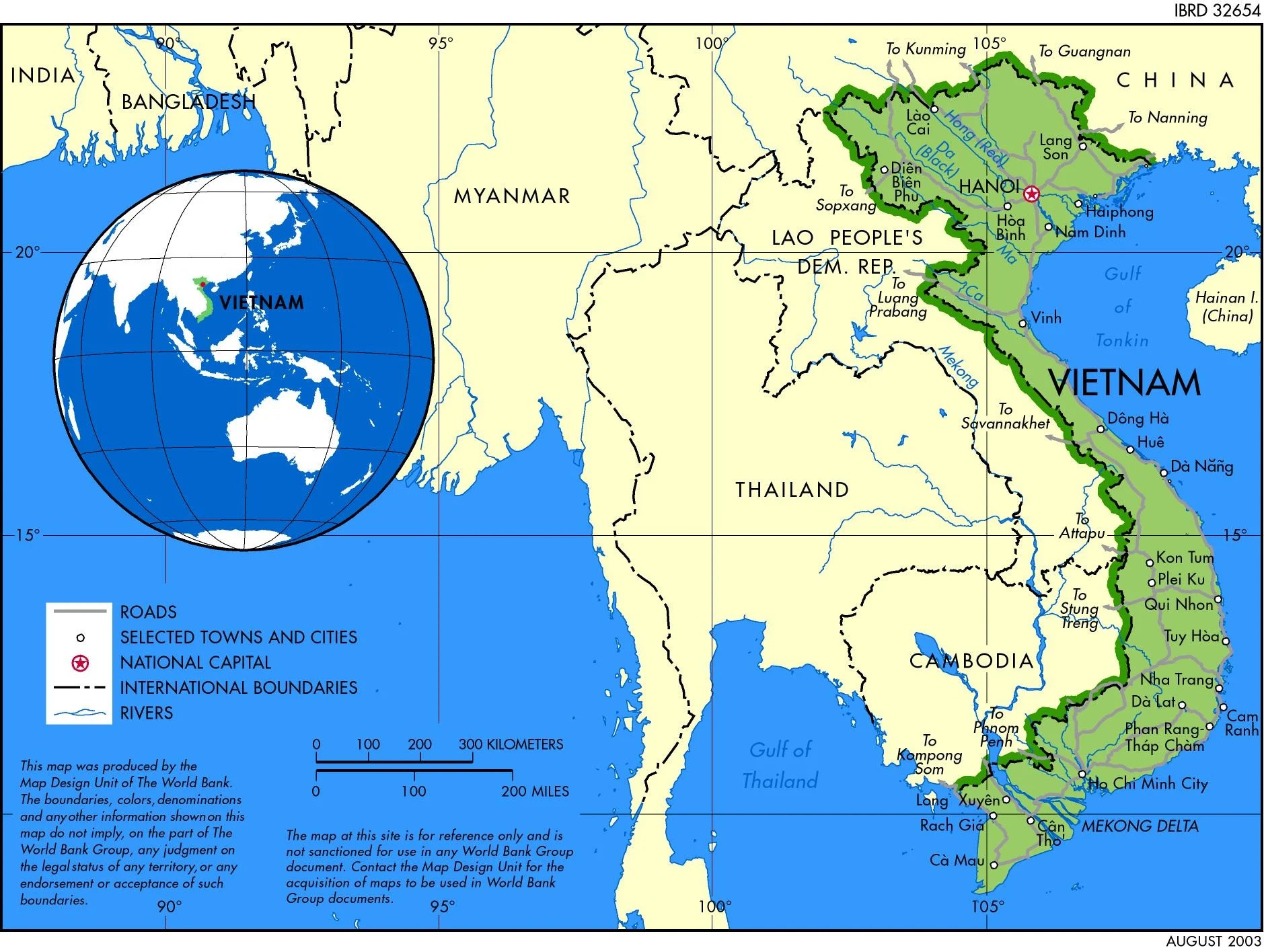
Vietnam’s distinctive S-shaped contour is not just a visual hallmark-it’s a feature that has deeply influenced its history and economy. Stretching along the South China Sea, the coastline has been a vital route for maritime trade and cultural exchange for centuries.
The northern region boasts the Red River Delta, while the central coast is known for its picturesque beachesand bays, and the southern end features the sprawling Mekong Delta.
Mountainous Backbone
The Annamite Cordillera runs parallel to the coast, forming a natural backbone that shapes Vietnam’s geography. These rugged mountains provide a striking contrast to the flat deltas, influencing both the climate and the distribution of settlements.
Peaks like Fansipan, the highest in Indochina at 3,147 meters, are popular among trekkers and adventurers.
Major Rivers And Deltas
Two major river systems define Vietnam’s agricultural heartland. The Red River Delta in the north supports the capital city of Hanoi, while the Mekong Delta in the south is a labyrinth of waterways crucial for rice production and aquaculture. These deltas have been the cradle of Vietnamese civilization, sustaining life for centuries.
Overview Of Vietnam’s Geography
Geographical Location
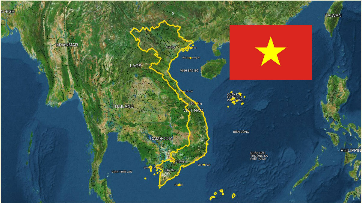
Vietnam is located on the eastern edge of mainland Southeast Asia, bordered by China to the north, Laos and Cambodia to the west, and the South China Sea to the east. Its strategic location has made it a historical crossroads for trade and cultural exchange.
Key Landforms
The country’s topography is a mix of mountains, deltas, coastal plains, and highlands. The northern region is dominated by mountains and the Red River Delta, while the central area features narrow coastal plains flanked by the Truong Son mountains. The south is defined by the vast and fertile Mekong Delta.
Climate And Regions
Vietnam’s climate varies significantly across its three main regions:
- North:Subtropical with four distinct seasons.
- Central:Tropical monsoon climate with significant rainfall.
- South:Tropical, characterized by wet and dry seasons.
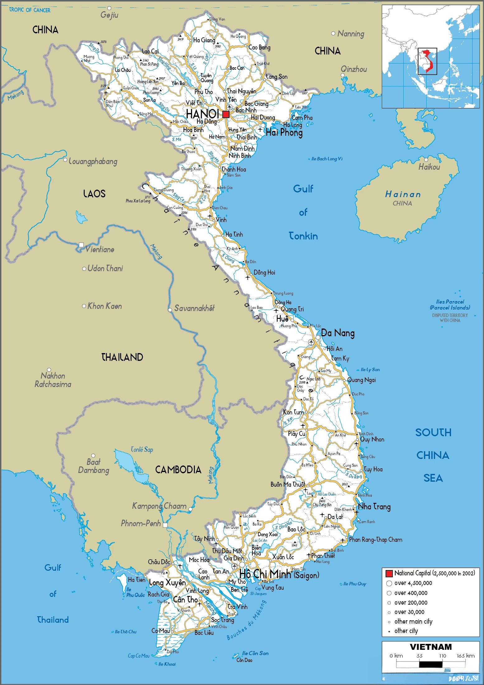
Map Of Vietnam With Cities
Major Cities
Hanoi: The capital city, known for its historic Old Quarter, French colonial architecture, and cultural landmarks. It serves as the political and cultural heart of Vietnam, blending tradition with modernity. Highlights include Hoan Kiem Lake, the Temple of Literature, and the Presidential Palace.
Ho Chi Minh City: Vietnam’s largest city and economic hub, featuring skyscrapers, vibrant markets, and a bustling urban vibe. Its attractions include the Cu Chi Tunnels, Ben Thanh Market, and Notre-Dame Cathedral Basilica. The city is also a gateway to the Mekong Delta.
Da Nang: A coastal city famous for its beaches, culinary delights, and proximity to UNESCO sites like Hoi An and the My Son Sanctuary. The Dragon Bridge and Marble Mountains are must-see attractions. Da Nang also serves as a center for modern infrastructure and tourism.
Hue: Known for its imperial history, Hue offers a glimpse into Vietnam’s royal past with its citadel, ancient tombs, and the Perfume River. The city is a cultural treasure trove, showcasing the Nguyen Dynasty's legacy.
Haiphong: A major port city in northern Vietnam, serving as a gateway to Cat Ba Island and Halong Bay. Haiphong is known for its colonial architecture, lively markets, and industrial significance.
Can Tho: The largest city in the Mekong Delta, known for its floating markets, rice paper villages, and vibrant waterways. Cai Rang Floating Market is a key highlight, offering an authentic glimpse into delta life.
Nha Trang: A coastal resort city renowned for its beaches, diving spots, and Vinpearl amusement park. The city also boasts attractions like Po Nagar Cham Towers and a vibrant nightlife scene.
Vinh: A growing economic and cultural hub in central Vietnam, often overlooked but rich in local charm. It serves as a starting point for exploring the Pu Mat National Park and nearby beaches.
Da Lat: Nestled in the Central Highlands, Da Lat is famous for its cool climate, French-inspired architecture, and stunning natural scenery. Known as the "City of Eternal Spring," it’s a favorite destination for honeymooners.
Hai Duong: A city with a blend of industrial growth and traditional crafts, famous for its green bean cakes and historical relics.
Regional Variations Across The Map
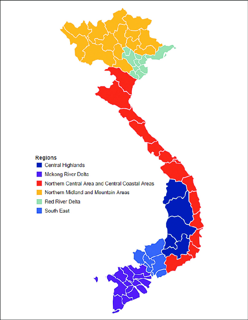
Vietnam, despite its relatively small size, exhibits remarkable geographical diversity, leading to distinct regional characteristics.
North Vietnam:
The northern region is dominated by the Red River Delta, a fertile alluvial plain formed by the Red River and its tributaries. This fertile land has been the cradle of Vietnamese civilization for centuries, supporting a thriving agricultural society.
Rice cultivation is the backbone of the delta's economy, with lush green paddy fields stretching as far as the eye can see.
Beyond the delta, the north is characterized by rugged mountainous terrain. The Hoang Lien Sonmountain range, home to Fansipan, the highest peak in Indochina, presents a dramatic landscape.
These mountainous regions are inhabited by diverse ethnic minority groups, each with unique cultural traditions, languages, and livelihoods. The terraced rice fields meticulously carved into the mountain slopes are a testament to the ingenuity and resilience of these communities.
Central Vietnam:
The central region offers a diverse landscape, ranging from coastal plains to rugged mountains. The Truong Son Mountains, also known as the Annamite Cordillera, form a formidable barrier running through the region.
These mountains significantly influence the climate, creating a more diverse range of weather patterns compared to the north and south. They also played a crucial role in shaping the history and culture of the region, contributing to the development of distinct regional identities.
The central coast boasts stunning beaches, attracting tourists with their white sands and crystal-clear waters. Cities like Da Nanghave emerged as popular beach resorts, while historical sites like Hoi An, a UNESCO World Heritage Site, showcase the region's rich past.
Hoi An, once a thriving trading port, retains its well-preserved ancient architecture, including traditional houses and temples.
South Vietnam:
The southern region is dominated by the Mekong Delta, a vast and intricate network of rivers, canals, and waterways. This fertile delta is one of the most productive agricultural regions in Southeast Asia, renowned for its rice production, fruit orchards, and aquaculture.
The Mekong River and its tributaries provide a vital transportation network, with bustling floating markets where local farmers and traders conduct their business.
Ho Chi Minh City, formerly known as Saigon, is the largest city in the south and a major economic and cultural hub. A dynamic metropolis, it blends modern skyscrapers with colonial architecture, creating a unique urban landscape.
The city's history, particularly its role during the Vietnam War, is reflected in landmarks like the War Remnants Museum and the Cu Chi Tunnels, a network of underground passages used by the Viet Cong.
Types Of Vietnam Maps
Political Map
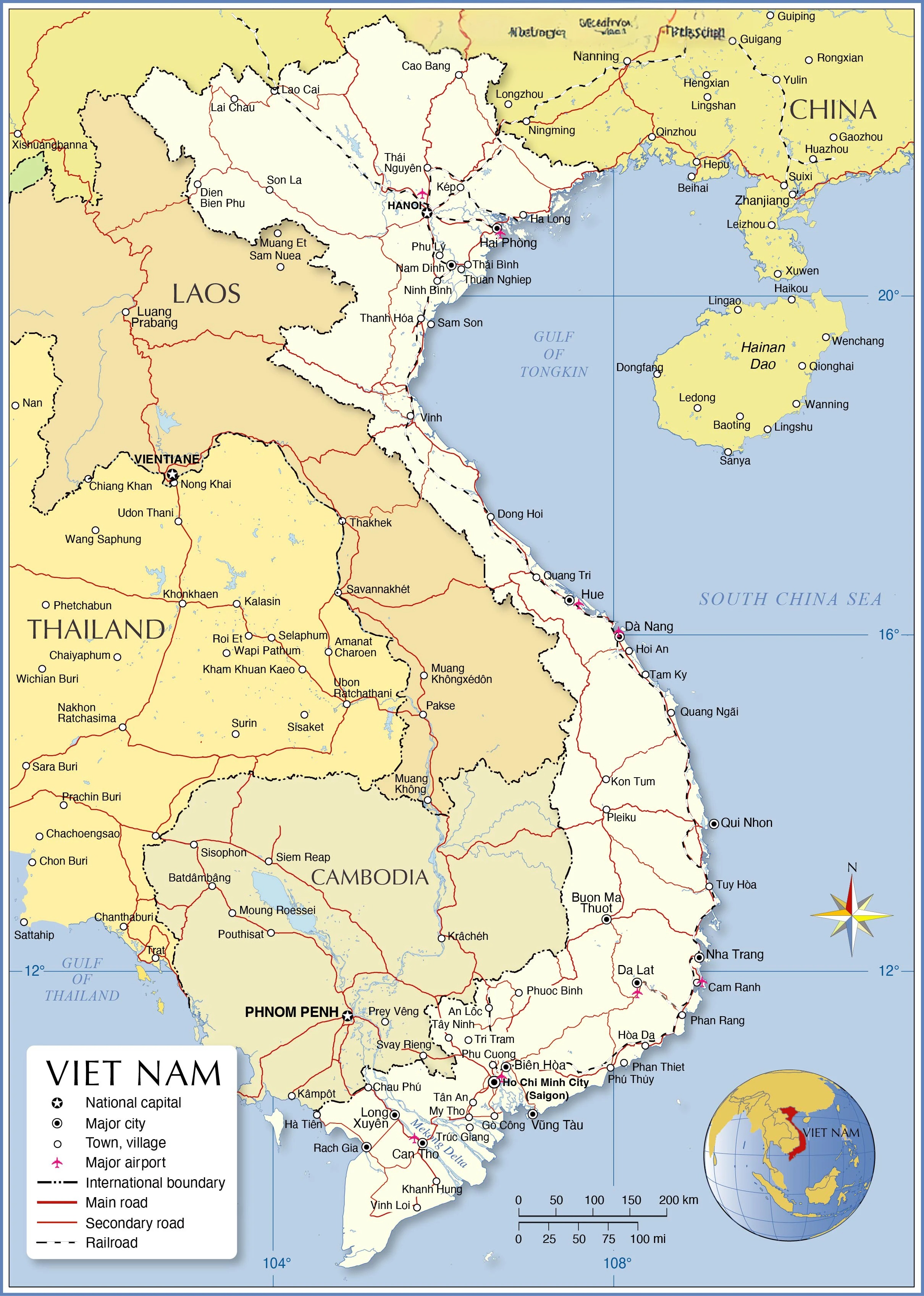
A political map of Vietnam is crucial for understanding the administrative organization of the country. It displays the boundaries of provinces, districts, major cities, and towns, as well as important features such as capitals and administrative divisions.
Vietnam is divided into 58 provincesand 5 centrally governed cities: Hanoi, Ho Chi Minh City, Da Nang, Can Tho, and Haiphong. Political maps not only highlight regional borders but also provide context on the distribution of the population and economic hubs.
They are indispensable tools for governance, urban planning, logistics, and legal matters, helping citizens, businesses, and government entities navigate the country's complex political landscape.
Physical Map
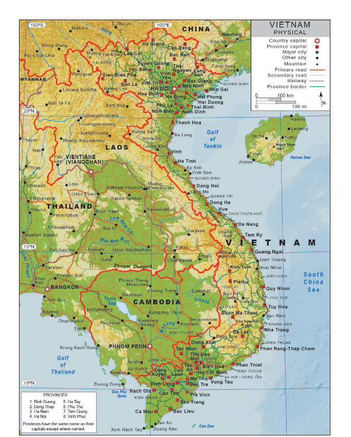
Physical maps of Vietnam reveal the country's diverse and dramatic natural landscape. These maps show topographic features such as mountains, rivers, plateaus, and deltas.
The Annamite Range (Truong Son Mountains) stretches across central and western Vietnam, forming the country’s physical backbone, while the Red River Delta in the north and the Mekong Delta in the south serve as vital agricultural regions.
Elevation gradients and color-coded terrain highlight the varying altitudes, from the towering heights of Fansipan Peak (the highest point in Vietnam) to the low-lying coastal plains.
Physical maps also help identify ecosystems, conservation areas, and natural resources, providing valuable data for environmental studies, agriculture, and disaster management.
Climate Map
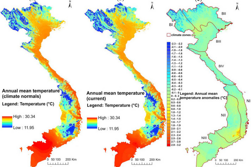
Climate maps are essential for understanding the varied weather patterns that affect Vietnam's regions. These maps show temperature ranges, seasonal rainfall, humidity, and monsoon patterns, which are crucial for agriculture, urban planning, and disaster preparedness.
For instance, the northern regions experience a temperate climate with four distinct seasons, while the southern region has a tropical climate with a distinct wet and dry season.
These maps also identify areas prone to extreme weather, such as floods, droughts, and typhoons, helping local governments and businesses prepare for climate-related challenges.
For travelers, climate maps provide information on the best times to visit each region, guiding decisions on outdoor activities and packing requirements.
Tourism Map
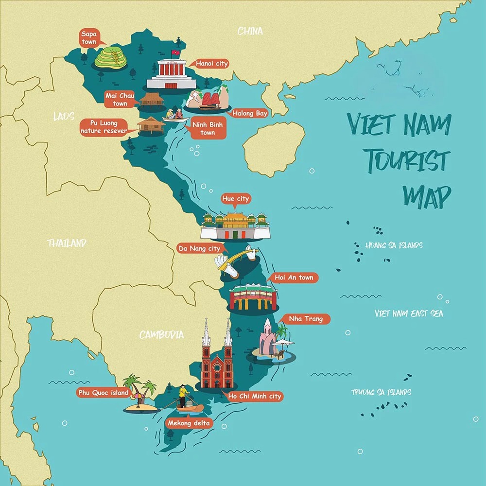
Tourism maps of Vietnam are essential for showcasing the country’s most popular attractions and destinations. They highlight UNESCO World Heritage Sites like Halong Bay, cultural landmarks such as the ancient town of Hoi An, and natural wonders like Phong Nha-Kẻ Bàng National Park.
These maps also guide visitors to beaches, trekking routes, and historical sites like the Cu Chi Tunnels and My Son Sanctuary.
In addition to highlighting key points of interest, tourism maps often include transportation routes (highways, railways, airports), accommodations, and services such as restaurants, hotels, and medical facilities. For tourists, these maps provide essential details to plan an efficient and enriching travelexperience.
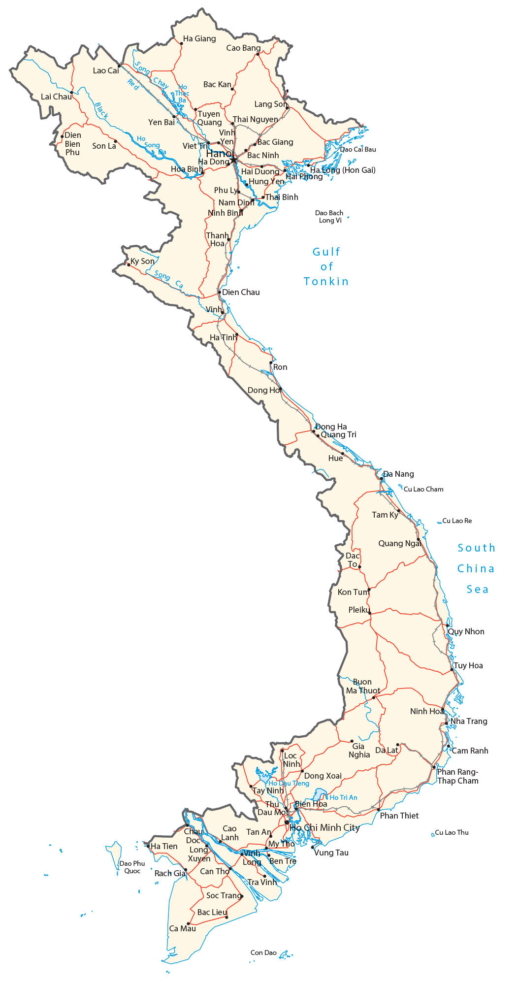
Road Map Of Vietnam
A road map of Vietnam provides a detailed view of the country's extensive transportation network, showcasing highways, local roads, railways, and important infrastructure. Vietnam has a rapidly developing road network that supports both urban and rural connectivity, and road maps are essential for navigating the country efficiently.
The primary roads are the National Routes (QH), which connect major cities, provinces, and economic hubs. National Route 1A, for example, runs from Hanoi in the north to Ho Chi Minh City in the south, serving as the backbone of the national road system.
Provincial roads and smaller rural routes are also highlighted, showing access to more remote areas, including mountainous regions and coastal towns.
Historical Map
Historical maps of Vietnam offer a visual representation of the nation's evolution, with changes in borders, territories, and political control over time. These maps document the history from the early kingdoms, through the Vietnam War, French colonial rule, and the reunification of the country in 1975.
They offer insights into Vietnam’s historical capitals, major military battles, and ancient trade routes.
For historians and scholars, historical maps are a rich resource for understanding the cultural and political shifts in Vietnam's past, such as the rise and fall of dynasties, the impact of colonialism, and the legacy of war. These maps contribute to a deeper understanding of how geography shaped the country’s history and development.
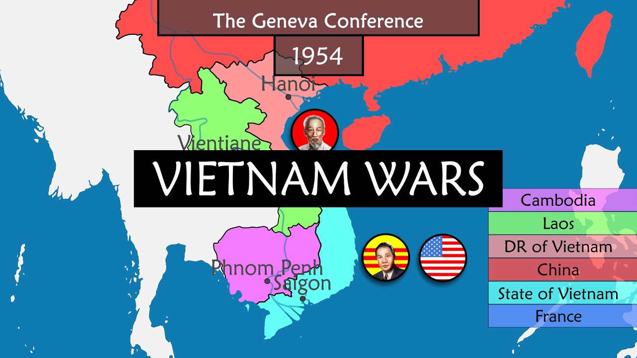
The Vietnam Wars - Summary on a Map
Vietnam Map For Travel And Tourism
Planning Routes
A travel map of Vietnam helps identify key hubs, transportation networks, and scenic routes like the Hai Van Pass. Major cities such as Hanoi, Ho Chi Minh City, and Da Nang are well-connected by highways, airports, and railways, facilitating travel through urban and rural areas.
Cultural Attractions
Tourism maps highlight cultural landmarks, UNESCO sites, festivals like Tet and the Hue Festival, and local experiences such as street food in Hanoi and the ancient temples of My Son. These maps help plan itineraries to explore Vietnam's rich history and vibrant culture.
Navigation Tips
For smooth navigation, use digital apps like Google Mapsor Maps.me, or download offline maps for rural areas. Printed maps and local transport apps are also useful for exploring cities and remote regions with limited connectivity.
Flag Of Vietnam And Symbolism

The flag of Vietnam features a red background with a large yellow five-pointed star in the center. The red color symbolizes the revolution and the bloodshed of those who fought for the country’s independence, representing the struggles of Vietnam’s history in the pursuit of freedom.
The yellow star represents the unity of the five key pillars of Vietnamese society: workers, farmers, soldiers, intellectuals, and youth. These groups collectively embody the nation’s socialist ideals, working together to build and progress Vietnam.
The simple yet profound design reflects the strength, resilience, and national pride of the Vietnamese people, showcasing their shared commitment to socialism and unity.
Fun Facts About Vietnam
1. World’s Largest Cave– Vietnam is home to Son Doong Cave, the world’s largest cave, located in Phong Nha-Kẻ Bàng National Park. The cave is so large that it has its own ecosystem, river, and weather system.
2. Vietnam’s Coffee Culture– Vietnam is the second-largest producer of coffee in the world, with its signature drink being cà phê sữa đá, iced coffee with condensed milk.
3. Over 50 Ethnic Groups– Vietnam is one of the most ethnically diverse countries in Asia, with over 50 different ethnic groups, each with unique cultures, languages, and traditions.
4. Rice Paddy Landscape– The country has some of the most stunning rice paddy landscapes in the world, with the terraced fields in places like Sapa offering a breathtaking view of rural life and agriculture.
5. World-Famous Cuisine– Vietnamese cuisine, with dishes like pho, banh mi, and spring rolls, is known for its fresh ingredients and balance of flavors. Pho is often considered a national dish.
6. Long History with Dragons– The legend of Vietnam’s origins involves a dragon, symbolizing good luck and prosperity. The dragon appears in many national symbols and even in the architecture of temples and pagodas.
7. Vietnam’s Traffic– In major cities like Hanoi and Ho Chi Minh City, motorbikes are the dominant mode of transportation, with millions of them on the roads daily, creating a unique and chaotic urban atmosphere.
8. Unique Zodiac– Vietnam follows a lunar calendar, with its own version of the zodiac that has 12 animals like the Chinese zodiac, but with a slight variation in the order and significance.
FAQs About Vietnam Map
Which Country Is Vietnam Located In?
Vietnam is a country located in Southeast Asia, bordered by China to the north, Laos and Cambodia to the west, the South China Sea to the east, and Thailand to the southwest.
What Country Is On Top Of Vietnam?
To the north of Vietnam is China, which shares a long border with Vietnam.
Where Did The Vietnam War Take Place On The Map?
The Vietnam War primarily took place in Vietnam, but also involved neighboring countries like Laos and Cambodia. Key locations included Hanoi (North Vietnam), Ho Chi Minh City (South Vietnam), and the border regions with Laos and Cambodia.
How Far Is Vietnam From Top To Bottom?
Vietnam stretches approximately 1,650 kilometers (1,025 miles) from its northern border with China to its southern tip at the Mekong Delta.
What Are The Most Important Cities To Locate On A Vietnam Map?
Hanoi, Ho Chi Minh City, Da Nang, and Hue are key cities to identify due to their cultural and economic importance.
What Is The Best Season To Travel To Vietnam?
The ideal time depends on the region, but spring (March-April) and autumn (September-November) offer pleasant weather across the country.
How Reliable Are Digital Maps In Vietnam?
Digital maps like Google Maps are generally accurate in urban areas but may lack detail in rural regions.
Are There Maps Available In English?
Yes, most tourist maps and apps provide English versions.
Conclusion
The S-shaped curve of Vietnam on the map, a graceful arc mirroring the sinuous path of a dragon, whispers tales of a nation uniquely shaped by its geography. This sinuous form isn't merely a geographical curiosity; it's a reflection of the country's dynamic character.
From the fertile embrace of the Mekong Delta, where life pulses with the rhythm of the tides, to the rugged grandeur of the Annamite Cordillera, a spine of mountains that has both sheltered and challenged its people, Vietnam's landscapes tell a story of resilience, beauty, and the enduring spirit of its inhabitants.
Jump to
Quick Facts About Vietnam
The "S" Shape Of Vietnam: A Geographical Overview
Overview Of Vietnam’s Geography
Map Of Vietnam With Cities
Regional Variations Across The Map
Types Of Vietnam Maps
Vietnam Map For Travel And Tourism
Flag Of Vietnam And Symbolism
Fun Facts About Vietnam
FAQs About Vietnam Map
Conclusion

Finn Wilde
Author
For Finn Wilde, the wilderness is more than just a destination - it’s a way of life. Over the past decade, he has led multiple expeditions in some of the world’s most remote regions, from the icy fjords of Greenland to the rugged trails of Patagonia.
Finn emphasizes sustainability in all of his adventures, helping participants connect with nature while promoting responsible exploration. His expeditions inspire individuals to explore the great outdoors while fostering a deep respect for the environment.

Michael Rachal
Reviewer
Michael Rachal believes that luxury lies in the details. With over 20 years of experience in the luxury travel industry, he has crafted hundreds of bespoke itineraries for clients seeking personalized, unforgettable experiences.
Whether guiding clients through private cultural tours or curating culinary journeys with world-renowned chefs, Michael ensures that each trip is tailored to perfection.
His ability to anticipate needs and exceed expectations has earned him a reputation as a leading expert in luxury travel.
Latest Articles
Popular Articles