Mauritius Map: A Comprehensive Guide For Travelers & Explorers
Mauritius, a paradise island in the Indian Ocean, is best explored with a map in hand. This guide will help you understand the island's geography and plan your itinerary effectively.
Author:Michael RachalReviewer:Finn WildeMay 13, 2025929 Shares116K Views
Mauritius, a stunning island nation in the Indian Ocean, is not only famous for its idyllic beachesand crystal-clear waters but also for its complex geography, cultural diversity, and vibrant tourism.
As a first-time visitor or a seasoned traveler, understanding the landscape, regions, and local infrastructure is essential for making the most out of your trip. Maps are an indispensable tool for navigating the island and uncovering its hidden gems.
Geographical Overview
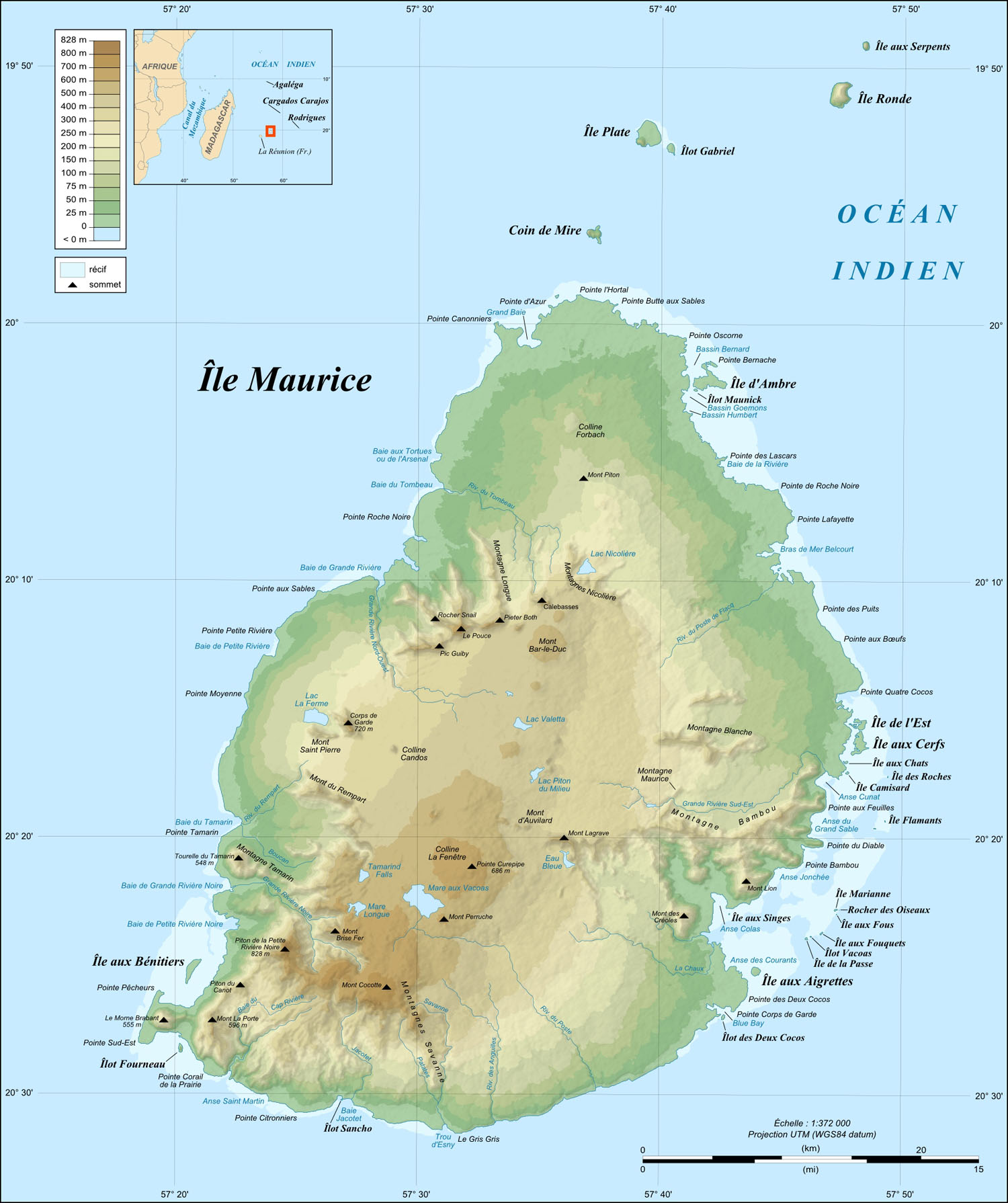
Mauritius, an island nation in the southwestern Indian Ocean, lies east of Madagascar. This small island nation, roughly the size of Maui, Hawaii, boasts a captivating blend of volcanic landscapes, lush vegetation, and vibrant coral reefs. It's part of the Mascarene Islands, a group that also includes Réunion.
The island's topography is a testament to its volcanic origins. A central plateau, formed by ancient volcanic activity, dominates the interior, while coastal plains and dramatic mountain ranges encircle the island. Mount Piton, reaching a height of 828 meters, stands as the island's highest peak.
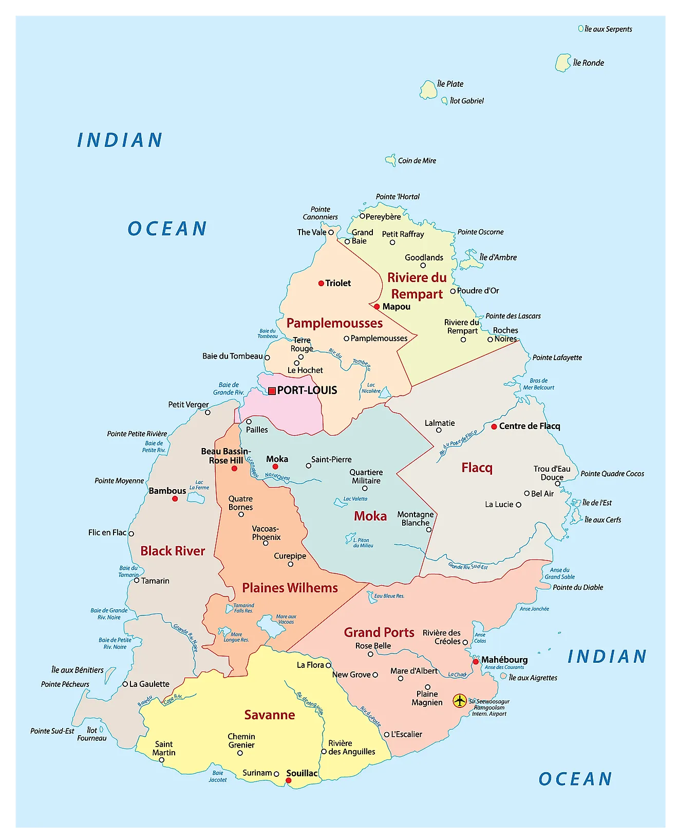
Administratively, Mauritius is divided into nine districts: Black River, Flacq, Grand Port, Moka, Pamplemousses, Plaines Wilhems, Port Louis, Rivière du Rempart, and Savanne. Each district offers a unique blend of landscapes, cultures, and attractions.
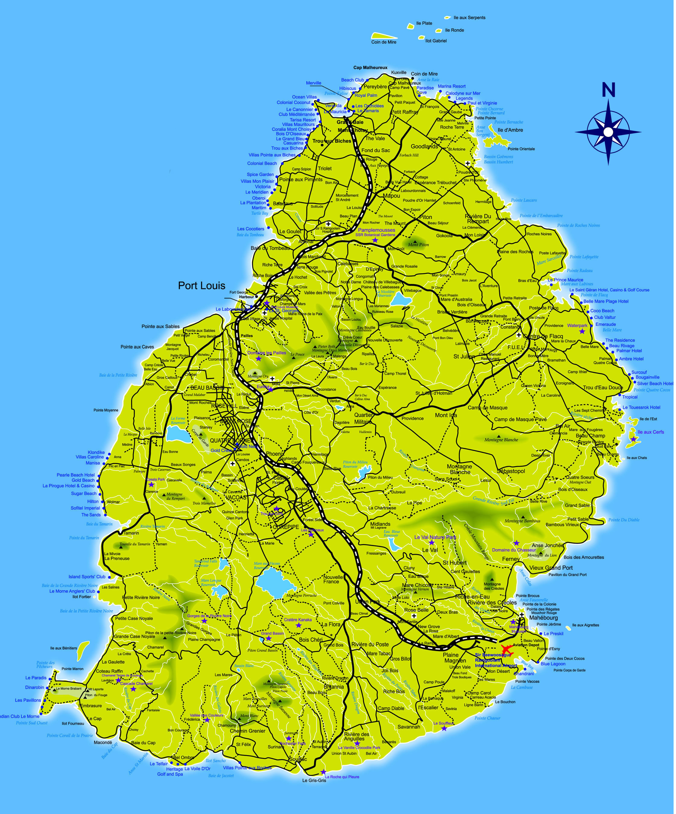
Map Of Mauritius
Key Facts About Mauritius
Before diving into the different types of maps, it's important to get familiar with some key facts about Mauritius. These facts will provide context and a deeper understanding of the island’s geography, culture, and history. The table below summarizes these quick facts:
| Fact | Details |
| Capital | Port Louis |
| Area | 2,040 km² |
| Population | 1.261 million (2023) |
| Dialing Code | +230 |
| Currency | Mauritian Rupees (MUR) |
| GDP | $14.4 Billion |
| Official Languages | English, French, Morisien |
| Time Zone | Mauritius Standard Time (MST) |
These basic facts serve as an introduction to Mauritius and will aid travelers in understanding the island's infrastructure, culture, and day-to-day life.
Map Of Mauritius With Cities
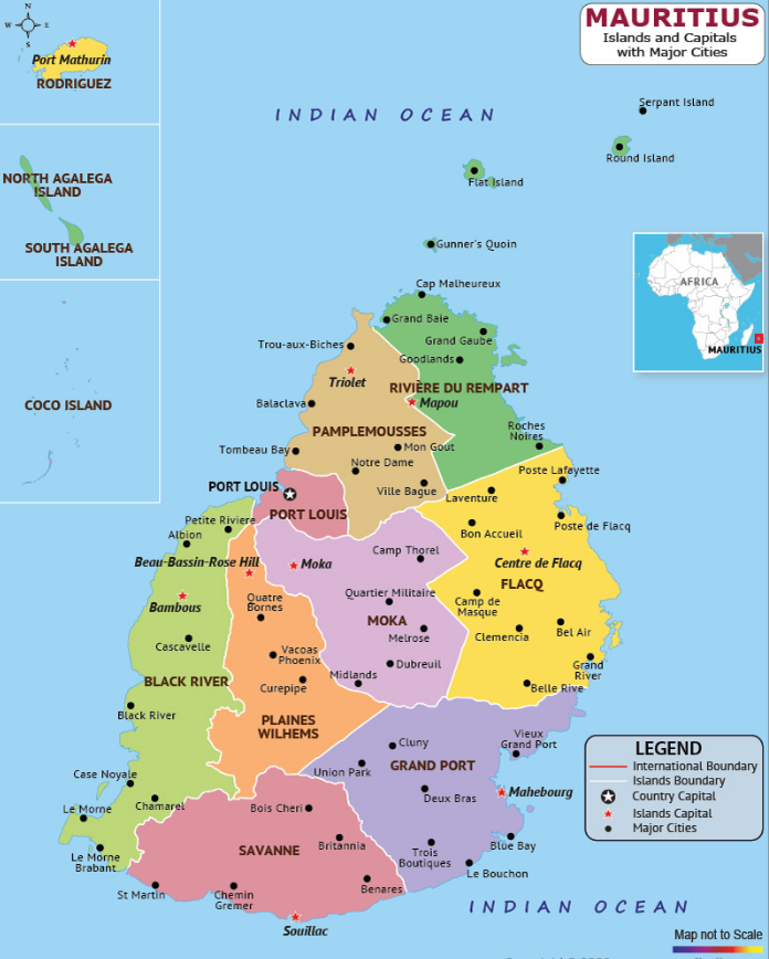
One of the first things every traveler needs when arriving in a new place is a map. Mauritius offers diverse landscapes, ranging from bustling cities to peaceful rural areas, each with its own unique charm.
A well-constructed map of Mauritius highlights the country’s main urban areas, districts, and roads, ensuring you can easily navigate between them.
Port Louis
As the capital and largest city of Mauritius, Port Louisis the economic and cultural hub of the island. It is home to the bustling Central Market, where visitors can find fresh local produce, spices, textiles, and souvenirs.
Key attractions include the Aapravasi Ghat, a UNESCO World Heritage site, and the Blue Penny Museum, which showcases the island's history and art.
Curepipe
Situated in the center of the island, Curepipeis the second-largest city of Mauritius and offers a peaceful escape from the coastal areas. Surrounded by lush greenery and rolling hills, this city is perfect for nature lovers.
Trou aux Cerfs, a dormant volcano turned crater lake, offers spectacular views of the island. Curepipe is also known for its colonial-style architecture and cool climate, thanks to its higher elevation.
Grand Baie
Located on the northwest coast, Grand Baieis arguably the most famous tourist destination in Mauritius. Known for its pristine beaches, water sports, and vibrant nightlife, it offers both relaxation and adventure. The area is also home to luxury resorts, high-end shopping, and a variety of restaurants serving international and local cuisine.
Flic-en-Flac
If you're looking for a quieter, more laid-back atmosphere with spectacular beaches, Flic-en-Flacis a perfect choice. Located on the west coast, it is known for its long stretches of white sandy beaches and clear turquoise waters.
It is also ideal for diving, snorkeling, and dolphin watching. The town is home to several beachfront resorts that offer a peaceful environment perfect for unwinding.
Quatre Bornes
Situated between Port Louis and Curepipe, Quatre Bornesis a busy town that blends both traditional and modern Mauritian life. Known for its vibrant market, it offers a mix of street vendors and boutique stores selling local art, textiles, and handmade crafts. The town is also home to various festivals throughout the year, reflecting its diverse cultural heritage.
Vacoas-Phoenix
Located in the center of the island, Vacoas-Phoenixis a large town that serves as a gateway to Black River Gorges National Parkand other outdoor attractions. Its cool climate and proximity to nature reserves make it a fantastic spot for eco-tourism and hiking. The area also has a variety of local amenities, making it a popular residential area for locals.
These cities and others like Bel Ombre, Trou d'Eau Douce, and Vacoas form the heart of Mauritius, catering to a mix of locals and tourists. The map is crucial to understanding the country's layout, helping you travelbetween cities and popular spots efficiently.
Map Of Mauritius (Political)
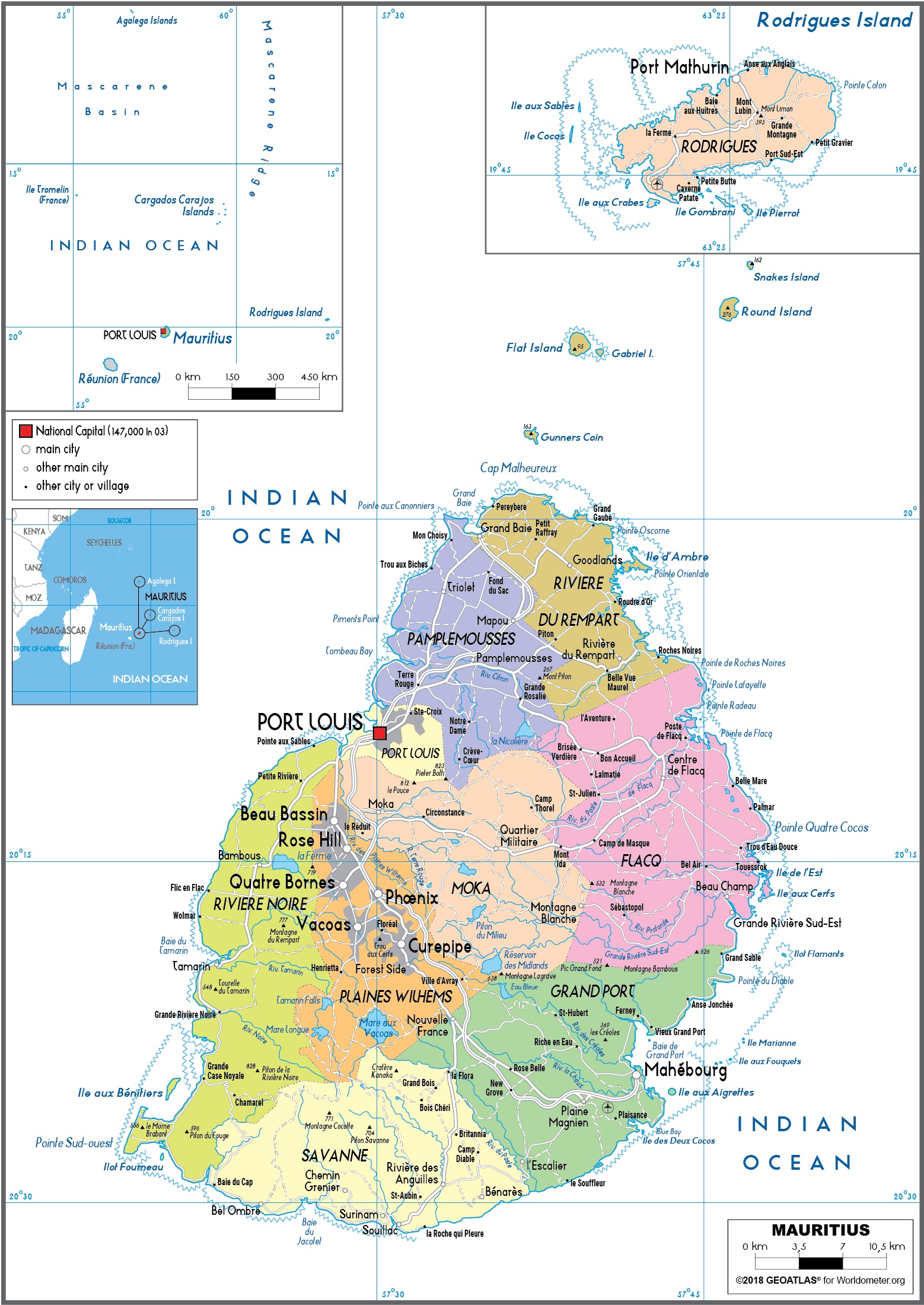
The political map of Mauritius outlines the nine districts and their capitals, showcasing the administrative divisions of the island. Key districts include:
- Port Louis: The bustling capital city, known for its markets and colonial architecture.
- Flacq: Home to beautiful beaches and local markets.
- Black River: Famous for Black River Gorges National Park and scenic landscapes.
- Grand Port: The historic landing point of Dutch settlers in 1598.
- Moka: A central district known for its cultural and educational institutions.
Each district offers unique experiences, and understanding their locations can enhance your travel planning.
Climate Map Of Mauritius
Mauritius’ tropical climate makes it a popular year-round destination, although there are certain seasons to be mindful of. The island experiences two main seasons:
- Summer (November to April): Hot and humid, with the possibility of cyclones, especially between January and March. Average temperatures range between 25°C and 35°C.
- Winter (May to October): Cooler and drier, with temperatures averaging between 18°C and 24°C, making it ideal for outdoor activities.
A climate mapof Mauritius provides insights into the temperature variations across different regions. Coastal areas tend to be warmer, while the central plateau experiences cooler temperatures due to higher elevations.
Travelers can plan their trips according to this map, ensuring they visit at the most suitable time based on their preferred weather conditions.
For example, those seeking warmer weather might opt for the summer months (November to April), while those who prefer cooler temperatures might enjoy the winter months (May to October). However, it's crucial to be aware of the cyclone season, which typically occurs from November to April.
Map Of Mauritius' Holiday Resorts

Mauritius is known for its luxury resorts, stunning beaches, and family-friendly destinations. A resort map is a great way to explore where to stay depending on your travel preferences.
Some of the most popular resort areas include:
- Grand Baie: Offers a mix of luxurious resorts, beaches, and vibrant nightlife. Ideal for those who enjoy a lively environment.
- Flic-en-Flac: A serene beach town with high-end resorts, perfect for honeymooners or couples looking for a peaceful getaway.
- Belle Mare: Known for its pristine white-sand beaches and five-star resorts, ideal for families.
- Le Morne: Offers a variety of luxury resorts, located near the UNESCO World Heritage site Le Morne Brabant.
Resort Map Highlights: By using a detailed map, visitors can easily locate their resorts in these regions, ensuring quick access to beaches, dining, and activities. Be sure to explore both the luxurious and more affordable options available across the island.
Types Of Maps You Might Need In Mauritius
Understanding the different types of maps available for Mauritius will help you navigate the island with ease:
Road Map
Purpose: A road map is indispensable if you plan to rent a car, use taxis, or explore the island's scenic routes.
Features:
- Highlights highways, major roads, and secondary routes.
- Shows fuel stations, parking areas, and scenic drives like the Coastal Road.
- Includes key landmarks and towns for easy navigation.
Where to Get It: Available at car rental agencies, airports, and tourist information centers.
Topographic Map
Purpose: Ideal for adventure enthusiasts and nature lovers planning to hike or explore natural parks.
Features:
- Detailed elevation levels, contour lines, and geographical features.
- Highlights popular hiking spots like Black River Gorges National Park, Le Morne Brabant, and Trou aux Cerfs.
- Includes rivers, forests, and volcanic features of the island.
Where to Get It: Purchase from local bookshops, hiking gear stores, or download specialized hiking apps.
Public Transport Map
Purpose: A must for travelers relying on Mauritius’ affordable bus system.
Features:
- Displays bus routes, stops, and hubs like Victoria Bus Terminalin Port Louis.
- Includes information on timings, major connections, and destinations covered by buses.
- Useful for navigating towns and cities without a car.
Where to Get It: Found at bus stations, tourist offices, or downloadable online.
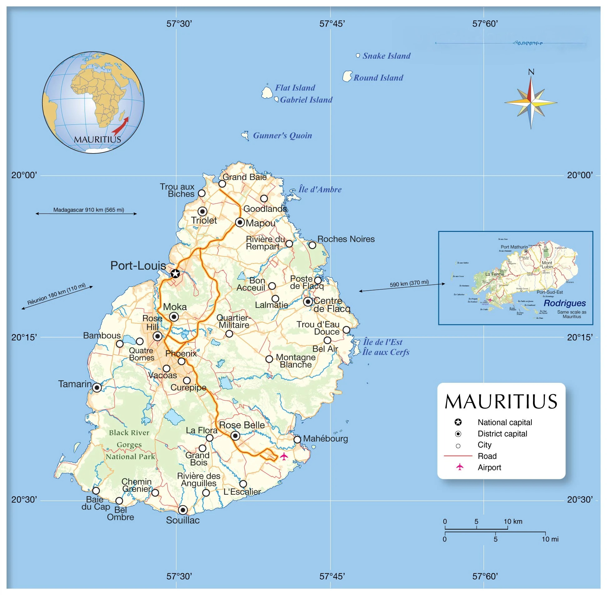
Locator Map Of Mauritius
Mauritius is located approximately 910 km (565 miles) east of Madagascar and about 2,000 km (1,243 miles) off the southeastern coast of Africa. The island is part of the Mascarene Archipelago, which also includes Rodrigues and Réunion.
A locator map is invaluable for visualizing its position within the Indian Ocean and its proximity to neighboring countries and islands.
Map Of Rodrigues Islands
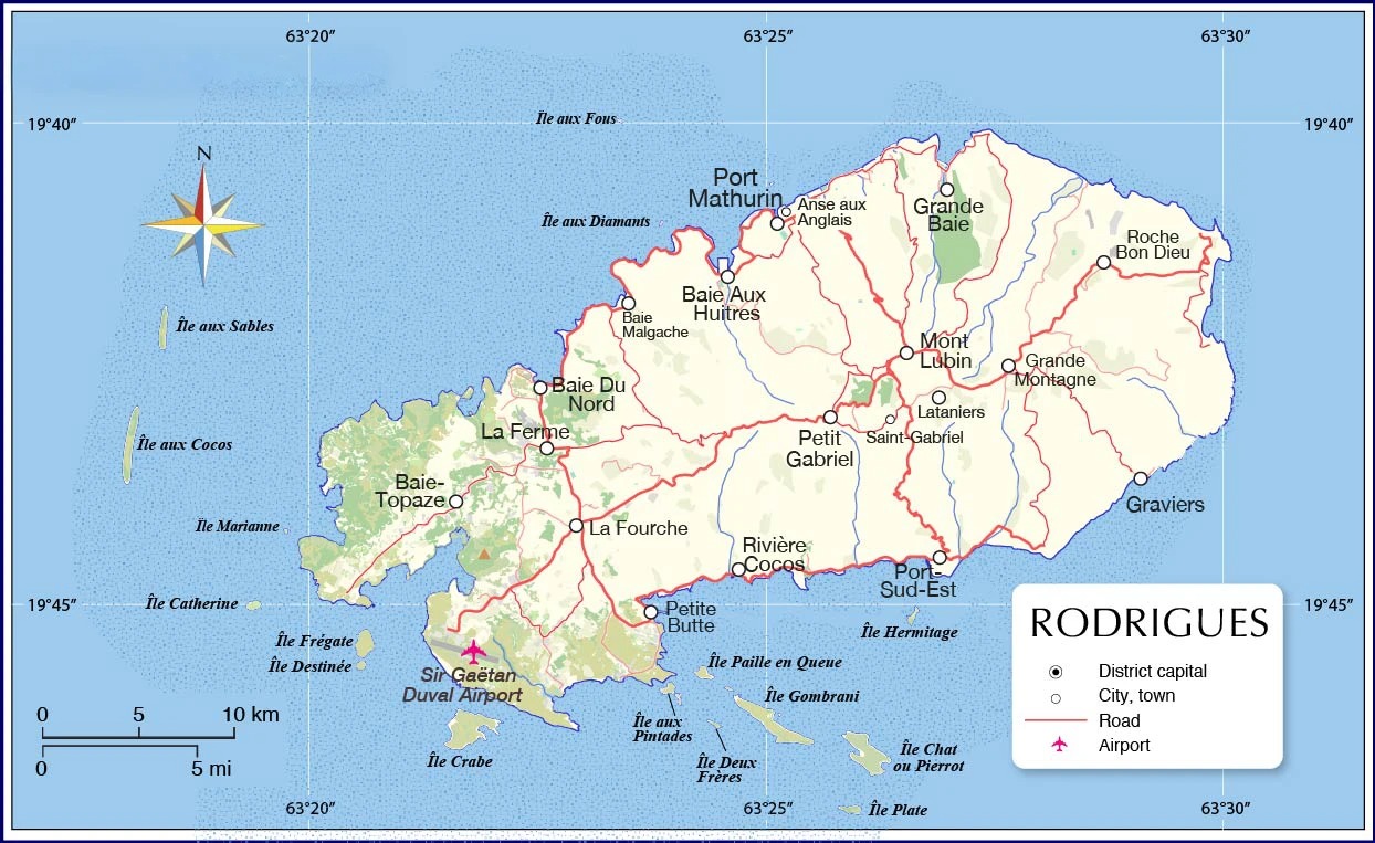
Rodrigues, the "jewel in the crown" of Mauritius, lies about 560 km (348 miles) to the northeast of the main island. It is a volcanic island, much smaller in size, with a tranquil atmosphere. Key features of Rodrigues include:
- Port Mathurin: The capital and administrative center.
- Beaches: Such as Trou d’Argent and St. Francois.
- Nature Reserves: Including François Leguat Reserve, known for its giant tortoises.
A dedicated map of Rodrigues highlights its towns, beaches, and natural attractions, making it easier for visitors to explore.
Interactive/Online Maps
Purpose: The go-to option for tech-savvy travelers who prefer real-time navigation.
Features:
- Apps like Google Mapsprovide turn-by-turn navigation, reviews for restaurants and attractions, and offline map download options.
- Specialized apps such as Maps.Meor Mauritius-specific tourism apps provide more detailed local information.
- Real-time traffic updates and alternative routes.
- Includes points of interest like beaches, historical sites, and shopping areas.
Advantages:
- Crucial in areas with limited signage.
- Offline capabilities help in regions with poor internet connectivity, such as mountainous areas or remote beaches.
Where to Get It: Available for free on app stores or provided by local tourism boards.
Top Tourist Attractions In Mauritius

Mauritius is home to several top-tier tourist attractions that are essential for any traveler. A map marking these locations will allow visitors to plan their trips effectively. Some of the must-see attractions include:
- Le Morne Brabant: A UNESCO World Heritage site, this mountain is famous for its historical significance and its scenic beauty.
- Black River Gorges National Park: Known for hiking, wildlife, and stunning waterfalls, this park is a haven for nature lovers.
- Pamplemousses Botanical Garden: A lush garden featuring a variety of indigenous and exotic plants, including giant water lilies and the talipot palm.
- Chamarel Waterfall: A breathtaking waterfall located in the southwest, surrounded by a dramatic landscape.
- La Vanille Nature Park: A great family-friendly attraction home to giant tortoises, crocodiles, and other wildlife.
Flag Of Mauritius
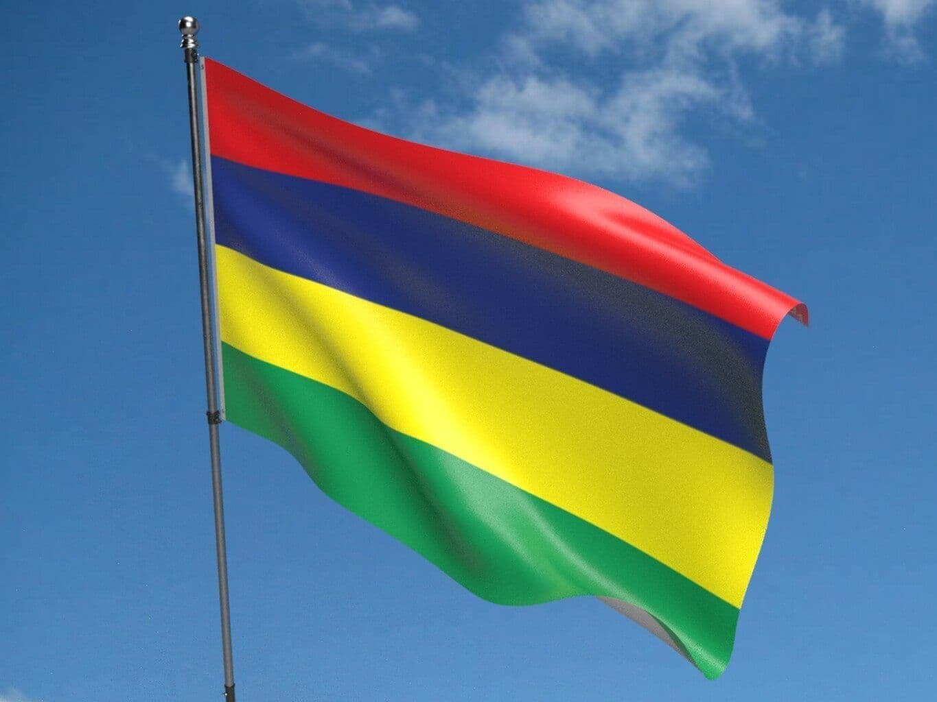
The flag of Mauritius is an emblem of the nation’s diverse and rich heritage. Comprised of four horizontal stripes, each color holds significant meaning:
- Red: Represents the struggle for independence and the blood shed for freedom.
- Blue: Represents the Indian Ocean, which surrounds the island.
- Yellow: Symbolizes the bright future of the island.
- Green: Reflects the island's agriculture and its role in sustaining the population.
The flag is an important cultural symbol, representing the unity and diversity of the people of Mauritius.
Fun Facts About Mauritius
Mauritius is not just a beautiful island but also a place full of fascinating facts:
- The Dodo's Legacy:Mauritius was home to the now-extinct dodo bird, which has become a symbol of the island's unique biodiversity.
- A Multicultural Society:The population of Mauritius is a harmonious blend of Indian, African, Chinese, and European cultures.
- Home to UNESCO Sites:Le Morne Brabant, a rugged mountain, is a UNESCO World Heritage Site that symbolizes the fight for freedom by escaped slaves.
- Vanishing Island:Île aux Serpents, once part of Mauritius, has submerged underwater due to rising sea levels.
- One of the World's Smallest Countries:Covering just 2,040 square kilometers, Mauritius is one of the smallest nations globally.
- A Meteorological Marvel:The island experiences microclimates, with sunny beaches and rainy mountains existing just a short drive apart.
FAQs About Mauritius Maps
Which Country Is Mauritius Located In?
Mauritius is an independent island nation located in the Indian Ocean, off the southeastern coast of Africa. While it is not part of any other country, it is situated approximately 2,000 kilometers (1,243 miles) from mainland Africa and closest to Madagascar.
Is Mauritius Cheap?
The cost of visiting Mauritius can vary based on your travel preferences. While it offers luxury resorts and fine dining, it also provides affordable guesthouses and street food options for budget travelers. Public transport is inexpensive, but imported goods and activities like diving can be pricier.
What Are The Main Districts Of Mauritius?
Mauritius is divided into nine districts, each with its own charm and purpose. The main districts are Port Louis (the capital), Black River, Moka, Flacq, and Grand Port. Each district offers a unique experience, from urban centers to rural towns and breathtaking nature reserves.
What Are The Best Tourist Regions In Mauritius For A First-time Visit?
For first-time visitors, the best regions to explore are Grand Baie, Flic-en-Flac, and Port Louis. These areas offer a mix of beach resorts, shopping, dining, and cultural attractions.
Are There Any Specialized Maps For Eco-tourism?
Yes! Eco-tourism maps of Mauritius are designed to help visitors explore nature reserves, national parks, and protected marine areas. These maps highlight trails, wildlife habitats, and eco-friendly accommodations.
What’s The Best Way To Use Online Maps For Navigating Mauritius?
Using online maps like Google Maps or tourism apps is the most effective way to navigate Mauritius. These platforms offer detailed information on routes, attractions, accommodations, and real-time updates on traffic and public transport.
Conclusion
In conclusion, a map of Mauritius is more than just a tool to get around-it’s an essential part of your travel experience. From understanding the geography of the island to locating the best resorts and tourist attractions, maps will make your trip more enjoyable and efficient. By leveraging these maps, you can navigate the island’s diverse landscapes, plan your routes, and ensure that you don’t miss out on any of the island’s many wonders.
Planning your trip with the right maps will help you make the most of your time in Mauritius, ensuring a seamless and memorable experience.
Jump to
Geographical Overview
Map Of Mauritius
Key Facts About Mauritius
Map Of Mauritius With Cities
Map Of Mauritius (Political)
Climate Map Of Mauritius
Map Of Mauritius' Holiday Resorts
Types Of Maps You Might Need In Mauritius
Top Tourist Attractions In Mauritius
Flag Of Mauritius
Fun Facts About Mauritius
FAQs About Mauritius Maps
Conclusion

Michael Rachal
Author
Michael Rachal believes that luxury lies in the details. With over 20 years of experience in the luxury travel industry, he has crafted hundreds of bespoke itineraries for clients seeking personalized, unforgettable experiences.
Whether guiding clients through private cultural tours or curating culinary journeys with world-renowned chefs, Michael ensures that each trip is tailored to perfection.
His ability to anticipate needs and exceed expectations has earned him a reputation as a leading expert in luxury travel.

Finn Wilde
Reviewer
For Finn Wilde, the wilderness is more than just a destination - it’s a way of life. Over the past decade, he has led multiple expeditions in some of the world’s most remote regions, from the icy fjords of Greenland to the rugged trails of Patagonia.
Finn emphasizes sustainability in all of his adventures, helping participants connect with nature while promoting responsible exploration. His expeditions inspire individuals to explore the great outdoors while fostering a deep respect for the environment.
Latest Articles
Popular Articles