Ireland Map - History, Flag, Capital, And Fascinating Facts
Learn what makes Ireland extraordinary. This map reveals its history, culture, and natural beauty in one handy guide.
Author:Finn WildeReviewer:Michael RachalJan 19, 2025103.4K Shares1.4M Views
Ireland, which is frequently referred to as the Emerald Isle because of its verdant surroundings, provides a fascinating fusion of culture, history, and scenic beauty.
Knowing Ireland's geography through its map is crucial, if you're touring its energetic cities, seeing historic sites, or just traveling through its stunning countryside. Ireland's geographical structure, regions, cities, natural wonders, and much more will be thoroughly examined in this article.
Quick Facts About Ireland
- Capital: Dublin
- Official Languages: Irish (Gaelic) and English
- Currency: Euro (€) in the Republic of Ireland, Pounds Sterling (£) in Northern Ireland
- Population: Approximately 5 million people
- Area: 84,421 square kilometers
- Time Zone: GMT (Greenwich Mean Time) / IST (Irish Standard Time) in summer
- Country Code: +353
- Famous Landmarks: Cliffs of Moher, Giant’s Causeway, Dublin Castle, Killarney National Park
- Popular Foods: Irish stew, soda bread, and seafood chowder
- Climate: Mild, temperate maritime climate with cool winters and mild summers
- National Parks: Six parks, including Killarney and Wicklow Mountains National Park
- Flag: Green, white, and orange vertical stripes
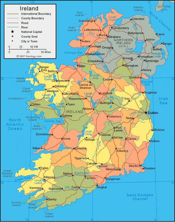
Geographical Overview Of Ireland
Ireland is a beautiful island off the coast of Europe. It's known for its rolling green hills, rugged coastlines, and stunning space.
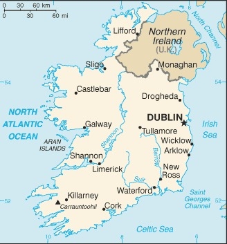
Think of Ireland as two countries on one island: the Republic of Ireland and Northern Ireland. Northern Ireland is part of the United Kingdom, while the Republic of Ireland is an independent country.
The Irish landscape is truly breathtaking. You'll find mountains like the Macgillycuddy Reeks, which are the highest in Ireland, and beautiful valleys and rivers throughout the country. The River Shannon, the longest river in Ireland, flows through the heart of the island.
History Of Ireland’s Maps
For centuries, people have been trying to map Ireland. Early maps, mostly created for military and government use, weren't always accurate. They were often more like artistic impressions than precise representations of the land.
Things changed significantly in the 19th century with the start of the Ordnance Survey. This meticulous mapping project laid the groundwork for the detailed maps we use today.
In recent decades, technology has revolutionized how we map Ireland. With tools like Geographic Information Systems (GIS), we can create incredibly detailed and accurate maps.
These maps show everything from cities and towns to rivers, mountains, and even the smallest roads. This technology is incredibly valuable for travelers, planners, and researchers who need precise and up-to-date information about the Irish landscape.
Map Of Ireland Cities
1. Dublin
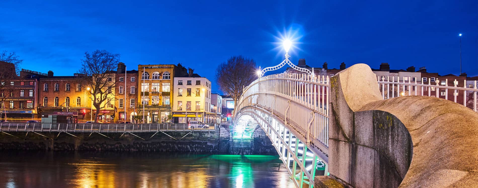
Dublin, Ireland's bustling capital, is a city where history and modern life come together. Located on the east coast, it's the biggest city in the country and the heart of Irish culture.
Dublin has a rich literary tradition, with famous writers like James Joyce and Samuel Beckett having lived and worked there. You can visit iconic landmarks like Trinity College, home to the incredible Book of Kells, check out Dublin Castle, and admire the grandeur of St. Patrick's Cathedral.
Dublin is a lively city with a vibrant nightlife, traditional pubs, and a thriving arts scene. It's a place you won't want to miss.
2. Cork
Located in the south of Ireland, Cork is often referred to as the "Rebel City" due to its historical role in Irish uprisings. Cork is famous for its vibrant food culture, with many excellent restaurants and food markets like the English Market.
The city is steeped in history, with Blarney Castle and the Blarney Stone attracting visitors from all over the world. Its location near the scenic Ring of Kerry and other beautiful landscapes makes it a popular base for exploring the Irish countryside.
3. Galway
On the west coast of Ireland, Galway is celebrated for its vibrant arts scene, rich cultural heritage, and bohemian charm. The renowned Galway Arts Festival brings together artists and performers from across the globe, creating an atmosphere that is both lively and inspiring.
Strolling through Galway’s colorful streets, visitors are treated to traditional Irish music, inviting pubs, and unique shops. For those planning their trips, considering options like the best credit cards for travel rewardscan make the experience even more enjoyable and budget-friendly. Meanwhile, the rugged beauty of Connemara and the nearby Aran Islands offers an escape into Ireland’s stunning natural landscapes.
4. Limerick
Situated in the Midwest of Ireland, Limerick is known for its medieval history and modern cultural offerings. The city is home to King John’s Castle, a 13th-century fortress overlooking the River Shannon, and St. Mary’s Cathedral, an example of stunning Gothic architecture.
Limerick is also a hub for arts, theater, and music, with numerous galleries, festivals, and performances throughout the year. Its blend of history and modernity makes Limerick a dynamic and exciting city to visit.
5. Waterford
Waterford holds the title of Ireland’s oldest city, with a rich Viking heritage dating back to the 9th century. Located in the southeast of the country, it’s known for its history, medieval architecture, and as the home of the world-famous Waterford Crystal.
The city’s Viking Triangle, with attractions such as the Reginald’s Tower and Waterford Treasures Museum, offers visitors a glimpse into the city’s ancient past. Today, Waterford continues to be an important cultural and industrial center, making it a fascinating destination for history enthusiasts.
Regions On The Map Of Ireland

Ireland is divided into four provinces, which are further subdivided into counties. The provinces are historical and cultural regions, each offering distinct landscapes and traditions. Here are the four provinces of Ireland:
1. Leinster
Located in the eastern part of the island, Leinster is home to Dublin, the capital city, and is the most populous province in Ireland. It is known for its cultural and historical landmarks, including Newgrange (a 5,000-year-old passage tomb), as well as its modern economic influence.
2. Munster
Situated in the south, Munster is famous for its stunning coastline, including the Ring of Kerry, the Cliffs of Moher, and the picturesque towns of Killarney and Cobh. The province also has a rich history, with castles, cathedrals, and ancient ruins dotting the landscape.
3. Connacht
Located in the west, Connacht is known for its rugged terrain, with spectacular natural features such as the Burren in County Clare and Connemara’s remote wilderness. Galway, one of Ireland’s most cultural cities, is also in this province.
4. Ulster
Ulster is located in the north and is the only province with a portion of its territory in Northern Ireland. The province is known for its breathtaking landscapes, including Giant’s Causeway and Lough Neagh. Ulster is also home to the historic city of Derry and the capital of Northern Ireland, Belfast.
Capital Of Ireland
Dublin serves as the capital of the Republic of Ireland. It is the country’s political, economic, and cultural center. With a population of over 1.3 million people, Dublin is Ireland’s largest city, located on the east coast of the island, along the River Liffey.
Visitors to Dublin will find a mix of modern architecture and historic landmarks, including the Book of Kells at Trinity College, Dublin Castle, The Guinness Storehouse, and Temple Bar, an area known for its nightlife and pubs. Dublin is also a hub for the technology sector, with multinational companies such as Google, Facebook, and Twitter establishing their European headquarters in the city.
Population Of Ireland
The population of the Republic of Irelandis estimated at 5 million people. This population is spread across urban areas, with Dublinbeing the most populous city, followed by cities such as Cork, Limerick, and Galway. Ireland's population has grown steadily in recent decades, due to factors such as immigration, a growing economy, and improving living standards.
In Northern Ireland, which is part of the United Kingdom, the population is approximately 1.9 millionpeople. The total population of the entire island of Ireland (both the Republic and Northern Ireland) stands at around 6.9 million.
Currency Of Ireland
The Republic of Ireland uses the Euro (€)as its official currency. However, in Northern Ireland, which is part of the United Kingdom, the currency used is the Pound Sterling (£). Visitors traveling between the Republic and Northern Ireland should be mindful of this currency difference.
The Euro is divided into 100 cents, and ATMsare widely available throughout both regions of the island.
Dialing Code Of Ireland
The international dialing code for the Republic of Irelandis +353. This code is required when dialing from outside Ireland. The dialing code for Northern Ireland is +44, as it is part of the United Kingdom. It is important to use the correct country code depending on which part of Ireland you are calling.
Language Of Ireland
Ireland has two official languages: Irish (Gaeilge)and English. While Irish is a compulsory subject in schools and is used in some government settings, the majority of the population speaks Englishas their primary language.
Irish is spoken more widely in specific regions, particularly in the Gaeltacht, or Irish-speaking areas, such as parts of County Galway, County Kerry, and County Donegal. In these regions, you may see road signs and place names written in both Irish and English.
Flag Of Ireland
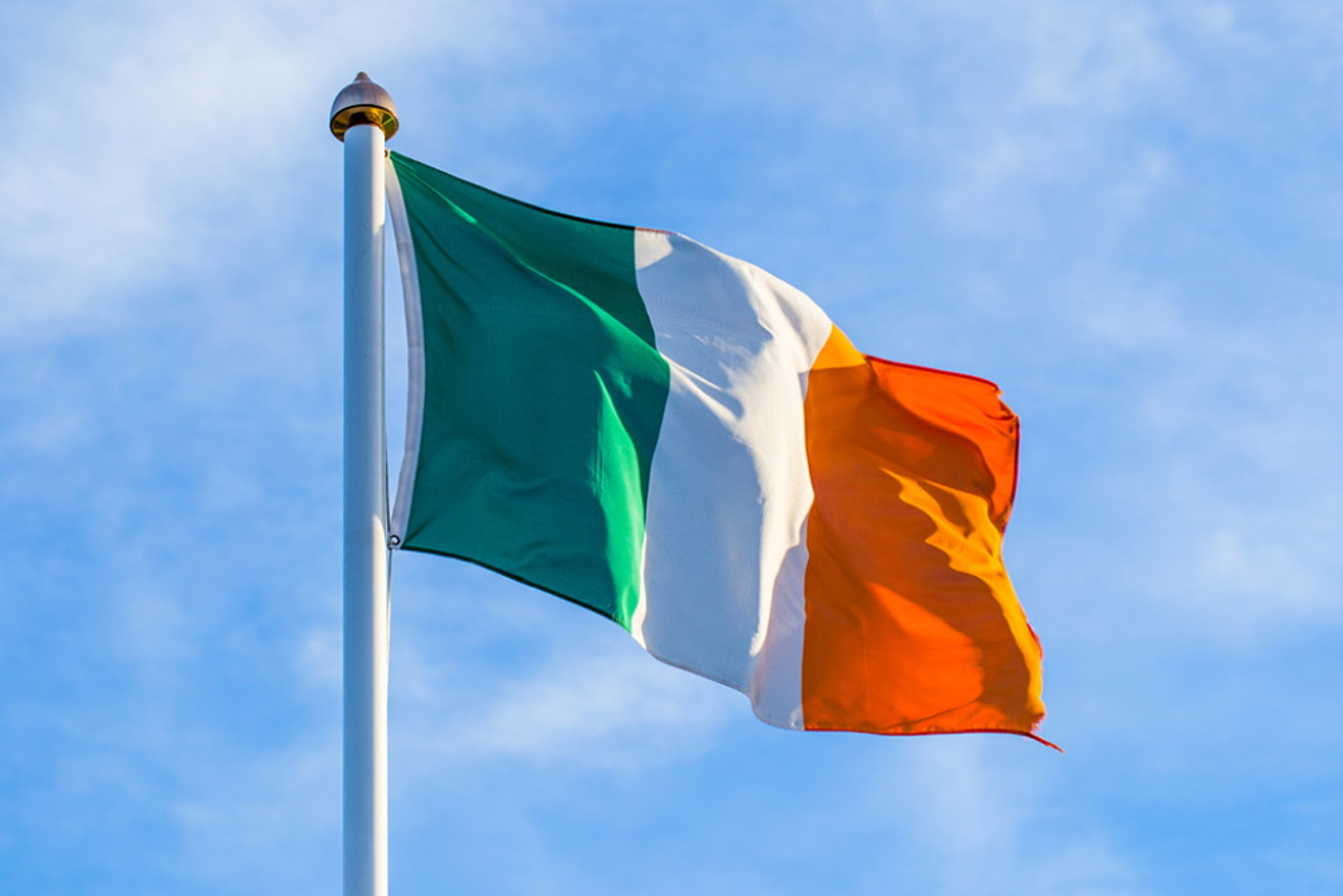
The national flag of Irelandconsists of three vertical stripes: green, white, and orange. The green represents Irish Catholics and nationalists, while the orange symbolizes Irish Protestants and unionists. The white stripe in the center stands for peace and unity between the two groups.
The flag was first adopted during the Irish Rebellion of 1798 and has since become a symbol of the nation’s independence and its aspirations for unity.
Government Type Of Ireland
Ireland is a parliamentary democracywith a republican systemof government. The head of state is the President of Ireland, elected by the public every seven years. The head of government is the Taoiseach (Prime Minister), who is appointed by the President, usually the leader of the largest party in the Dáil Éireann (House of Representatives).
Ireland operates under a Constitution, which was enacted in 1937, and the parliament, known as the Oireachtas, consists of two chambers: the Dáil Éireann and the Seanad Éireann (Senate).
Total Area Of Ireland
The total area of Irelandis 84,421 square kilometers (32,595 square miles). The Republic of Ireland occupies the majority of the island, while Northern Ireland makes up the northeastern part, which is approximately 14% of the island's total area.
Ireland is a country of diverse landscapes, including mountains, rivers, lakes, and a rugged coastline that stretches over 7,500 kilometers. It is one of the most beautiful countries in the world, offering a wide variety of outdoor activities for nature lovers and travelers.
Historical And Cultural Landmarks
Ireland is a country steeped in history, and its map is dotted with ancient and cultural landmarks. Some of the most notable landmarks include:
- Newgrange: This 5,000-year-old tomb in County Meath is older than the pyramids of Egypt and is a UNESCO World Heritage Site.
- The Cliffs of Moher: Located in County Clare, these stunning cliffs rise 214 meters above the Atlantic Ocean and offer breathtaking views of the coastline.
- Blarney Castle: Famous for the Blarney Stone, which grants the gift of eloquence to those who kiss it, this historic castle is located near Cork.
- Kilmainham Gaol: A former prison in Dublin, this landmark played a significant role in Irish history, particularly during the struggle for independence.
Ireland’s Natural Wonders On The Map
1. The Burren
Located in County Clare, the Burren is a vast karst landscape that stretches across the region. Its striking limestone pavements, created by the erosion of the rocks, make it a geological wonder. The Burren is not only visually impressive but also a haven for nature enthusiasts.
It is home to a mix of rare plants and wildlife, including species from both the Arctic and Mediterranean climates. The Burren is a paradise for botanists and nature lovers who will appreciate its unique biodiversity and the surreal beauty of its landscape.
2. Giant’s Causeway
Giant’s Causeway, located in Northern Ireland, is one of the most iconic natural landmarks in Ireland and is recognized as a UNESCO World Heritage Site. This extraordinary geological formation consists of around 40,000 interlocking basalt columns formed by ancient volcanic activity.
The columns, which range in height and shape, create a fascinating and otherworldly appearance. According to legend, the causeway was built by the giant Finn McCool, adding an element of myth and mystery to this stunning natural wonder.
3. Killarney National Park
Nestled in County Kerry, Killarney National Park is Ireland’s first national park and one of its most popular natural attractions. The park is famous for its serene lakes, rugged mountains, and lush woodlands, making it a popular destination for outdoor activities such as hiking, cycling, and boating.
The park is also home to a diverse range of wildlife, including deer, eagles, and otters. Among the highlights are the stunning Lough Leane, Muckross House, and the dramatic Torc Waterfall.
Ireland’s Ancient Sites On Maps
Ireland is a country with a rich history, and its landscape is dotted with numerous ancient sites that have stood the test of time. Many of these sites are of significant historical, cultural, and spiritual importance. Here are some prominent ancient sites you can find on maps of Ireland:
- Newgrange(County Meath): A 5,000-year-old passage tombolder than the pyramids of Egypt, Newgrange is part of the Brú na BóinneUNESCO World Heritage Site. The structure is renowned for its winter solstice phenomenon, where sunlight illuminates the chamber inside.
- The Hill of Tara(County Meath): Once the seat of the High Kings of Ireland, Tara is a large archaeological complex with ancient burial mounds and standing stones, marking the center of Ireland’s ancient kingdom.
- The Rock of Cashel(County Tipperary): A stunning complex of medieval buildings perched on a limestone hill, this historic site includes a cathedral, round tower, and Cormac’s Chapel, among other structures.
- Celtic Crosses(Various locations): Ireland is famous for its unique Celtic crosses, which dot the landscape and can be found in churches, monasteries, and graveyards across the island.
These ancient sites are located throughout the country, each with a deep historical connection to Ireland's past.
Regional Cuisine Maps
- Dublin: Dublin is known for its modern dining scene, but traditional dishes like Irish stew, coddle, and boxty(potato pancakes) are staples here.
- Cork: The county is famous for seafood, with dishes like Cork oystersand Irish musselsbeing popular in the area. Cork’s English Marketis also known for selling regional products, including Blarney black pudding.
- Connacht: Connachtis known for its wild game, including venison, as well as potatoesand cabbage, which are staple ingredients in the local diet.
- Kerry: Known for its fresh seafood, Kerry lamb, and potatoes, this region also boasts unique dishes like Kerry blue cheeseand Kerry gold butter.
- Northern Ireland: Famous for Ulster Fry, a hearty breakfast including sausages, bacon, eggs, black pudding, and soda bread.
Wildlife And Biodiversity Maps
- Red Deer: Ireland is one of the few countries in Europe where the red deercan be found in the wild, particularly in Killarney National Park.
- Irish Hare: This native species, known for its long legs and distinctive ear shape, can be found in the Irish countryside.
- Puffins and Seabirds: Ireland’s coastal cliffs are home to a variety of seabirds, including puffins, seagulls, and kittiwakes.
- Bottlenose Dolphins: The Wild Atlantic Wayprovides a perfect habitat for dolphins and other marine life, and Dingle Bayis a popular location to see these creatures.
National Parks On The Map Of Ireland
1. Killarney National Park (County Kerry)
Ireland’s first national park, established in 1932, is located in County Kerry. It features an incredible combination of lakes, mountains, and forests. The park is home to Muckross House, Torc Waterfall, and the famous Lakes of Killarney, offering picturesque settings for hiking, cycling, and boating. Wildlife enthusiasts can spot red deer and rare bird species in this serene haven.
2. Glenveagh National Park (County Donegal)
Situated in County Donegal, Glenveagh National Park is known for its rugged mountain scenery, rolling valleys, and pristine lakes. It’s a paradise for hikers and photographers. The park also boasts Glenveagh Castle, surrounded by beautiful gardens, and is home to diverse wildlife, including the golden eagle.
3. Connemara National Park (County Galway)
Located in County Galway, this park is famous for its wild, rugged terrain. Connemara National Park is a haven for hikers, offering trails that range from easy walks to challenging climbs, including the ascent of Diamond Hill, which provides panoramic views of the surrounding landscapes. The park is also rich in flora and fauna, including Connemara ponies and rare plant species.
4. Wicklow Mountains National Park (County Wicklow)
Stretching across County Wicklow, this park is known for its expansive forests, glacial valleys, and tranquil lakes. Highlights include the Glendalough Monastic Site, Powerscourt Waterfall, and countless walking trails suitable for all levels of fitness. It’s a favorite destination for hikers and history buffs alike.
5. The Burren National Park (County Clare)
Located in the heart of the Burrenregion in County Clare, this park is celebrated for its unique limestone landscape. The Burren National Park is a biodiversity hotspot, home to rare plant species and an unusual mix of Arctic and Mediterranean flora. Visitors can enjoy guided walks, explore caves, or marvel at the park's unusual rocky terrain.
6. Phoenix Park (Dublin)
One of the largest urban parks in Europe, Phoenix Park spans over 1,700 acres in Dublin. It’s an oasis of green within the city and home to herds of wild deer. The park features landmarks such as the Áras an Uachtaráin(the residence of the Irish president) and the Dublin Zoo, making it a popular spot for families, joggers, and picnickers.
Seasonal Highlights On The Map
- Spring: Best for witnessing Ireland’s wildflowers and lush green landscapes, particularly in Killarney and Connemara.
- Summer: Ideal for visiting the Wild Atlantic Way, coastal regions, and festivals like the Galway Arts Festivaland Cork Jazz Festival.
- Autumn: The changing foliage in regions like the Wicklow Mountainsand Dublin’s Phoenix Parkprovides stunning autumn colors.
- Winter: Famous for Christmas markets and festivals, Dublin and Galwayshine with holiday decorations, while Cork’sshops provide warm, cozy atmospheres.
Famous Filming Locations On The Map Of Ireland
- Game of Thrones: Many scenes were filmed in Northern Irelandat locations like Dark Hedges(the Kingsroad) and Ballintoy(Iron Islands).
- Star Wars: The Skellig Islandsoff the coast of County Kerry were used as Luke Skywalker’s hideout in The Force Awakens.
- Harry Potter: The Cliffs of Moherappeared in the Harry Potter and the Half-Blood Princeas the location of the Horcrux cave.
- The Quiet Man: Filmed in County Galway, this beloved classic showcased Ireland’s scenic countryside.
Climate Map Of Ireland
Ireland experiences a temperate maritime climate, characterized by mild winters and cool summers. The climate map of Irelandillustrates regional variations, with the west experiencing wetter weather due to the proximity to the Atlantic Ocean, while the east is relatively drier.
- West Coast: More rainfall and cooler temperatures, with areas like Galwayand Corkreceiving around 1,200mm to 1,600mm of rain per year.
- East Coast: Dublin and surrounding areas have a drier climate, with around 750mm to 1,000mm of rainfall annually.
Ireland’s climate is conducive to agriculture, particularly the cultivation of crops like potatoes and barley, and helps create its lush, green landscape.
Ireland’s Borders And Neighboring Countries
Ireland shares its border only with Northern Ireland, which is part of the United Kingdom. The Republic of Ireland is separated from Great Britain by the Irish Sea, which lies to the east. Ireland’s total land area is 84,421 square kilometers, and it is one of the closest countries to mainland Europe. The country’s unique geographic position has historically made it a hub for travel diplomacy, fostering connections and relationships across Europe and beyond.
Travel Safety Map Tips
- Driving: Ireland drives on the left side of the road, and some rural roads can be narrow, requiring extra caution.
- Weather: While the climate is generally mild, it’s important to carry weather-appropriate clothing, as rain can be frequent, especially on the west coast.
- Emergency Numbers: The emergency number for police, fire, and ambulance services is 112.
Travelsafety maps help highlight areas of high tourist activity, local medical services, and recommended routes for drivers. For anyone planning an unforgettable journey, Ireland travelresources often include detailed safety maps to ensure a smooth and enjoyable trip across the Emerald Isle.
Interesting Facts About Ireland
- Ireland has no snakes, it’s believed that St. Patrick banished them.
- The leprechaunis an iconic figure in Irish mythology.
- Dublin’s Book of Kellsis one of the world’s oldest illuminated manuscripts.
- The Irish languagehas survived for over 2,000 years.
- Ireland’s national symbolis the shamrock.
- The longest place namein Ireland is Muckanaghederdauhaulia.
- Ireland is home to the oldest barin the world; Sean’s Barin Athlone.
- The Cliffs of Moherare 700 feet tall.
- The Irish are among the largest drinkers of teain the world.
- Ireland has over 30,000 castles.
- The first countryin the world to elect an openly gay head of state was Ireland.
- Ireland is known for its literary greatslike James Joyce, W.B. Yeats, and Oscar Wilde.
- St. Patrick’s Dayis celebrated worldwide, but it’s a public holiday only in Ireland.
- Ireland has over 30,000 miles of coastline.
- The famous Irish pub culture is an integral part of Ireland’s social life.
FAQs
What Is The Best Time To Visit Ireland?
The best time to visit Ireland is during the summer months (June to August) when the weather is mild and festivals are in full swing. However, spring (April to June) and autumn (September to October) are also great times to visit for fewer crowds and pleasant weather.
Do I Need A Visa To Visit Ireland?
Citizens of the EU and EEA countries do not need a visa to visit Ireland. For other nationalities, including U.S. citizens, Ireland offers visa-free entry for short visits (up to 90 days). However, it’s always best to check with the Irish embassy for specific visa requirements.
Is It Expensive To Travel In Ireland?
Ireland can be on the expensive side, especially in cities like Dublin. Accommodation, food, and attractions may cost more, but there are plenty of ways to save money by choosing budget accommodations, eating in local pubs, and exploring free attractions like Parks and Historical Sites.
What Is Ireland Famous For?
Ireland is famous for its rich history, mythology, green landscapes, and friendly people. Popular cultural elements include Guinness beer, Irish whiskey, Celtic music, literary giants, and iconic landmarks like the Cliffs of Moher and the Giant’s Causeway.
Are There Any Famous Festivals In Ireland?
Yes, Ireland is known for its festivals, including St. Patrick’s Day (March 17), Galway Arts Festival (July), Cork Jazz Festival (October), and Dublin Theatre Festival (September). Each of these festivals highlights Ireland's music, arts, culture, and food.
Final Words
Ireland is a truly magical place! It's a country filled with history, stunning landscapes, and a warm, welcoming spirit. From ancient castles to marveling at the breathtaking Cliffs of Moher, there's something for everyone.
You can wander through vibrant cities, hike through breathtaking national parks, and indulge in delicious Irish food and drinks. Ireland is a country that will capture your heart. With its friendly people and unforgettable experiences, you'll create memories that will last a lifetime.
Jump to
Quick Facts About Ireland
Geographical Overview Of Ireland
History Of Ireland’s Maps
Map Of Ireland Cities
Regions On The Map Of Ireland
Capital Of Ireland
Population Of Ireland
Currency Of Ireland
Dialing Code Of Ireland
Language Of Ireland
Flag Of Ireland
Government Type Of Ireland
Total Area Of Ireland
Historical And Cultural Landmarks
Ireland’s Natural Wonders On The Map
Ireland’s Ancient Sites On Maps
Regional Cuisine Maps
Wildlife And Biodiversity Maps
National Parks On The Map Of Ireland
Seasonal Highlights On The Map
Famous Filming Locations On The Map Of Ireland
Climate Map Of Ireland
Ireland’s Borders And Neighboring Countries
Travel Safety Map Tips
Interesting Facts About Ireland
FAQs
Final Words

Finn Wilde
Author
For Finn Wilde, the wilderness is more than just a destination - it’s a way of life. Over the past decade, he has led multiple expeditions in some of the world’s most remote regions, from the icy fjords of Greenland to the rugged trails of Patagonia.
Finn emphasizes sustainability in all of his adventures, helping participants connect with nature while promoting responsible exploration. His expeditions inspire individuals to explore the great outdoors while fostering a deep respect for the environment.

Michael Rachal
Reviewer
Michael Rachal believes that luxury lies in the details. With over 20 years of experience in the luxury travel industry, he has crafted hundreds of bespoke itineraries for clients seeking personalized, unforgettable experiences.
Whether guiding clients through private cultural tours or curating culinary journeys with world-renowned chefs, Michael ensures that each trip is tailored to perfection.
His ability to anticipate needs and exceed expectations has earned him a reputation as a leading expert in luxury travel.
Latest Articles
Popular Articles