Map Of Andorra - Cities, History, And Points Of Interest
Andorra is a hidden gem in the Pyrenees, and a good map can help you unlock its beauty. From scenic mountain views to charming villages, here’s everything you need to know.
Author:Michael RachalReviewer:Finn WildeDec 19, 20244.2K Shares262.9K Views
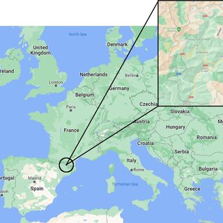
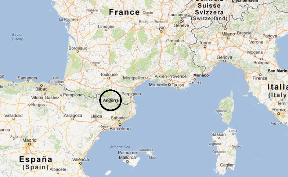
Tucked away in the Pyrenees between Spain and France, Andorra is a hidden gem often overlooked on European maps. Its striking landscapes, intricate road networks, and compact yet diverse layout make it a fascinating country to navigate.
Understanding the map of Andorranot only reveals its geographical charm but also offers practical insights for travelers, adventurers, and anyone curious about this unique microstate.
From its mountainous terrain to its bustling capital, every detail on the map tells a story of Andorra’s culture, history, and way of life. This article serves as a comprehensive guide to help you uncover everything you need to know about Andorra’s maps and how to use them effectively.
Quick Facts About Andorra
- Location:Nestled in the Pyrenees Mountains between Spain and France.
- Capital:Andorra la Vella – the highest capital city in Europe.
- Area:468 square kilometers – one of Europe’s smallest countries.
- Population:Approximately 79,000 people.
- Official Language:Catalan, with Spanish, French, and Portuguese widely spoken.
- Currency:Euro (€), despite not being an EU member.
- Government:Parliamentary co-principality with two heads of state – the President of France and the Bishop of Urgell (Spain).
- Economy:Relies on tourism (80% of GDP), duty-free shopping, and financial services.
- Key Attractions:Ski resorts (Grandvalira, Vallnord), Madriu-Perafita-Claror Valley (UNESCO site).
Geographical Overview Of Andorra
Andorra spans just 468 square kilometers, making it one of Europe’s smallest countries. Perched high in the Pyrenees, it enjoys a stunning mountainous landscape that defines its borders and influences its economy. At an elevation of over 1,000 meters, Andorra is a haven for winter sports enthusiasts, boasting some of the best ski resorts in Europe.
In fact, Andorra ranks among the best places to travel in January, offering ideal conditions for skiing and winter adventures. The country is divided into seven parishes, or parroquias, each with its own unique charm. Andorra la Vella, the capital, is both a cultural and commercial hub. From picturesque valleys to alpine lakes, the geography of Andorra is a blend of natural beauty and strategic significance.
What Makes Andorra’s Map Unique?
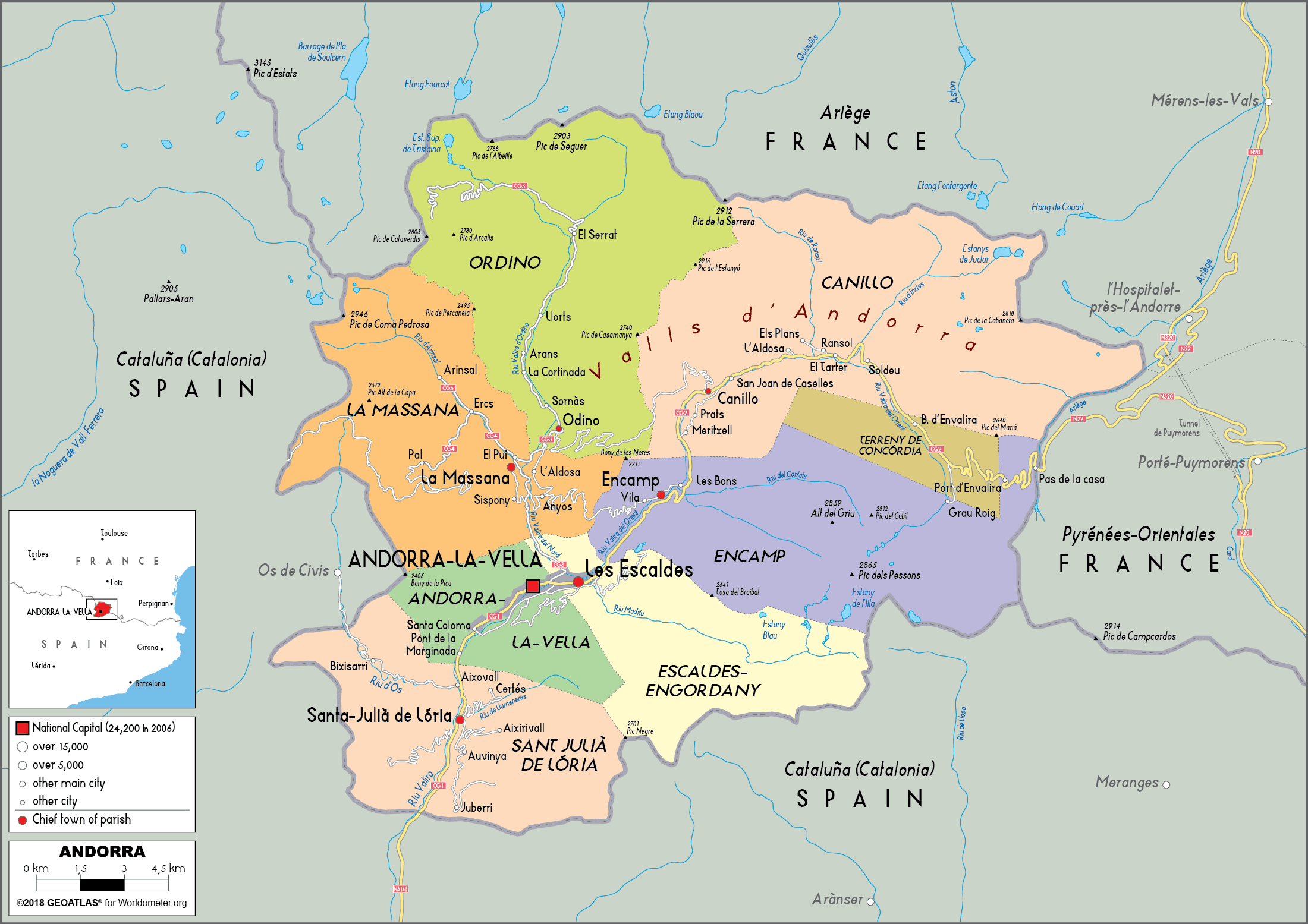
The map of Andorra stands out for its compact yet intricate design. Despite its small size, the country’s map is densely packed with natural landmarks, urban centers, and transportation routes that cater to locals and tourists alike.
1. Seven Parishes
The administrative division into seven parishes: Canillo, Encamp, Ordino, La Massana, Andorra la Vella, Sant Julià de Lòria, and Escaldes-Engordany offers a glimpse into the cultural and historical diversity within the nation.
2. Landmarks
- Andorra la Vella:The bustling capital and a hub for shopping and culture.
- Grandvalira and Vallnord:Renowned ski resorts marked prominently on tourist maps.
- Madriu-Perafita-Claror Valley:A UNESCO World Heritage site that reflects the country’s commitment to preserving its natural heritage.
3. Transport Routes
The map reveals a network of well-maintained roads connecting Andorra to Spain and France. The CG-1and CG-2highways are major arteries for trade and travel.
Map Of Andorra Cities
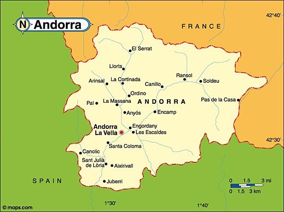
1. Andorra La Vella
As the capital city, Andorra la Vella is the political, cultural, and economic heart of the country. Located at an elevation of 1,023 meters, it is Europe’s highest capital city. The city is famous for its:
- Bustling shopping streets filled with duty-free stores.
- Historical sites such as Casa de la Vall, a 16th-century building once used as the parliament house.
- Vibrant nightlife, dining options, and cultural events.
2. Escaldes-Engordany
Adjacent to Andorra la Vella, Escaldes-Engordany is renowned for its natural hot springs and wellness tourism. The town is home to:
- Caldea Spa Complex, one of Europe’s largest thermal spas.
- Art galleries and modern architecture showcasing Andorra’s contemporary side.
- Scenic walking routes connecting to surrounding nature.
3. Encamp
Encamp serves as a gateway to the Grandvalira Ski Resort, one of Andorra’s major attractions. It’s a charming town with:
- A blend of modern and traditional architecture.
- Museums such as the National Automobile Museumshowcasing vintage cars.
- Access to ski lifts and hiking trails that make it a hub for outdoor activities.
4. Canillo
Located in a picturesque valley, Canillo is a serene town ideal for nature lovers. It is famous for:
- Sant Joan de Caselles, a Romanesque church dating back to the 11th century.
- Proximity to Grandvalira, offering skiing, snowboarding, and mountain biking.
- A tranquil atmosphere, making it a favorite among families and relaxation seekers.
5. La Massana
La Massana is a lively town and a top destination for outdoor enthusiasts. Highlights include:
- Direct access to Vallnord Ski Resort, which caters to winter sports and summer activities like mountain biking.
- Traditional Andorran houses and a welcoming local vibe.
- Coma Pedrosa Natural Park, home to the highest peak in Andorra, Coma Pedrosa (2,942 meters).
6. Ordino
Known as the cultural hub of Andorra, Ordino is steeped in history and tradition. It is notable for:
- The Museu Casa d’Areny-Plandolit, a 19th-century aristocratic home showcasing Andorran heritage.
- Idyllic surroundings, including green valleys and picturesque trails.
- Its peaceful ambiance, ideal for those seeking a slower pace.
7. Sant Julià De Lòria
Located near the Spanish border, Sant Julià de Lòria serves as a major entry point into Andorra. It is known for:
- Naturland, an adventure park offering year-round activities like tobogganing and hiking.
- A mix of commercial and residential areas.
- Scenic views of surrounding valleys and easy access to neighboring towns.
Regions On The Map Of Andorra
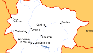
Andorra is divided into seven parishes(parroquias), each with its distinct identity and attractions. These parishes serve as administrative, cultural, and tourism hubs, offering a diverse range of experiences for visitors and locals alike.
1. Canillo
Canillo is the largest parish by area and a gateway to Andorra’s natural wonders. Located in the northeastern part of the country, it is renowned for its picturesque landscapes and serene environment.
Highlights:
- Grandvalira Ski Resort:One of the largest ski areas in Europe.
- Sant Joan de Caselles:An 11th-century Romanesque church with stunning frescoes.
- Ice Palace (Palau de Gel):A year-round ice-skating and sports facility.
2. Encamp
Situated near the heart of Andorra, Encamp combines a modern vibe with historical charm. It is often regarded as the country’s ski and hiking capital.
Highlights:
- Funicamp Cable Car:A 6-kilometer gondola offering direct access to Grandvalira’s slopes.
- National Automobile Museum:Featuring a unique collection of vintage vehicles.
- Scenic trails that lead to breathtaking mountain views.
3. Ordino
Known as the cultural and historical center of Andorra, Ordino is a tranquil parish with a deep connection to Andorran heritage.
Highlights:
- Museu Casa d’Areny-Plandolit:A museum showcasing the lifestyle of Andorra’s aristocracy.
- Vallnord Ski Resort (Ordino-Arcalís):Famous for its freeride skiing and breathtaking scenery.
- Natural Beauty:Surrounded by lush valleys and peaceful walking trails.
4. La Massana
La Massana is a lively parish located in the western part of Andorra. It is a hub for outdoor enthusiasts, offering activities throughout the year.
Highlights:
- Vallnord Ski Resort (Pal-Arinsal):Perfect for skiing, snowboarding, and mountain biking.
- Coma Pedrosa Natural Park:Home to Andorra’s highest peak, Coma Pedrosa (2,942 meters).
- A charming mix of traditional architecture and modern amenities.
5. Andorra La Vella
As the smallest yet most populous parish, Andorra la Vella serves as the country’s capital and economic center.
Highlights:
- Casa de la Vall:A historical parliament building dating back to the 16th century.
- Avinguda Meritxell:A shopping street famous for its duty-free stores.
- A vibrant blend of cultural landmarks and urban attractions.
6. Sant Julià De Lòria
Situated near the Spanish border, Sant Julià de Lòria is the southernmost parish and a gateway for cross-border travelers.
Highlights:
- Naturland:An adventure park offering activities such as tobogganing, hiking, and nature exploration.
- University of Andorra:The only university in the country, located in this parish.
- A mix of cultural events and picturesque views.
7. Escaldes-Engordany
Escaldes-Engordany is known for its natural hot springs and modern urban development. It offers a perfect blend of relaxation and cultural exploration.
Highlights:
- Caldea Thermal Spa:Europe’s largest thermal spa, offering a luxurious wellness experience.
- Valira River:Flowing through the parish, adding to its scenic beauty.
- A thriving arts and culture scene with numerous galleries and exhibitions.
Population Of Andorra
With a population of approximately 79,000 people, Andorra is one of the least populous countries in Europe. Its demographic composition reflects a blend of cultures, with native Andorrans accounting for about 33% of the population. The rest comprises residents from neighboring Spain and France, along with Portuguese and other international communities.
Currency Of Andorra
Andorra adopted the Euro (€)as its official currency, despite not being a member of the European Union. This unique arrangement is rooted in its historical and economic ties with Spain and France, both of which use the Euro. Before the Euro, Andorra accepted both French francs and Spanish pesetas due to its lack of a national currency.
Dialing Code Of Andorra
Andorra’s international dialing code is +376, a unique identifier that doesn’t require any additional country prefix. This standalone code simplifies communication for residents, businesses, and tourists. Andorra’s telecommunication infrastructure is modern, with high-speed internet and reliable mobile networks available throughout the country.
Language Of Andorra
The official language of Andorra is Catalan, reflecting its deep cultural ties to Catalonia. Catalan is used in government, education, and media, making it a cornerstone of Andorran identity. In addition to Catalan, Spanish, French, and Portugueseare widely spoken, reflecting the country’s multicultural population and geographic location.
Flag Of Andorra
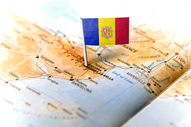
The flag of Andorraconsists of three vertical stripes in blue, yellow, and red, symbolizing its historical connections with both France and Spain. At the center of the yellow stripe lies Andorra’s coat of arms, featuring a shield divided into four quadrants. The shield includes a mitre and crosier, representing the Bishop of Urgell, and two red cows, symbolizing the Count of Foix.
Government Of Andorra
Andorra operates under a parliamentary co-principality, a unique form of governance shared between two co-princes: the President of France and the Bishop of Urgell, Spain.
This system dates back to a medieval agreement ensuring Andorra’s independence while acknowledging its powerful neighbors. Legislative authority resides in the General Council, which comprises elected representatives responsible for passing laws and managing the country’s budget.
Total Area Of Andorra
Andorra spans a total area of 468 square kilometers, making it the sixth-smallest country in Europe. Despite its small size, Andorra’s landscape is remarkably diverse, featuring towering mountains, lush valleys, and crystal-clear lakes.
Types Of Maps You’ll Find Of Andorra
1. Political Maps
These maps outline Andorra’s administrative boundaries, showcasing its seven parishes and their respective capitals. They are essential for understanding local governance and jurisdiction.
2. Physical Maps
Physical maps highlight the country’s terrain, including its peaks, valleys, rivers, and forests. They’re particularly useful for hikers and adventure enthusiasts planning to explore Andorra’s outdoors.
3. Tourist Maps
Designed for visitors, these maps feature key attractions, ski resorts, cultural landmarks, and hiking trails. They often include additional details like accommodations and dining options.
4. Digital Maps And GPS
Modern navigation tools like Google Maps and offline GPS apps provide interactive features, making it easier than ever to explore Andorra. These tools are especially handy for finding lesser-known paths and routes.
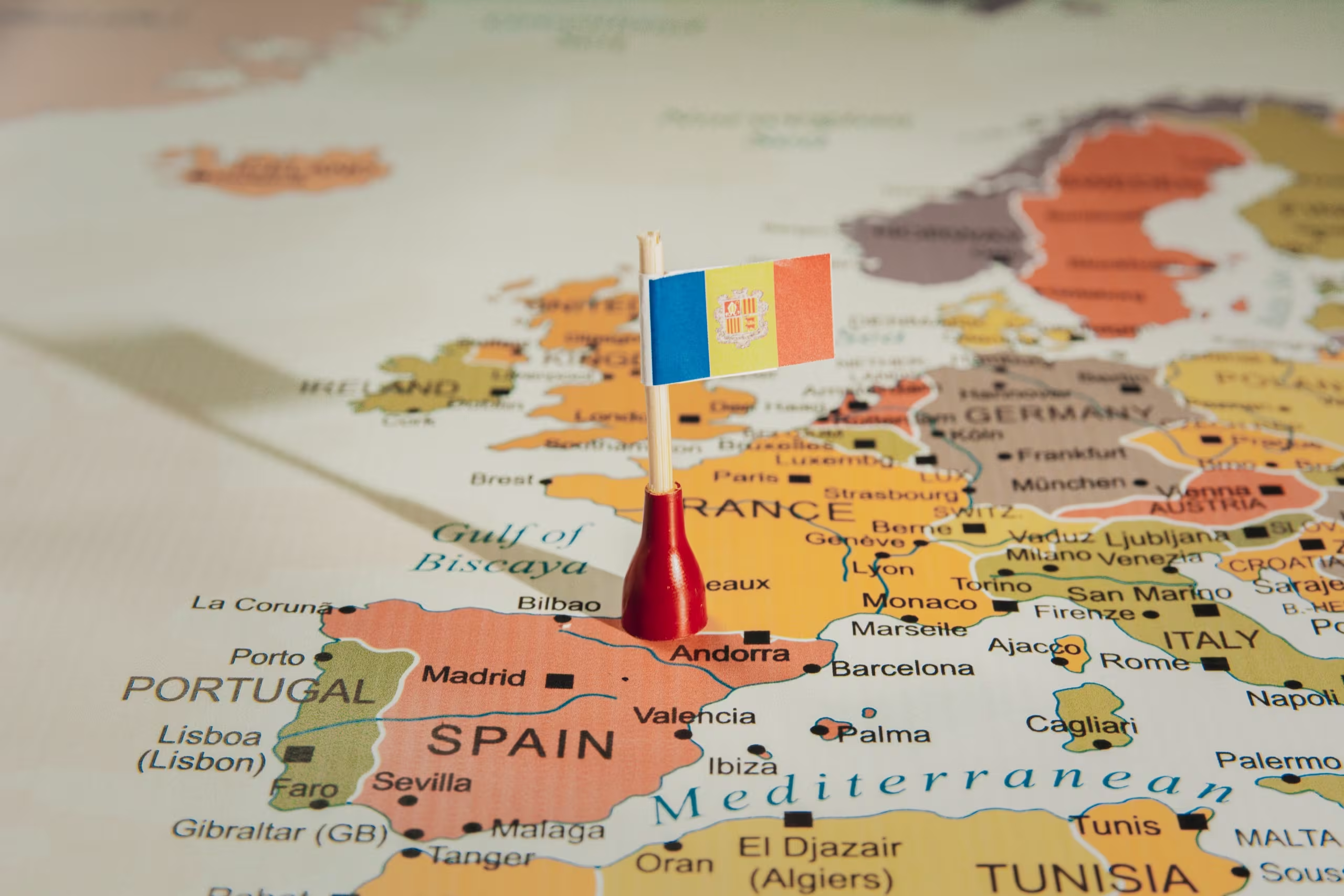
Andorra’s Borders And Neighboring Countries
Andorra is a landlocked microstate situated in the eastern Pyrenees Mountains, sharing borders with two countries:
- Spain to the south
- France to the north
Despite its small size, Andorra's geographical position between these two nations has significantly influenced its culture, economy, and governance.
1. Border With Spain
The southern border with Spain stretches for approximately 63 kilometers, offering several points of entry. The most notable is the Farga de Moles border crossing, which connects Andorra to the Catalan region of Spain via the CG-1 highway. This crossing is a vital route for trade, tourism, and daily commuting, as many Spanish residents work in Andorra.
- Spanish influence is evident in Andorra’s cuisine, language (Spanish is widely spoken), and economic ties.
- Visitors often cross the Spanish border to shop in Andorra, take advantage of its duty-free status, or access its ski resorts.
2. Border With France
To the north, Andorra shares a 56-kilometer border with France. The Pas de la Casa border crossing, accessible via the CG-2 highway, is the main point of entry. This route connects Andorra to the French region of Occitanie and is particularly popular among winter sports enthusiasts traveling to Andorra’s renowned ski areas.
- French influence is visible in Andorra’s architecture, gastronomy, and cultural traditions.
- The northern border also sees significant cross-border trade and tourism, particularly during the winter ski season.
3. Ease Of Navigation
Both borders are well-marked and managed with modern infrastructure, making them easy to navigate. Customs checks are relatively straightforward due to Andorra’s duty-free economy, though certain restrictions apply to goods like tobacco and alcohol. While Andorra may not have direct access to ports, its proximity to major coastal areas makes it a unique addition to European cruise travel destinations, especially for those looking to explore inland wonders.
- Roads connecting Andorra to its neighbors are well-maintained, ensuring smooth travel year-round.
- Seasonal conditions, such as snow in the winter, can occasionally impact road accessibility, but the government ensures prompt maintenance to minimize disruptions.
National Parks And Landscapes In Andorra
1. Madriu-Perafita-Claror Valley
The Madriu-Perafita-Claror Valleyis Andorra’s most renowned natural area and a UNESCO World Heritage Site. Covering nearly 10% of the country’s territory, this valley is a symbol of Andorra’s commitment to preserving its natural heritage.
Highlights:
- Pristine Landscapes:Featuring glacial valleys, alpine meadows, and dense forests.
- Cultural Heritage:The valley contains ancient stone huts, dry stone walls, and evidence of centuries-old pastoral traditions.
- Hiking Paradise:Trails like the GR7 and GR11 pass through the valley, offering routes for beginners and seasoned hikers.This untouched wilderness is ideal for eco-tourism, connecting visitors with the serene beauty of Andorra’s high-altitude terrain.
2. Coma Pedrosa Natural Park
Named after Andorra’s highest peak, Coma Pedrosa (2,942 meters), this park is a must-visit for mountaineers and adventure enthusiasts. Located near La Massana, it offers spectacular views and challenging terrain. For those seeking a more refined escape, Andorra is also known for its luxury travel destinations, offering a perfect blend of adventure and indulgence.
Highlights:
- Peak Experiences:The climb to Coma Pedrosa rewards hikers with panoramic views of the Pyrenees.
- Lakes and Waterfalls:Glacial lakes like Estanys de Baiau add to the park’s charm.
- Diverse Flora and Fauna:The park is home to endangered species like the Pyrenean desman and golden eagle.Coma Pedrosa Natural Park is ideal for those seeking a rugged and remote outdoor adventure.
3. Sorteny Valley Natural Park
Known for its biodiversity, Sorteny Valley Natural Parkis a haven for botanists and wildlife enthusiasts. Located in the parish of Ordino, it covers an area of approximately 1,080 hectares.
Highlights:
- Rare Plant Species:Over 800 species of flora, including medicinal plants, thrive here.
- Gentle Hiking Trails:Family-friendly trails like the Sorteny Valley Route allow visitors to explore the park’s natural beauty.
- Wildlife Spotting:Look for chamois, marmots, and birds of prey as you explore.This park’s rich biodiversity makes it a favorite among eco-tourists and families.
Andorra’s Natural Wonders On The Map
1. Lake Engolasters
Located near Escaldes-Engordany, Lake Engolastersis a stunning glacial lake at an altitude of 1,616 meters. It is a popular destination for both locals and tourists due to its accessibility and tranquil surroundings.
Highlights:
- Scenic Beauty:The lake is surrounded by lush pine forests and offers breathtaking views of the valley below.
- Hiking and Walking:Easy trails around the lake make it ideal for families and casual hikers.
- Cultural Significance:Nearby, you’ll find the hydroelectric plant that showcases Andorra’s use of natural resources.Lake Engolasters is a perfect spot for a peaceful day out in nature.
2. Coma Pedrosa
At 2,942 meters, Coma Pedrosais Andorra’s highest peak and a favorite destination for mountain enthusiasts. It is located in the Coma Pedrosa Natural Parknear La Massana.
Highlights:
- Challenging Trails:The trek to the summit is demanding but rewarding, offering panoramic views of the Pyrenees.
- Diverse Ecosystem:The area is rich in alpine flora and fauna, including marmots and eagles.
- Glacial Lakes:On the way to the peak, hikers encounter picturesque glacial lakes like Estanys de Baiau.Coma Pedrosa is a must-visit for experienced hikers and those seeking a thrilling adventure.
3. Vallnord And Grandvalira Ski Areas
Andorra is renowned for its world-class ski resorts, and Vallnordand Grandvaliraare two of the most prominent. These ski areas are key features on any map of Andorra.
Vallnord (Pal-Arinsal):
- Located near La Massana, Vallnord offers slopes for both beginners and experts.
- Popular for activities beyond skiing, such as mountain biking and hiking in the summer.
Grandvalira:
- As one of the largest ski resorts in Europe, it spans multiple parishes, including Encamp and Canillo.
- Offers over 200 kilometers of skiable terrain, attracting visitors from around the world.
Climate Map Of Andorra
Andorra experiences an alpine climateinfluenced by its high-altitude location in the Pyrenees Mountains. This climate is characterized by cold, snowy wintersand mild, pleasant summers, making it a year-round destination for outdoor activities. Climate maps of Andorra are invaluable tools for understanding seasonal weather patterns, helping residents and visitors plan their activities and travels effectively.
1. Winter Climate (December To March)
- Temperatures often range from 2°C to 6°C (28°F to 43°F)in lower valleys and drop significantly in higher altitudes.
- Heavy snowfall is common, especially in ski resort areas like Grandvaliraand Vallnord, creating ideal conditions for winter sports.
- Climate maps during this season highlight regions with the highest snowfall, which is essential for skiers and snowboarders.
2. Summer Climate (June To September)
- Temperatures typically range from 14°C to 24°C (57°F to 75°F), offering mild and comfortable weather.
- The lower valleys experience warmer conditions, while the higher altitudes remain cooler, making Andorra a haven for hikers and nature lovers.
- Climate maps showcase precipitation patterns, which are generally lower in summer, ensuring favorable conditions for outdoor exploration.
3. Precipitation Patterns
- Andorra receives an average annual precipitation of 850-1,200 mm (33-47 inches), with the majority falling as snow in winter and rain in spring and autumn.
- Climate maps illustrate rainfall distribution, highlighting wetter regions in spring and drier periods in summer.
Why Climate Maps Matter:
- Planning Activities:Skiers can identify peak snow areas, while hikers can avoid regions prone to heavy rainfall or extreme heat.
- Travel Preparation:Climate maps help visitors pack appropriately, ensuring safety and comfort during their stay.
- Seasonal Awareness:Businesses and locals use these maps to prepare for seasonal changes, from snow removal to tourism services.
Andorra’s Economy
1. Tourism
Tourism is the backbone of Andorra’s economy, accounting for nearly 80% of GDP. The country welcomes over 8 million visitors annually, drawn by:
- World-Class Ski Resorts:Destinationslike Grandvaliraand Vallnordattract winter sports enthusiasts from around the globe.
- Duty-Free Shopping:Andorra’s tax-free status makes it a shopping paradise for luxury goods, electronics, and alcohol, particularly for visitors from France and Spain.
- Eco-Tourism:National parks like the Madriu-Perafita-Claror Valleyand Coma Pedrosa Natural Parkpromote sustainable tourism, appealing to nature lovers and adventurers.
2. Retail And Commerce
Andorra’s duty-free economyplays a significant role in its financial success. The country’s bustling retail sector is centered in areas like Andorra la Vellaand Escaldes-Engordany, offering:
- Affordable luxury goods and high-end brands.
- A wide range of products catering to both tourists and residents.
3. Financial Services
Andorra’s banking and financial sector is another cornerstone of its economy, historically benefiting from low tax ratesand a reputation for financial stability. Recent efforts to align with international tax standards have enhanced the sector’s transparency and competitiveness.
4. Agriculture And Local Products
Though a smaller contributor to GDP, agriculture focuses on:
- Livestock farming, particularly sheep and cattle.
- Specialty products like tobacco, a traditional crop with historical and economic significance.
Economic Challenges And Diversification
Andorra faces challenges like limited natural resources and a reliance on external trade and tourism. To counterbalance these, the government is:
- Encouraging sustainable tourismand eco-friendly initiatives.
- Diversifying into sectors like renewable energy and technology.
Andorra’s economy is a testament to how a small nation can thrive by leveraging its natural assets, strategic location, and innovative policies to create a dynamic and resilient economic model.
Tips For Navigating Andorra With Maps
- Use Reliable Digital Tools:Apps like Google Maps and Maps.me provide accurate directions, but ensure you download offline versions in case of poor connectivity.
- Familiarize Yourself with Local Signage:Road signs in Andorra are clear but may differ slightly from those in neighboring countries.
- Plan for Border Crossings:Checkpoints at the Spanish and French borders are easy to navigate but may require additional documents during busy seasons.
- Carry Physical Maps:In remote areas, a physical map can be a lifesaver if digital tools fail.
Interesting Facts About Andorra
1. Sixth Smallest Nation In Europe
Covering just 468 square kilometers, Andorra is the sixth smallest country in Europe. Despite its size, it boasts a diverse landscape with high mountains, lush valleys, and historic towns.
2. No National Airport Or Railway System
Andorra has no airports or railways. The closest airports are in Barcelona, Spain, and Toulouse, France. Visitors typically rely on road transport, making the country’s well-maintained road network essential.
3. World’s Highest Capital City
Andorra la Vella, the capital, is situated at an altitude of 1,023 meters, making it the highest capital city in Europe. It is a hub for shopping, culture, and government.
4. Unique Co-Principality Government
Andorra is governed as a parliamentary co-principality, with two heads of state: the President of France and the Bishop of Urgell (Spain). This arrangement is a legacy of a medieval treaty.
5. A Haven For Duty-Free Shopping
Known for its tax-free status, Andorra attracts millions of visitors annually seeking affordable luxury goods, electronics, and alcohol. The shopping districts in Andorra la Vella and Escaldes-Engordany are particularly popular.
6. UNESCO World Heritage Site
The Madriu-Perafita-Claror Valley, covering 10% of Andorra’s territory, is a UNESCO World Heritage Site. This glacial valley showcases the country’s rich natural beauty and cultural heritage.
7. Over 300 Kilometers Of Ski Slopes
Andorra is a winter sports paradise with over 300 kilometers of ski slopes across resorts like Grandvalira and Vallnord. These world-class facilities attract skiers and snowboarders from all over the globe.
8. Catalan - The Official Language
Andorra is the only country in the world where Catalan is the sole official language. However, Spanish, French, and Portuguese are also widely spoken due to its multicultural population.
9. Longest Life Expectancy
Andorra has one of the highest life expectancies in the world, averaging around 83 years. This is attributed to a healthy lifestyle, clean mountain air, and excellent healthcare.
10. No Standing Army
Andorra has no standing army. Instead, it relies on France and Spain for defense under treaties. The country does, however, maintain a small police force for internal security.
FAQs
What Is Andorra Known For?
Andorra is renowned for its ski resorts, duty-free shopping, and stunning mountain landscapes. It’s a popular destination for winter sports enthusiasts and shoppers looking for tax-free goods.
Does Andorra Have An Airport?
No, Andorra does not have its own airport. The nearest airports are in Barcelona, Spain (about 200 km away) and Toulouse, France (about 150 km away). Visitors typically travel by road or hire private transport. What is the currency used in Andorra?
The official currency in Andorra is the Euro (€), despite the country not being a member of the European Union. Andorra has agreements with Spain and France that allow it to use the Euro.
What Language Is Spoken In Andorra?
The official language of Andorra is Catalan, but Spanish, French, and Portuguese are also widely spoken due to the country’s diverse population.
Is Andorra A Member Of The European Union?
No, Andorra is not a member of the European Union. However, it maintains close economic ties with both Spain and France and uses the Euro as its currency.
What Is The Weather Like In Andorra?
Andorra has an alpine climate, with cold winters and mild summers. Winter temperatures often drop below freezing, especially in the mountains, while summers remain cool and pleasant.
Conclusion
The map of Andorra is more than a visual representation; it’s a tool that connects you to the essence of this beautiful country. Take the time to familiarize yourself with Andorra’s layout and use the insights shared here to navigate confidently.
This small but stunning country is full of surprises, and a good map is your first step toward experiencing its magic.
Understanding the map of Andorra not only reveals its geographical charm but also offers practical insights for travelers, adventurers, and anyone curious about this unique microstate.
From its mountainous terrain to its bustling capital, every detail on the map tells a story of Andorra’s culture, history, and way of life. This article serves as a comprehensive guide to help you uncover everything you need to know about Andorra’s maps and how to use them effectively.
Quick Facts About Andorra
- Location:Nestled in the Pyrenees Mountains between Spain and France.
- Capital:Andorra la Vella – the highest capital city in Europe.
- Area:468 square kilometers – one of Europe’s smallest countries.
- Population:Approximately 79,000 people.
- Official Language:Catalan, with Spanish, French, and Portuguese widely spoken.
- Currency:Euro (€), despite not being an EU member.
- Government:Parliamentary co-principality with two heads of state – the President of France and the Bishop of Urgell (Spain).
- Economy:Relies on tourism (80% of GDP), duty-free shopping, and financial services.
- Key Attractions:Ski resorts (Grandvalira, Vallnord), Madriu-Perafita-Claror Valley (UNESCO site).
Geographical Overview Of Andorra
Andorra spans just 468 square kilometers, making it one of Europe’s smallest countries. Perched high in the Pyrenees, it enjoys a stunning mountainous landscape that defines its borders and influences its economy. At an elevation of over 1,000 meters, Andorra is a haven for winter sports enthusiasts, boasting some of the best ski resorts in Europe.
In fact, Andorra ranks among the best places to travel in January, offering ideal conditions for skiing and winter adventures. The country is divided into seven parishes, or parroquias, each with its own unique charm. Andorra la Vella, the capital, is both a cultural and commercial hub. From picturesque valleys to alpine lakes, the geography of Andorra is a blend of natural beauty and strategic significance.
What Makes Andorra’s Map Unique?
The map of Andorra stands out for its compact yet intricate design. Despite its small size, the country’s map is densely packed with natural landmarks, urban centers, and transportation routes that cater to locals and tourists alike.
1. Seven Parishes
The administrative division into seven parishes: Canillo, Encamp, Ordino, La Massana, Andorra la Vella, Sant Julià de Lòria, and Escaldes-Engordany offers a glimpse into the cultural and historical diversity within the nation.
2. Landmarks
- Andorra la Vella:The bustling capital and a hub for shopping and culture.
- Grandvalira and Vallnord:Renowned ski resorts marked prominently on tourist maps.
- Madriu-Perafita-Claror Valley:A UNESCO World Heritage site that reflects the country’s commitment to preserving its natural heritage.
3. Transport Routes
The map reveals a network of well-maintained roads connecting Andorra to Spain and France. The CG-1and CG-2highways are major arteries for trade and travel.
Map Of Andorra Cities
1. Andorra La Vella
As the capital city, Andorra la Vella is the political, cultural, and economic heart of the country. Located at an elevation of 1,023 meters, it is Europe’s highest capital city. The city is famous for its:
- Bustling shopping streets filled with duty-free stores.
- Historical sites such as Casa de la Vall, a 16th-century building once used as the parliament house.
- Vibrant nightlife, dining options, and cultural events.
2. Escaldes-Engordany
Adjacent to Andorra la Vella, Escaldes-Engordany is renowned for its natural hot springs and wellness tourism. The town is home to:
- Caldea Spa Complex, one of Europe’s largest thermal spas.
- Art galleries and modern architecture showcasing Andorra’s contemporary side.
- Scenic walking routes connecting to surrounding nature.
3. Encamp
Encamp serves as a gateway to the Grandvalira Ski Resort, one of Andorra’s major attractions. It’s a charming town with:
- A blend of modern and traditional architecture.
- Museums such as the National Automobile Museumshowcasing vintage cars.
- Access to ski lifts and hiking trails that make it a hub for outdoor activities.
4. Canillo
Located in a picturesque valley, Canillo is a serene town ideal for nature lovers. It is famous for:
- Sant Joan de Caselles, a Romanesque church dating back to the 11th century.
- Proximity to Grandvalira, offering skiing, snowboarding, and mountain biking.
- A tranquil atmosphere, making it a favorite among families and relaxation seekers.
5. La Massana
La Massana is a lively town and a top destination for outdoor enthusiasts. Highlights include:
- Direct access to Vallnord Ski Resort, which caters to winter sports and summer activities like mountain biking.
- Traditional Andorran houses and a welcoming local vibe.
- Coma Pedrosa Natural Park, home to the highest peak in Andorra, Coma Pedrosa (2,942 meters).
6. Ordino
Known as the cultural hub of Andorra, Ordino is steeped in history and tradition. It is notable for:
- The Museu Casa d’Areny-Plandolit, a 19th-century aristocratic home showcasing Andorran heritage.
- Idyllic surroundings, including green valleys and picturesque trails.
- Its peaceful ambiance, ideal for those seeking a slower pace.
7. Sant Julià De Lòria
Located near the Spanish border, Sant Julià de Lòria serves as a major entry point into Andorra. It is known for:
- Naturland, an adventure park offering year-round activities like tobogganing and hiking.
- A mix of commercial and residential areas.
- Scenic views of surrounding valleys and easy access to neighboring towns.
Regions On The Map Of Andorra
Andorra is divided into seven parishes(parroquias), each with its distinct identity and attractions. These parishes serve as administrative, cultural, and tourism hubs, offering a diverse range of experiences for visitors and locals alike.
1. Canillo
Canillo is the largest parish by area and a gateway to Andorra’s natural wonders. Located in the northeastern part of the country, it is renowned for its picturesque landscapes and serene environment.
Highlights:
- Grandvalira Ski Resort:One of the largest ski areas in Europe.
- Sant Joan de Caselles:An 11th-century Romanesque church with stunning frescoes.
- Ice Palace (Palau de Gel):A year-round ice-skating and sports facility.
2. Encamp
Situated near the heart of Andorra, Encamp combines a modern vibe with historical charm. It is often regarded as the country’s ski and hiking capital.
Highlights:
- Funicamp Cable Car:A 6-kilometer gondola offering direct access to Grandvalira’s slopes.
- National Automobile Museum:Featuring a unique collection of vintage vehicles.
- Scenic trails that lead to breathtaking mountain views.
3. Ordino
Known as the cultural and historical center of Andorra, Ordino is a tranquil parish with a deep connection to Andorran heritage.
Highlights:
- Museu Casa d’Areny-Plandolit:A museum showcasing the lifestyle of Andorra’s aristocracy.
- Vallnord Ski Resort (Ordino-Arcalís):Famous for its freeride skiing and breathtaking scenery.
- Natural Beauty:Surrounded by lush valleys and peaceful walking trails.
4. La Massana
La Massana is a lively parish located in the western part of Andorra. It is a hub for outdoor enthusiasts, offering activities throughout the year.
Highlights:
- Vallnord Ski Resort (Pal-Arinsal):Perfect for skiing, snowboarding, and mountain biking.
- Coma Pedrosa Natural Park:Home to Andorra’s highest peak, Coma Pedrosa (2,942 meters).
- A charming mix of traditional architecture and modern amenities.
5. Andorra La Vella
As the smallest yet most populous parish, Andorra la Vella serves as the country’s capital and economic center.
Highlights:
- Casa de la Vall:A historical parliament building dating back to the 16th century.
- Avinguda Meritxell:A shopping street famous for its duty-free stores.
- A vibrant blend of cultural landmarks and urban attractions.
6. Sant Julià De Lòria
Situated near the Spanish border, Sant Julià de Lòria is the southernmost parish and a gateway for cross-border travelers.
Highlights:
- Naturland:An adventure park offering activities such as tobogganing, hiking, and nature exploration.
- University of Andorra:The only university in the country, located in this parish.
- A mix of cultural events and picturesque views.
7. Escaldes-Engordany
Escaldes-Engordany is known for its natural hot springs and modern urban development. It offers a perfect blend of relaxation and cultural exploration.
Highlights:
- Caldea Thermal Spa:Europe’s largest thermal spa, offering a luxurious wellness experience.
- Valira River:Flowing through the parish, adding to its scenic beauty.
- A thriving arts and culture scene with numerous galleries and exhibitions.
Population Of Andorra
With a population of approximately 79,000 people, Andorra is one of the least populous countries in Europe. Its demographic composition reflects a blend of cultures, with native Andorrans accounting for about 33% of the population. The rest comprises residents from neighboring Spain and France, along with Portuguese and other international communities.
Currency Of Andorra
Andorra adopted the Euro (€)as its official currency, despite not being a member of the European Union. This unique arrangement is rooted in its historical and economic ties with Spain and France, both of which use the Euro. Before the Euro, Andorra accepted both French francs and Spanish pesetas due to its lack of a national currency.
Dialing Code Of Andorra
Andorra’s international dialing code is +376, a unique identifier that doesn’t require any additional country prefix. This standalone code simplifies communication for residents, businesses, and tourists. Andorra’s telecommunication infrastructure is modern, with high-speed internet and reliable mobile networks available throughout the country.
Language Of Andorra
The official language of Andorra is Catalan, reflecting its deep cultural ties to Catalonia. Catalan is used in government, education, and media, making it a cornerstone of Andorran identity. In addition to Catalan, Spanish, French, and Portugueseare widely spoken, reflecting the country’s multicultural population and geographic location.
Flag Of Andorra
The flag of Andorraconsists of three vertical stripes in blue, yellow, and red, symbolizing its historical connections with both France and Spain. At the center of the yellow stripe lies Andorra’s coat of arms, featuring a shield divided into four quadrants. The shield includes a mitre and crosier, representing the Bishop of Urgell, and two red cows, symbolizing the Count of Foix.
Government Of Andorra
Andorra operates under a parliamentary co-principality, a unique form of governance shared between two co-princes: the President of France and the Bishop of Urgell, Spain.
This system dates back to a medieval agreement ensuring Andorra’s independence while acknowledging its powerful neighbors. Legislative authority resides in the General Council, which comprises elected representatives responsible for passing laws and managing the country’s budget.
Total Area Of Andorra
Andorra spans a total area of 468 square kilometers, making it the sixth-smallest country in Europe. Despite its small size, Andorra’s landscape is remarkably diverse, featuring towering mountains, lush valleys, and crystal-clear lakes.
Types Of Maps You’ll Find Of Andorra
1. Political Maps
These maps outline Andorra’s administrative boundaries, showcasing its seven parishes and their respective capitals. They are essential for understanding local governance and jurisdiction.
2. Physical Maps
Physical maps highlight the country’s terrain, including its peaks, valleys, rivers, and forests. They’re particularly useful for hikers and adventure enthusiasts planning to explore Andorra’s outdoors.
3. Tourist Maps
Designed for visitors, these maps feature key attractions, ski resorts, cultural landmarks, and hiking trails. They often include additional details like accommodations and dining options.
4. Digital Maps And GPS
Modern navigation tools like Google Maps and offline GPS apps provide interactive features, making it easier than ever to explore Andorra. These tools are especially handy for finding lesser-known paths and routes.
Andorra’s Borders And Neighboring Countries
Andorra is a landlocked microstate situated in the eastern Pyrenees Mountains, sharing borders with two countries:
- Spain to the south
- France to the north
Despite its small size, Andorra's geographical position between these two nations has significantly influenced its culture, economy, and governance.
1. Border With Spain
The southern border with Spain stretches for approximately 63 kilometers, offering several points of entry. The most notable is the Farga de Moles border crossing, which connects Andorra to the Catalan region of Spain via the CG-1 highway. This crossing is a vital route for trade, tourism, and daily commuting, as many Spanish residents work in Andorra.
- Spanish influence is evident in Andorra’s cuisine, language (Spanish is widely spoken), and economic ties.
- Visitors often cross the Spanish border to shop in Andorra, take advantage of its duty-free status, or access its ski resorts.
2. Border With France
To the north, Andorra shares a 56-kilometer border with France. The Pas de la Casa border crossing, accessible via the CG-2 highway, is the main point of entry. This route connects Andorra to the French region of Occitanie and is particularly popular among winter sports enthusiasts traveling to Andorra’s renowned ski areas.
- French influence is visible in Andorra’s architecture, gastronomy, and cultural traditions.
- The northern border also sees significant cross-border trade and tourism, particularly during the winter ski season.
3. Ease Of Navigation
Both borders are well-marked and managed with modern infrastructure, making them easy to navigate. Customs checks are relatively straightforward due to Andorra’s duty-free economy, though certain restrictions apply to goods like tobacco and alcohol. While Andorra may not have direct access to ports, its proximity to major coastal areas makes it a unique addition to European cruise travel destinations, especially for those looking to explore inland wonders.
- Roads connecting Andorra to its neighbors are well-maintained, ensuring smooth travel year-round.
- Seasonal conditions, such as snow in the winter, can occasionally impact road accessibility, but the government ensures prompt maintenance to minimize disruptions.
National Parks And Landscapes In Andorra
1. Madriu-Perafita-Claror Valley
The Madriu-Perafita-Claror Valleyis Andorra’s most renowned natural area and a UNESCO World Heritage Site. Covering nearly 10% of the country’s territory, this valley is a symbol of Andorra’s commitment to preserving its natural heritage.
Highlights:
- Pristine Landscapes:Featuring glacial valleys, alpine meadows, and dense forests.
- Cultural Heritage:The valley contains ancient stone huts, dry stone walls, and evidence of centuries-old pastoral traditions.
- Hiking Paradise:Trails like the GR7 and GR11 pass through the valley, offering routes for beginners and seasoned hikers.This untouched wilderness is ideal for eco-tourism, connecting visitors with the serene beauty of Andorra’s high-altitude terrain.
2. Coma Pedrosa Natural Park
Named after Andorra’s highest peak, Coma Pedrosa (2,942 meters), this park is a must-visit for mountaineers and adventure enthusiasts. Located near La Massana, it offers spectacular views and challenging terrain. For those seeking a more refined escape, Andorra is also known for its luxury travel destinations, offering a perfect blend of adventure and indulgence.
Highlights:
- Peak Experiences:The climb to Coma Pedrosa rewards hikers with panoramic views of the Pyrenees.
- Lakes and Waterfalls:Glacial lakes like Estanys de Baiau add to the park’s charm.
- Diverse Flora and Fauna:The park is home to endangered species like the Pyrenean desman and golden eagle.Coma Pedrosa Natural Park is ideal for those seeking a rugged and remote outdoor adventure.
3. Sorteny Valley Natural Park
Known for its biodiversity, Sorteny Valley Natural Parkis a haven for botanists and wildlife enthusiasts. Located in the parish of Ordino, it covers an area of approximately 1,080 hectares.
Highlights:
- Rare Plant Species:Over 800 species of flora, including medicinal plants, thrive here.
- Gentle Hiking Trails:Family-friendly trails like the Sorteny Valley Route allow visitors to explore the park’s natural beauty.
- Wildlife Spotting:Look for chamois, marmots, and birds of prey as you explore.This park’s rich biodiversity makes it a favorite among eco-tourists and families.
Andorra’s Natural Wonders On The Map
1. Lake Engolasters
Located near Escaldes-Engordany, Lake Engolastersis a stunning glacial lake at an altitude of 1,616 meters. It is a popular destination for both locals and tourists due to its accessibility and tranquil surroundings.
Highlights:
- Scenic Beauty:The lake is surrounded by lush pine forests and offers breathtaking views of the valley below.
- Hiking and Walking:Easy trails around the lake make it ideal for families and casual hikers.
- Cultural Significance:Nearby, you’ll find the hydroelectric plant that showcases Andorra’s use of natural resources.Lake Engolasters is a perfect spot for a peaceful day out in nature.
2. Coma Pedrosa
At 2,942 meters, Coma Pedrosais Andorra’s highest peak and a favorite destination for mountain enthusiasts. It is located in the Coma Pedrosa Natural Parknear La Massana.
Highlights:
- Challenging Trails:The trek to the summit is demanding but rewarding, offering panoramic views of the Pyrenees.
- Diverse Ecosystem:The area is rich in alpine flora and fauna, including marmots and eagles.
- Glacial Lakes:On the way to the peak, hikers encounter picturesque glacial lakes like Estanys de Baiau.Coma Pedrosa is a must-visit for experienced hikers and those seeking a thrilling adventure.
3. Vallnord And Grandvalira Ski Areas
Andorra is renowned for its world-class ski resorts, and Vallnordand Grandvaliraare two of the most prominent. These ski areas are key features on any map of Andorra.
Vallnord (Pal-Arinsal):
- Located near La Massana, Vallnord offers slopes for both beginners and experts.
- Popular for activities beyond skiing, such as mountain biking and hiking in the summer.
Grandvalira:
- As one of the largest ski resorts in Europe, it spans multiple parishes, including Encamp and Canillo.
- Offers over 200 kilometers of skiable terrain, attracting visitors from around the world.
Climate Map Of Andorra
Andorra experiences an alpine climateinfluenced by its high-altitude location in the Pyrenees Mountains. This climate is characterized by cold, snowy wintersand mild, pleasant summers, making it a year-round destination for outdoor activities. Climate maps of Andorra are invaluable tools for understanding seasonal weather patterns, helping residents and visitors plan their activities and travels effectively.
1. Winter Climate (December To March)
- Temperatures often range from 2°C to 6°C (28°F to 43°F)in lower valleys and drop significantly in higher altitudes.
- Heavy snowfall is common, especially in ski resort areas like Grandvaliraand Vallnord, creating ideal conditions for winter sports.
- Climate maps during this season highlight regions with the highest snowfall, which is essential for skiers and snowboarders.
2. Summer Climate (June To September)
- Temperatures typically range from 14°C to 24°C (57°F to 75°F), offering mild and comfortable weather.
- The lower valleys experience warmer conditions, while the higher altitudes remain cooler, making Andorra a haven for hikers and nature lovers.
- Climate maps showcase precipitation patterns, which are generally lower in summer, ensuring favorable conditions for outdoor exploration.
3. Precipitation Patterns
- Andorra receives an average annual precipitation of 850-1,200 mm (33-47 inches), with the majority falling as snow in winter and rain in spring and autumn.
- Climate maps illustrate rainfall distribution, highlighting wetter regions in spring and drier periods in summer.
Why Climate Maps Matter:
- Planning Activities:Skiers can identify peak snow areas, while hikers can avoid regions prone to heavy rainfall or extreme heat.
- Travel Preparation:Climate maps help visitors pack appropriately, ensuring safety and comfort during their stay.
- Seasonal Awareness:Businesses and locals use these maps to prepare for seasonal changes, from snow removal to tourism services.
Andorra’s Economy
1. Tourism
Tourism is the backbone of Andorra’s economy, accounting for nearly 80% of GDP. The country welcomes over 8 million visitors annually, drawn by:
- World-Class Ski Resorts:Destinations like Grandvaliraand Vallnordattract winter sports enthusiasts from around the globe.
- Duty-Free Shopping:Andorra’s tax-free status makes it a shopping paradise for luxury goods, electronics, and alcohol, particularly for visitors from France and Spain.
- Eco-Tourism:National parks like the Madriu-Perafita-Claror Valleyand Coma Pedrosa Natural Parkpromote sustainable tourism, appealing to nature lovers and adventurers.
2. Retail And Commerce
Andorra’s duty-free economyplays a significant role in its financial success. The country’s bustling retail sector is centered in areas like Andorra la Vellaand Escaldes-Engordany, offering:
- Affordable luxury goods and high-end brands.
- A wide range of products catering to both tourists and residents.
3. Financial Services
Andorra’s banking and financial sector is another cornerstone of its economy, historically benefiting from low tax ratesand a reputation for financial stability. Recent efforts to align with international tax standards have enhanced the sector’s transparency and competitiveness.
4. Agriculture And Local Products
Though a smaller contributor to GDP, agriculture focuses on:
- Livestock farming, particularly sheep and cattle.
- Specialty products like tobacco, a traditional crop with historical and economic significance.
Economic Challenges And Diversification
Andorra faces challenges like limited natural resources and a reliance on external trade and tourism. To counterbalance these, the government is:
- Encouraging sustainable tourismand eco-friendly initiatives.
- Diversifying into sectors like renewable energy and technology.
Andorra’s economy is a testament to how a small nation can thrive by leveraging its natural assets, strategic location, and innovative policies to create a dynamic and resilient economic model.
Tips For Navigating Andorra With Maps
- Use Reliable Digital Tools:Apps like Google Maps and Maps.me provide accurate directions, but ensure you download offline versions in case of poor connectivity.
- Familiarize Yourself with Local Signage:Road signs in Andorra are clear but may differ slightly from those in neighboring countries.
- Plan for Border Crossings:Checkpoints at the Spanish and French borders are easy to navigate but may require additional documents during busy seasons.
- Carry Physical Maps:In remote areas, a physical map can be a lifesaver if digital tools fail.
Interesting Facts About Andorra
1. Sixth Smallest Nation In Europe
Covering just 468 square kilometers, Andorra is the sixth smallest country in Europe. Despite its size, it boasts a diverse landscape with high mountains, lush valleys, and historic towns.
2. No National Airport Or Railway System
Andorra has no airports or railways. The closest airports are in Barcelona, Spain, and Toulouse, France. Visitors typically rely on road transport, making the country’s well-maintained road network essential.
3. World’s Highest Capital City
Andorra la Vella, the capital, is situated at an altitude of 1,023 meters, making it the highest capital city in Europe. It is a hub for shopping, culture, and government.
4. Unique Co-Principality Government
Andorra is governed as a parliamentary co-principality, with two heads of state: the President of France and the Bishop of Urgell (Spain). This arrangement is a legacy of a medieval treaty.
5. A Haven For Duty-Free Shopping
Known for its tax-free status, Andorra attracts millions of visitors annually seeking affordable luxury goods, electronics, and alcohol. The shopping districts in Andorra la Vella and Escaldes-Engordany are particularly popular.
6. UNESCO World Heritage Site
The Madriu-Perafita-Claror Valley, covering 10% of Andorra’s territory, is a UNESCO World Heritage Site. This glacial valley showcases the country’s rich natural beauty and cultural heritage.
7. Over 300 Kilometers Of Ski Slopes
Andorra is a winter sports paradise with over 300 kilometers of ski slopes across resorts like Grandvalira and Vallnord. These world-class facilities attract skiers and snowboarders from all over the globe.
8. Catalan - The Official Language
Andorra is the only country in the world where Catalan is the sole official language. However, Spanish, French, and Portuguese are also widely spoken due to its multicultural population.
9. Longest Life Expectancy
Andorra has one of the highest life expectancies in the world, averaging around 83 years. This is attributed to a healthy lifestyle, clean mountain air, and excellent healthcare.
10. No Standing Army
Andorra has no standing army. Instead, it relies on France and Spain for defense under treaties. The country does, however, maintain a small police force for internal security.
FAQs
What Is Andorra Known For?
Andorra is renowned for its ski resorts, duty-free shopping, and stunning mountain landscapes. It’s a popular destination for winter sports enthusiasts and shoppers looking for tax-free goods.
Does Andorra Have An Airport?
No, Andorra does not have its own airport. The nearest airports are in Barcelona, Spain (about 200 km away) and Toulouse, France (about 150 km away). Visitors typically travel by road or hire private transport. What is the currency used in Andorra?
The official currency in Andorra is the Euro (€), despite the country not being a member of the European Union. Andorra has agreements with Spain and France that allow it to use the Euro.
What Language Is Spoken In Andorra?
The official language of Andorra is Catalan, but Spanish, French, and Portuguese are also widely spoken due to the country’s diverse population.
Is Andorra A Member Of The European Union?
No, Andorra is not a member of the European Union. However, it maintains close economic ties with both Spain and France and uses the Euro as its currency.
What Is The Weather Like In Andorra?
Andorra has an alpine climate, with cold winters and mild summers. Winter temperatures often drop below freezing, especially in the mountains, while summers remain cool and pleasant.
Conclusion
The map of Andorra is more than a visual representation; it’s a tool that connects you to the essence of this beautiful country. Take the time to familiarize yourself with Andorra’s layout and use the insights shared here to navigate confidently.
This small but stunning country is full of surprises, and a good map is your first step toward experiencing its magic.
Jump to
Quick Facts About Andorra
Geographical Overview Of Andorra
What Makes Andorra’s Map Unique?
Map Of Andorra Cities
Regions On The Map Of Andorra
Population Of Andorra
Currency Of Andorra
Dialing Code Of Andorra
Language Of Andorra
Flag Of Andorra
Government Of Andorra
Total Area Of Andorra
Types Of Maps You’ll Find Of Andorra
Andorra’s Borders And Neighboring Countries
National Parks And Landscapes In Andorra
Andorra’s Natural Wonders On The Map
Climate Map Of Andorra
Andorra’s Economy
Tips For Navigating Andorra With Maps
Interesting Facts About Andorra
FAQs
Conclusion

Michael Rachal
Author
Michael Rachal believes that luxury lies in the details. With over 20 years of experience in the luxury travel industry, he has crafted hundreds of bespoke itineraries for clients seeking personalized, unforgettable experiences.
Whether guiding clients through private cultural tours or curating culinary journeys with world-renowned chefs, Michael ensures that each trip is tailored to perfection.
His ability to anticipate needs and exceed expectations has earned him a reputation as a leading expert in luxury travel.

Finn Wilde
Reviewer
For Finn Wilde, the wilderness is more than just a destination - it’s a way of life. Over the past decade, he has led multiple expeditions in some of the world’s most remote regions, from the icy fjords of Greenland to the rugged trails of Patagonia.
Finn emphasizes sustainability in all of his adventures, helping participants connect with nature while promoting responsible exploration. His expeditions inspire individuals to explore the great outdoors while fostering a deep respect for the environment.
Latest Articles
Popular Articles