Map Of Lithuania - Key Cities, Regions, Landmarks & Fun Facts
Find everything you need on the map of Lithuania: physical features, main cities, road networks, and key historical contexts for travelers.
Author:Michael RachalReviewer:Finn WildeJul 02, 2025891 Shares111.3K Views
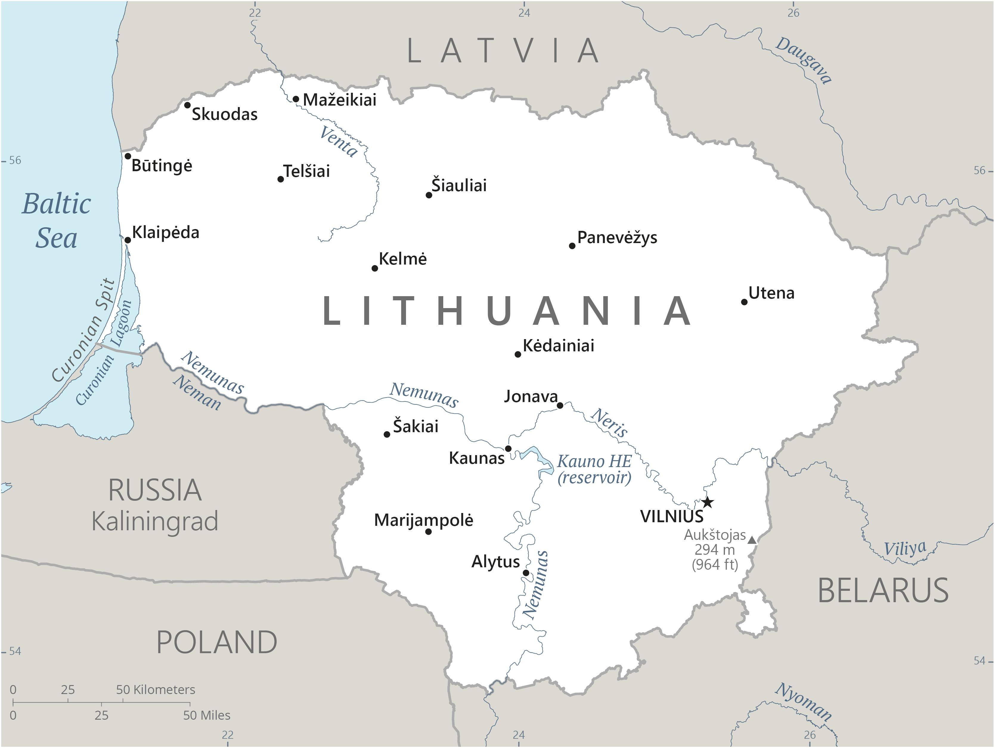
Lithuania is situated in a unique geographic location, surrounded by the Baltic Sea to the west, Poland to the southwest, Belarus to the east and south, and Latvia to the north, as shown on a map. The map depicts a country with a variety of landscapes, including undulating hills, coastal regions, rivers, and lush woods.
Every region, from historic castles to energetic cities, has a unique tale to tell. Beyond merely providing guidance, knowing the country's layout fosters a greater understanding of Lithuania's history and its place in the Baltic area.
Quick Facts About Lithuania
| Legal Name | Lithuania |
| Capital City | Vilnius |
| System of Government | parliamentary democracy |
| Total Land Area | 65,300 km2 |
| Population | 2,830,144 Million |
| Currency | The Euro |
| Dialling Code | +370 |
| Largest City | Vilnius |
| GDP | $79.86 billion |
| GDP Per Capita | 18687.00 USD |
| Official Language | Baltic language |
Geographical Overview Of Lithuania's Map
Lithuania, the largest of the three Baltic nations and a nation in northeastern Europe, has a complicated and lengthy past. It subsequently created the Polish-Lithuanian Commonwealth, an important political entity for two centuries, after once ruling much of eastern Europe as a formidable empire from the 14th to the 16th centuries.
Lithuania had brief periods of independence after centuries of Russian rule, which started in 1795, from 1918 to 1940 and during World War II when it was occupied by Germany.
Up until 1990, it was then forcibly merged into the Soviet Union as a component country. The unanimous declaration of independence by the newly elected Lithuanian parliament on March 11, 1990, marked a turning point. On September 6, 1991, the Soviet parliament publicly recognized this declaration.
By joining NATO and the European Union in 2004, Lithuania further cemented its place on the global scene. Vilnius's continued vitality and tenacity are demonstrated by the fact that it is now the capital of the country.
Climate Zones
Lithuania experiences a transition from a maritime to a continental climate, resulting in four distinct seasons.
- Maritime Influence (Western Lithuania):The Baltic Sea moderates temperatures in the western regions, leading to milder winters and cooler summers, with more precipitation.
- Continental Influence (Eastern Lithuania):As one moves eastward, the climate becomes more continental, characterized by colder winters with more snow and warmer summers.
- Temperature and Precipitation:Average January temperatures hover around -5°C (23°F), while July temperatures average around 17°C (63°F). Annual precipitation varies, with the southwestern coast of the Žemaitija Uplands receiving up to 930 mm, compared to central areas with around 540 mm. Rain accounts for three-quarters of all precipitation, and fog is common in spring and autumn.
See Also: Famous Landmarks In Japan You Must Visit
Major Cities On The Map Of Lithuania
- Vilnius: Lithuania's capital, Vilnius, is the cultural, political, and economic hub of the country. Gediminas Tower, Vilnius Cathedral, and the Gates of Dawn are just a few of the historic attractions that can be seen in the UNESCO-listed Old Town.
- Kaunas: The second-largest city, Kaunas, is well known for its vibrant arts scene and unique interwar modernist architecture. Famous structures like Kaunas Castle and Laisvės Alėja (Freedom Avenue) can be found in the city, which also organizes the highly regarded Kaunas Jazz Festival.
- Klaipėda: Lithuania's main seaport, Klaipėda, is a seaside city that offers access to the UNESCO-designated Curonian Spit. In addition to the yearly Sea Festival, which is a significant cultural event, the city's architecture clearly reflects its German past.
- Šiauliai: Known for the Hill of Crosses, Šiauliai is a potent representation of Lithuanian tenacity and faith. Cultural attractions like the Aušros Museum and the Photography Museum are also available in the city.
- Panevėžys: Panevėžys is a cultural and theatrical center in northern Lithuania. It is well-known for the yearly International Theater Festival and its Puppet Wagon Theater.
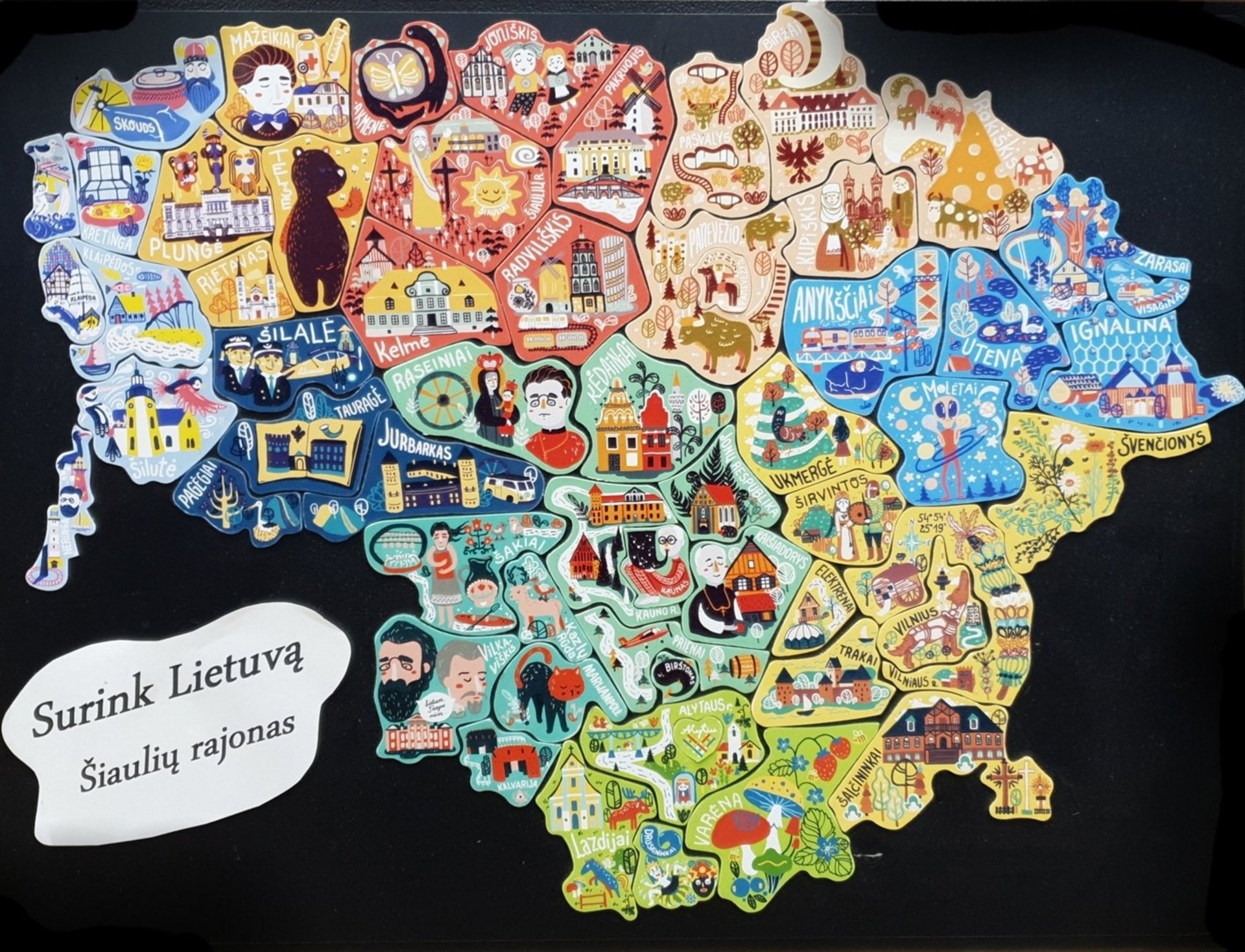
Administrative Divisions
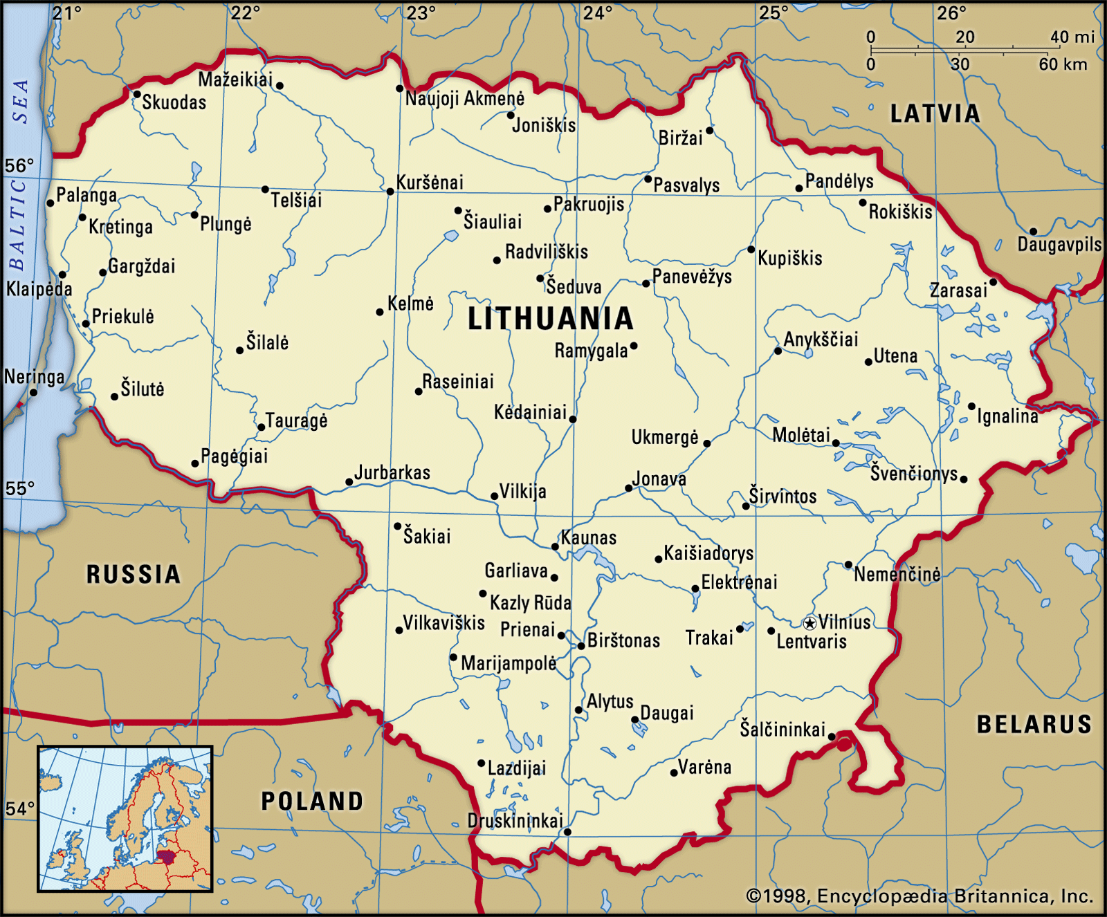
Lithuania is divided into 10 counties (apskritys), each named after its capital city. These counties are further subdivided into 60 municipalities (savivaldybe˙s), which include 9 city municipalities, 43 district municipalities, and 8 municipalities.
Each municipality is then divided into elderates (seniuˉnijos). This administrative structure, established in 1994 and refined in 2000, provides a clear framework for local governance and regional development.
Population Of Lithuania
Lithuania is home to an estimated 2,830,144 people, which is only 0.03% of the world's population. As a result, Lithuania is ranked 142 in the world for population. Covering 62,674 square kilometers of territory, the country has a population density of 45 persons per square kilometer. The median age of Lithuania is 42.3 years, and 68.2% of the population lives in urban areas.
Regions On The Map Of Lithuania
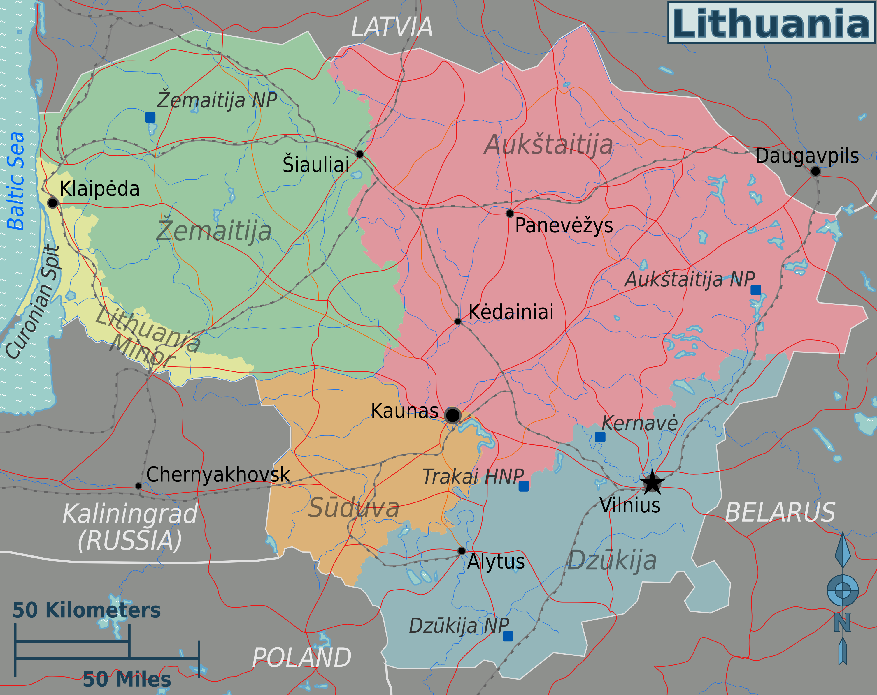
Every region of Lithuania has its own distinct personality and attraction. These areas have great historical and cultural significance despite not being recognized as official administrative units.
Aukštaitija (Highlands)
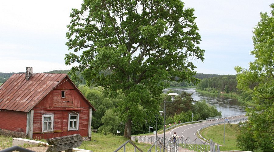
Aukštaitija, a region in eastern and northeastern Lithuania, is renowned for its clean lakes, thick woods, and undulating hills. With its emphasis on traditional wooden architecture and folk art, it is frequently referred to be the center of Lithuania's cultural legacy.
Žemaitija (Samogitia Or Lowlands)
The western Lithuanian area of Žemaitija is known for its low-lying terrain and rich traditions. Its unique dialect, strong sense of cultural identity, and historical significance in the Middle Ages have made this region famous.
Dzūkija (Dainava)
Its rich folk traditions have earned Dzūkija the nickname "land of songs" in southern Lithuania. Large forests that comprise a sizable amount of Lithuania's protected natural regions are what make the area famous.
Suvalkija (Sudovia)
Suvalkija, a region in the southwest of the nation, is renowned for its well-planned communities and lush agricultural terrain. This area is known for being the most developed historically, with a focus on development and education.
Lithuanian Minor (Mažoji Lietuva)
This region, which is in the westernmost portion of Lithuania, formerly comprised parts of what is now Russia's Kaliningrad region. Its closeness to the Baltic Sea and other areas has shaped its own cultural fusion.
Capital Of Lithuania - Vilnius
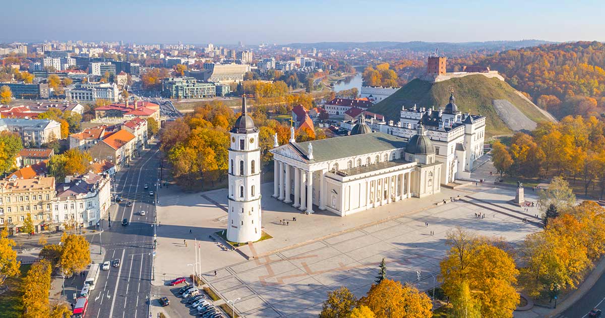
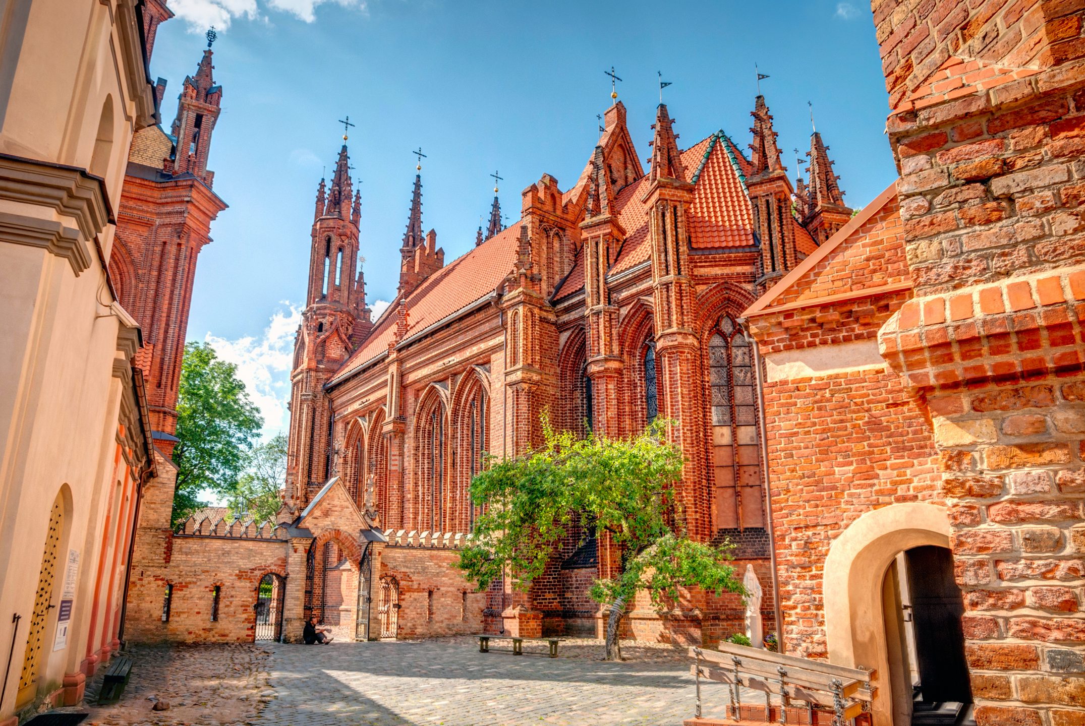
Lithuania's capital city of Vilnius is renowned for its baroque architecture, particularly in its medieval Old Town. However, the buildings that line the mostly cobblestone lanes of this district represent a variety of centuries and styles, ranging from the Gothic St. Anne's Church to the neoclassical Vilnius Cathedral. An entrance to the old city was previously guarded by the Gate of Dawn, a shrine with a revered image of the Virgin Mary from the 16th century.
Read Also: Petra, Mallorca - Top Sights & Hidden Gems
Types Of Map Of Lithuania
Political Map Of Lithuania
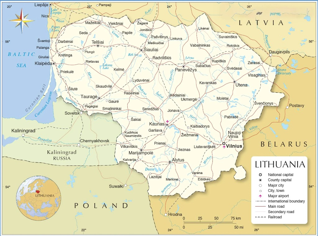
Lithuania is a unitary parliamentary republic that is based in Vilnius, the historic capital of the Baltic region. With the Seimas, a one-chamber parliament of 141 members, enacting legislation throughout their four-year mandates, the state's power is distributed through three key routes.
Under the close supervision of parliament, a president serves five-year terms as head of state and collaborates with a prime minister to lead the government. Ten counties divide the country into manageable territories, each of which is further subdivided into local towns. The country's legal system is based on civil law, and it starts with the Supreme Court and continues through appeals, regional, and district courts.
The country's borders, which touch Russia's Kaliningrad Oblast to the southwest, Latvia to the north, Belarus to the southeast, and Poland to the south, reveal its location in Europe. A network of urban life is formed by Lithuania's cities, which stretch from the busy streets of Vilnius to the cultural hub of Kaunas, the Baltic port of Klaipėda, and the northern centers of Šiauliai and Panevėžys.
Its western border adorned by the waves of the Baltic Sea, these communities emerge from a region endowed with rivers and lakes, forming a mosaic of both natural and man-made geography that characterises contemporary Lithuania.
Physical Map Of Lithuania
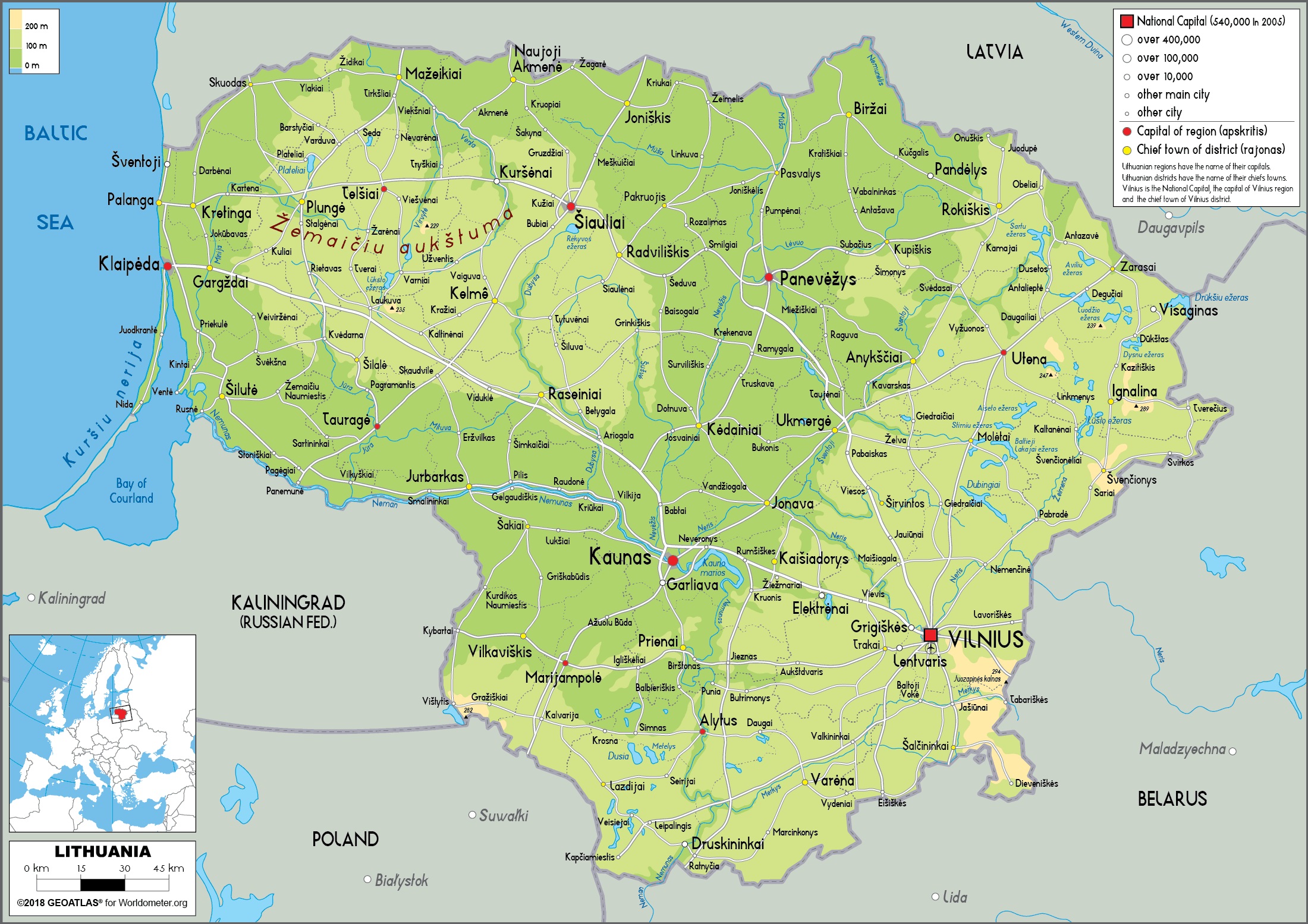
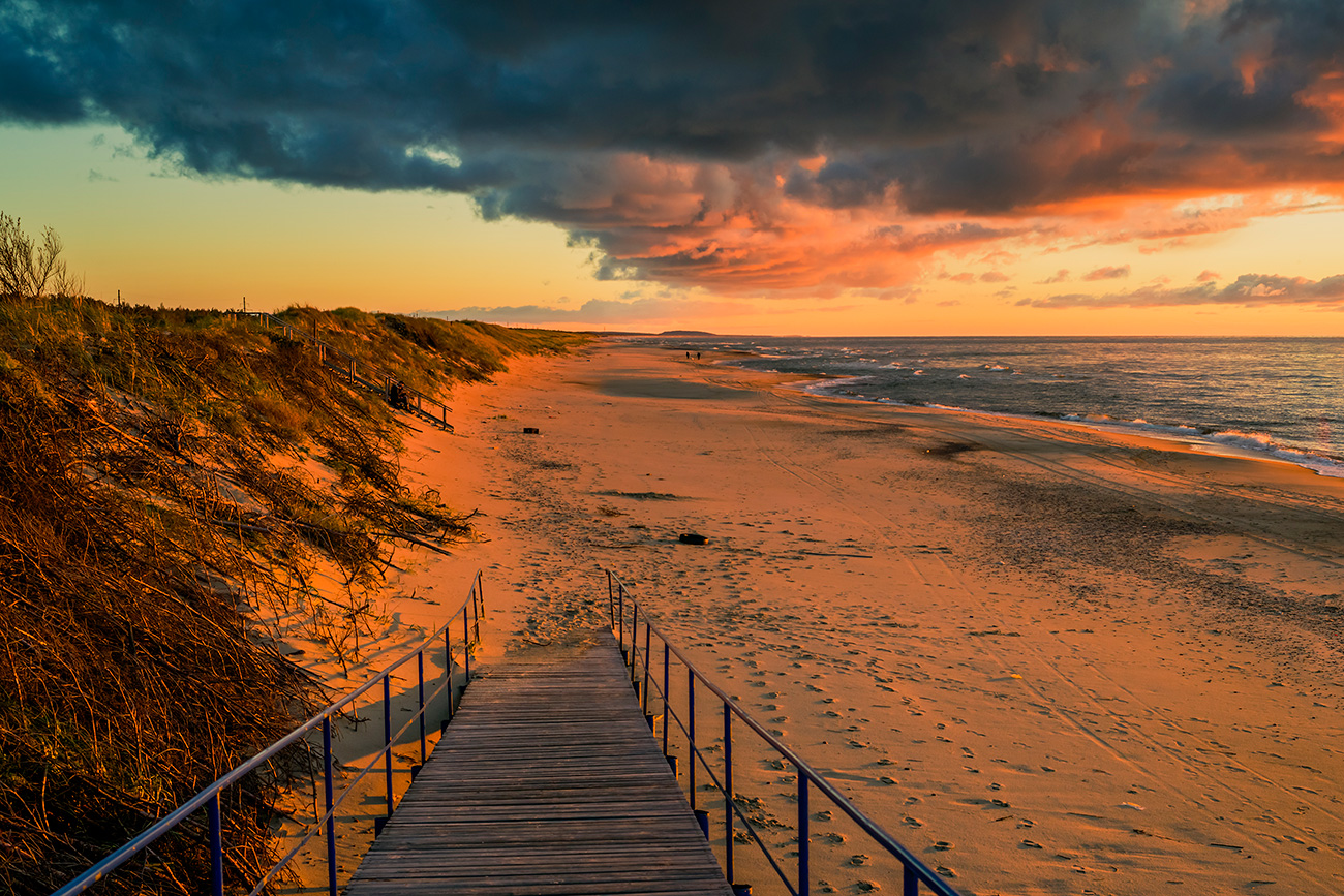
Lithuania, whose Ice Age forces sculpted a masterpiece of undulating lowlands covered in verdant woods and speckled with glistening lakes, is a region of soft contrasts. The terrain rises to meet two different highlands because the softer Samogitian swells in the northwest and the rocky Baltic heights in the east. While the stunning Curonian Spit acts as a natural barrier, shielding the serene Curonian Lagoon from the open waters, the country's western shoreline welcomes the Baltic Sea with golden beaches.
Lithuania's liquid spine is the powerful Nemunas River, whose waters are joined by innumerable lakes and tributaries that give the country life. While huge forests offer lumber and wildlife refuge, these fertile plains produce harvests of potatoes, cereals, and flax.
This abundance of wildlife, from the rolling hills to the tranquil shoreline, makes Lithuania a destination for anyone looking to experience the embrace of nature and supports a flourishing tourism industry that honors the wild nature of the nation.
Road Map Of Lithuania
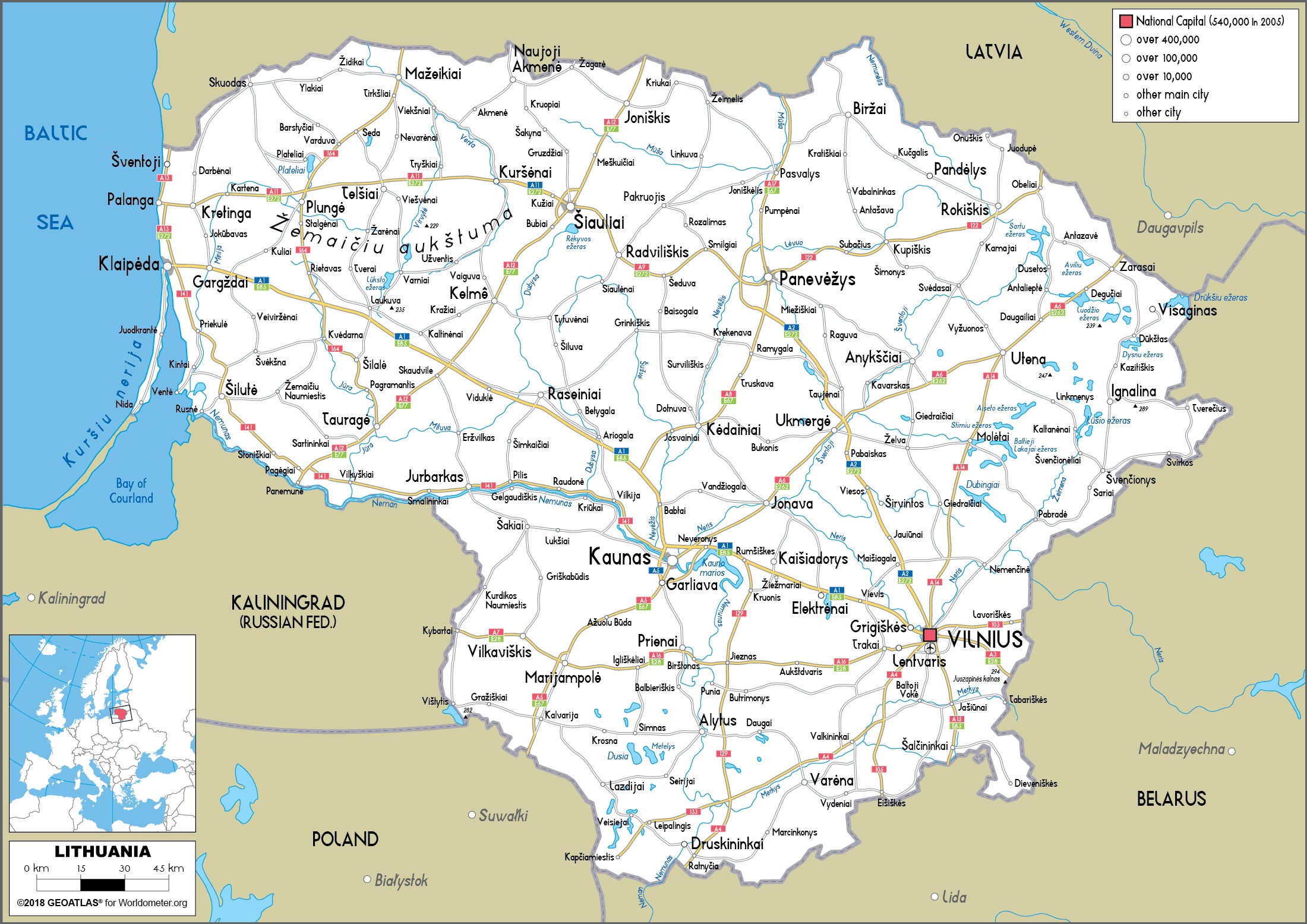
The road system in Lithuania connects cities, towns, and rural areas across the nation, providing a smooth and pleasurable travel experience. Smooth travel is made possible by contemporary highways and picturesque byways, which also offer stunning views of Lithuania's scenery.
The A1 highway, which connects Vilnius, Kaunas, and Klaipėda, and the A2 highway, which connects Vilnius to Panevėžys, are important thoroughfares. While the E67 (Via Baltica) facilitates international travel by connecting Lithuania to Poland and Latvia, the A11 road provides a scenic route to the Baltic coast. The road network features easy border crossings to adjacent countries, plenty of convenient stop spots, and well-maintained infrastructure with clear signs.
Road travel is a wonderful experience in Lithuania, providing the chance to see picturesque villages and a variety of landscapes. Notable locations include the capital city of Vilnius, which is well-known for its ancient sites; Kaunas, which is a UNESCO World Heritage Siteand has a beautiful Old Town; and Trakai, which is well-known for its island castle and tranquil lakes.
Simple Map Of Lithuania
A simple map of Lithuania often focuses on the most essential information, such as national borders, major cities, and perhaps the largest rivers. It provides a clear, uncluttered overview, ideal for quick reference or for those who need a basic understanding of the country's layout without overwhelming detail. These maps are excellent for introductory purposes or for understanding Lithuania's location within the broader European context.
Locator Map Of Lithuania
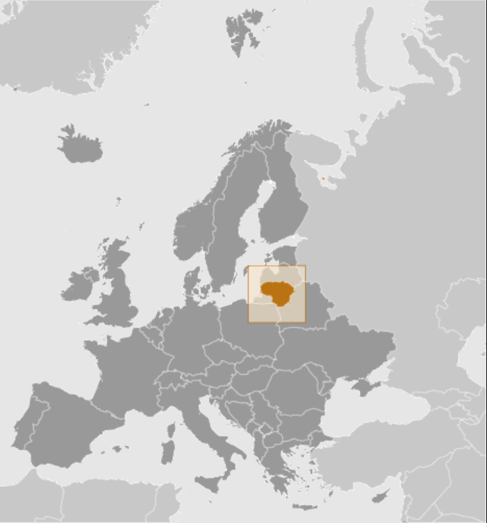
A locator map of Lithuania places the country within a larger geographical context, typically showing its position on the European continent or even globally. It uses a smaller inset map or a highlighted region on a larger map to indicate Lithuania's location relative to its neighbors and other significant landmasses.
This type of map is crucial for understanding Lithuania's geopolitical significance and its connections to the rest of the world. It provides immediate spatial context, answering the fundamental question of "where is Lithuania?"
Attraction Map Of Lithuania
An attraction map of Lithuania is designed to guide visitors to the country's most popular tourist destinations and points of interest. This could include historical sites like Vilnius Old Town and Trakai Castle, natural wonders such as the Curonian Spit and Aukštaitija National Park, and cultural landmarks like the Hill of Crosses.
These maps often feature symbols or icons to represent different types of attractions, along with roads and other relevant infrastructure to aid in planning itineraries. An attraction map is a traveler's best friend, revealing the cultural and natural treasures waiting to be explored.
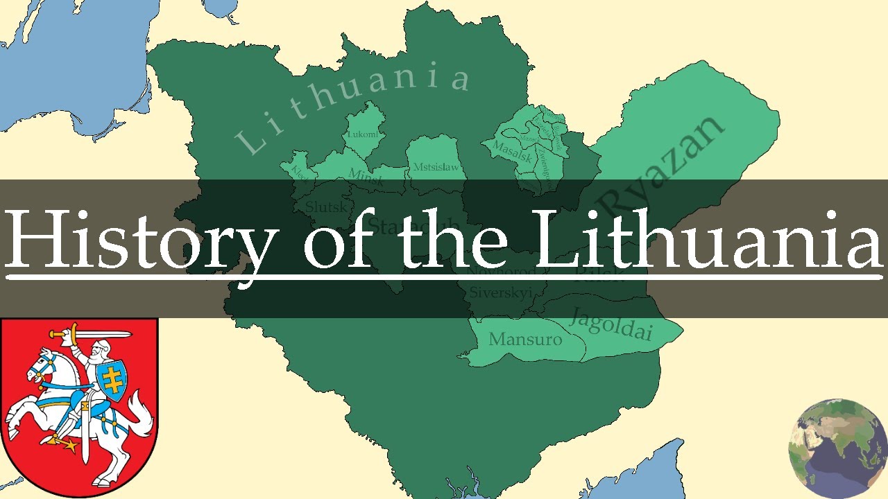
Historical Map
Lithuania's historical maps serve as windows into the past, capturing the transformations that shaped this Baltic nation over centuries. These cartographic records chronicle the Grand Duchy of Lithuania's medieval power, the golden age of the Polish-Lithuanian Commonwealth, and the challenges of Imperial Russian rule.
Each shifting border line on these maps tells a story of triumph or tribulation, documenting moments of cultural, political, and religious evolution. From its pagan roots to its embrace of Christianity, these maps trace the spread of Catholic influence from the West and Orthodox traditions from the East, reflecting Lithuania’s role as a crossroads of civilizations.
These maps also showcase the country's rich history and tenacity by exploring the heritage of sacred locationsthat served as community anchors, commercial routes that promoted riches and exchange, and battlefields where armies fought. While subsequent maps documented the growth of new power centers and the ebb and flow of political tides, medieval cartographers documented the rise of large cities.
Today, tourists can have better understanding of Lithuania's identity thanks to these historical charts. They demonstrate how the country, sandwiched between the East and the West, combined many influences to establish a unique cultural identity that has persisted. These maps, which range from old manuscripts to contemporary replicas, provide important insights into the forces that produced contemporary Lithuania by preserving the visual narrative of a people that triumphed despite separation and conquest.
History of the Lithuania : Every Year
Satellite Map
Satellite views of Lithuania paint Earth's portrait from above, revealing the nation's natural canvas in stunning detail. The land unfolds in a spectrum of colors - dark greens of ancient forests, patchwork browns and golds of farmlands, and the silvery ribbon of the Baltic coastline. Cities appear as intricate webs of streets and buildings, their patterns telling stories of growth and human settlement across the centuries.
These orbital images serve multiple purposes, transforming how we understand and manage Lithuanian territory. Urban planners study city expansion through these views, while environmental scientists track forest health and coastal changes along the Baltic shore. The images reveal hidden patterns of land use, from the geometric shapes of modern agriculture to the organic spread of woodlands.
In times of crisis, these maps become vital tools, guiding emergency responses to floods or fires, while researchers use them to monitor environmental shifts across seasons and years. Through these space-born eyes, Lithuania's landscape becomes a living document, recording changes both natural and human-made, offering insights that shape decisions about the nation's future development and conservation.
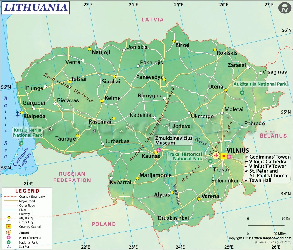
National Parks In Lithuania
Lithuania's five national parks capture the essence of the nation's natural and cultural heritage.
Aukštaitija National Park
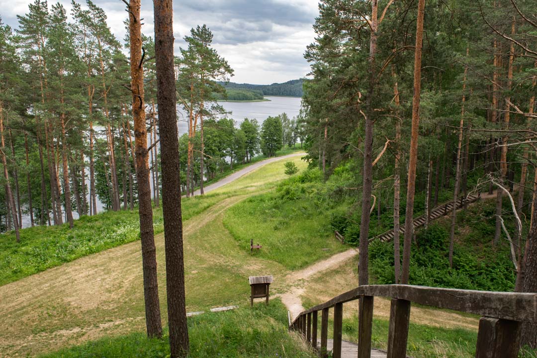
The nation's first national park, Aukštaitija, protects elk, bears, and wolves amid its old forests and immaculate lakes. Its routes, which have established a standard for Lithuanian conservation since 1974, offer adventurers to hike, bike, or paddle through untamed terrain.
Dzūkija National Park
The largest national park, Dzūkija, is located in the center of Lithuania's woodlands. Both natural wonders and cultural traditions are preserved in this enormous area of peat bogs and woods. Within its borders, long-standing traditions and traditional mushroom gathering continue to exist, bridging the gap between the past and present.
Curonian National Park
A natural wonder, the Curonian Spit is where wind-sculpted dunes grow between the Curonian Lagoon and the Baltic Sea. Sea gusts constantly sculpt the golden dunes of this UNESCO World Heritage site, creating a constantly shifting environment. Rare birds fly over the hiking and cycling routes that meander through this fragile ecosystem.
Žemaitija National Park
Western Lithuania's undulating hills and thick forests are on display in Žemaitija National Park. At its center, Lake Plateliai's waters stretch out over the terrain. Ancient woods are traversed by deer and wild boar, and pathways allow tourists to explore on foot, bicycle, or horseback.
Trakai National Park
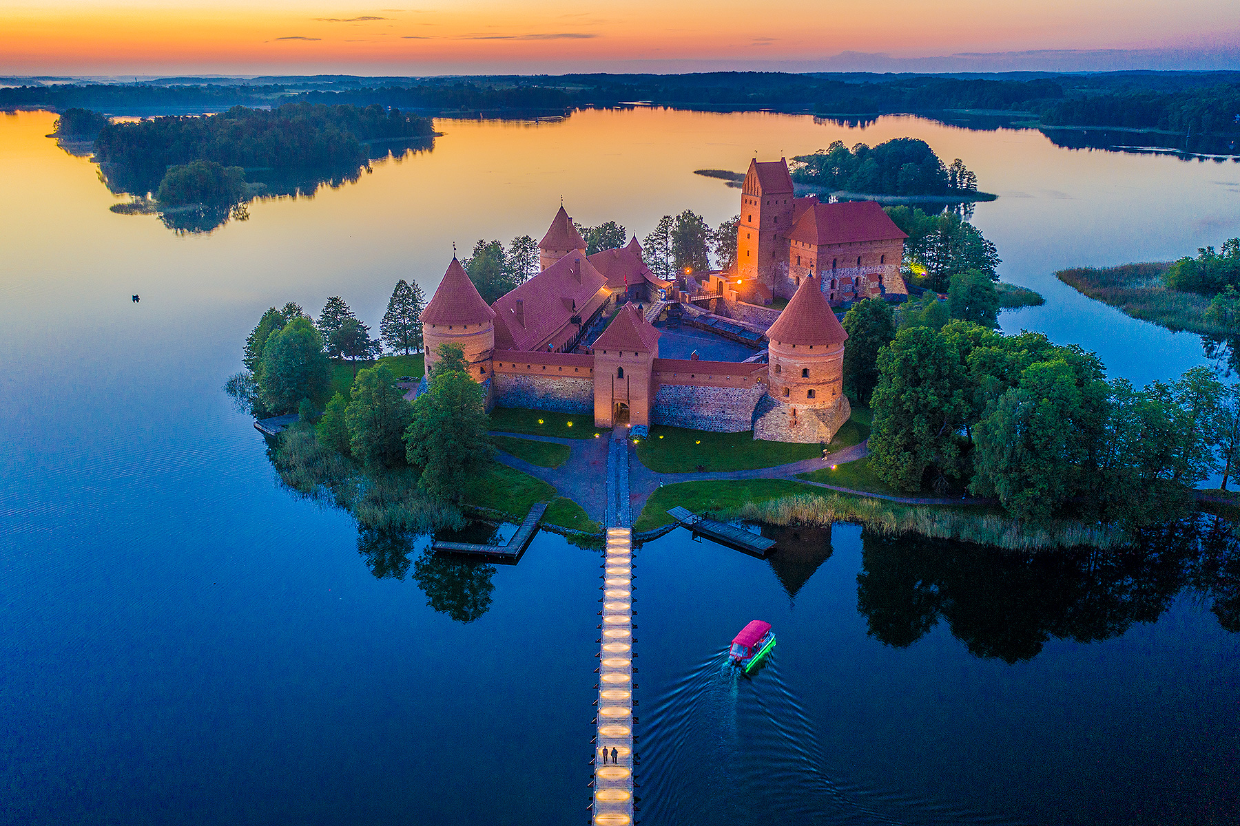
Nature and history are interwoven at Trakai Historical National Park. Stories of Lithuanian princes and Karaite merchants are told by its medieval island castle that rises from the waters of Lake Galvė. This unique preserve offers visitors a trip through time amidst breathtaking settings while safeguarding the architectural masterpieces of centuries past as well as the natural beauty of its lakes.
These five parks, which individually preserve diverse landscapes and provide visitors with unique experiences, are the crown jewels of Lithuania's natural heritage.
Top Attractions On The Map Of Lithuania
Vilnius Old Town
Ancient structures in a variety of styles, from baroque and Gothic cathedrals to the neoclassical Town Hall, are the main attraction of Senamiestis, the vibrant, well-preserved Old Town. Vilnius University is a 16th-century institution, and the medieval Gediminas Castle Tower provides views of the city. Amber jewelry, wood sculptures, and Lithuanian cheese may be purchased from small shops on tiny alleyways, and the region is dotted with taverns, clubs, and international restaurants.
Trakai Island Castle
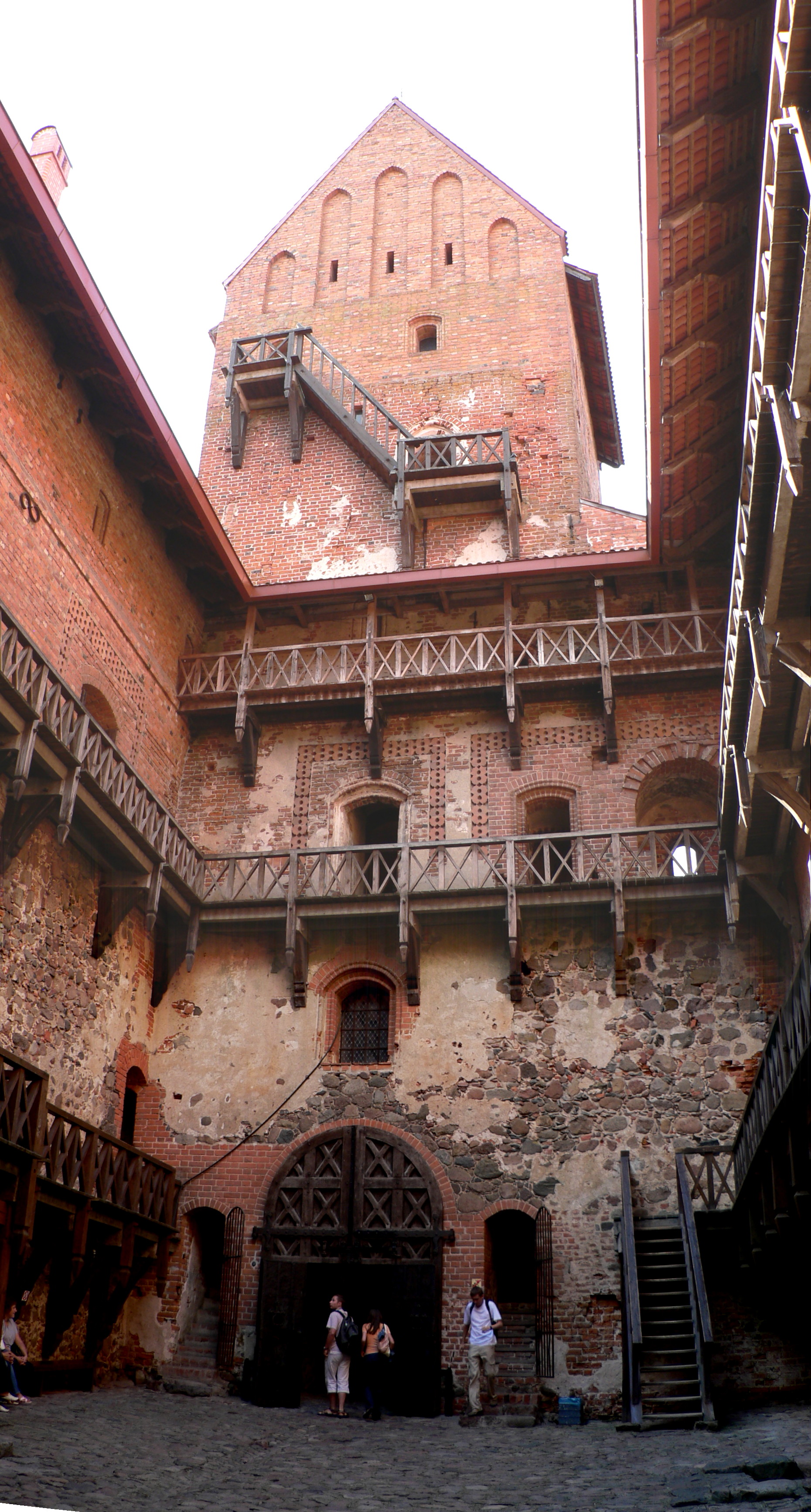
Trakai Island Castle is situated on an island in Lake Galvė in Trakai, Lithuania. Kęstutis started building the stone fortress in the 14th century, and his son Vytautas the Great finished the main construction in 1409. He passed away in the castle in 1430.
Curonian Spit
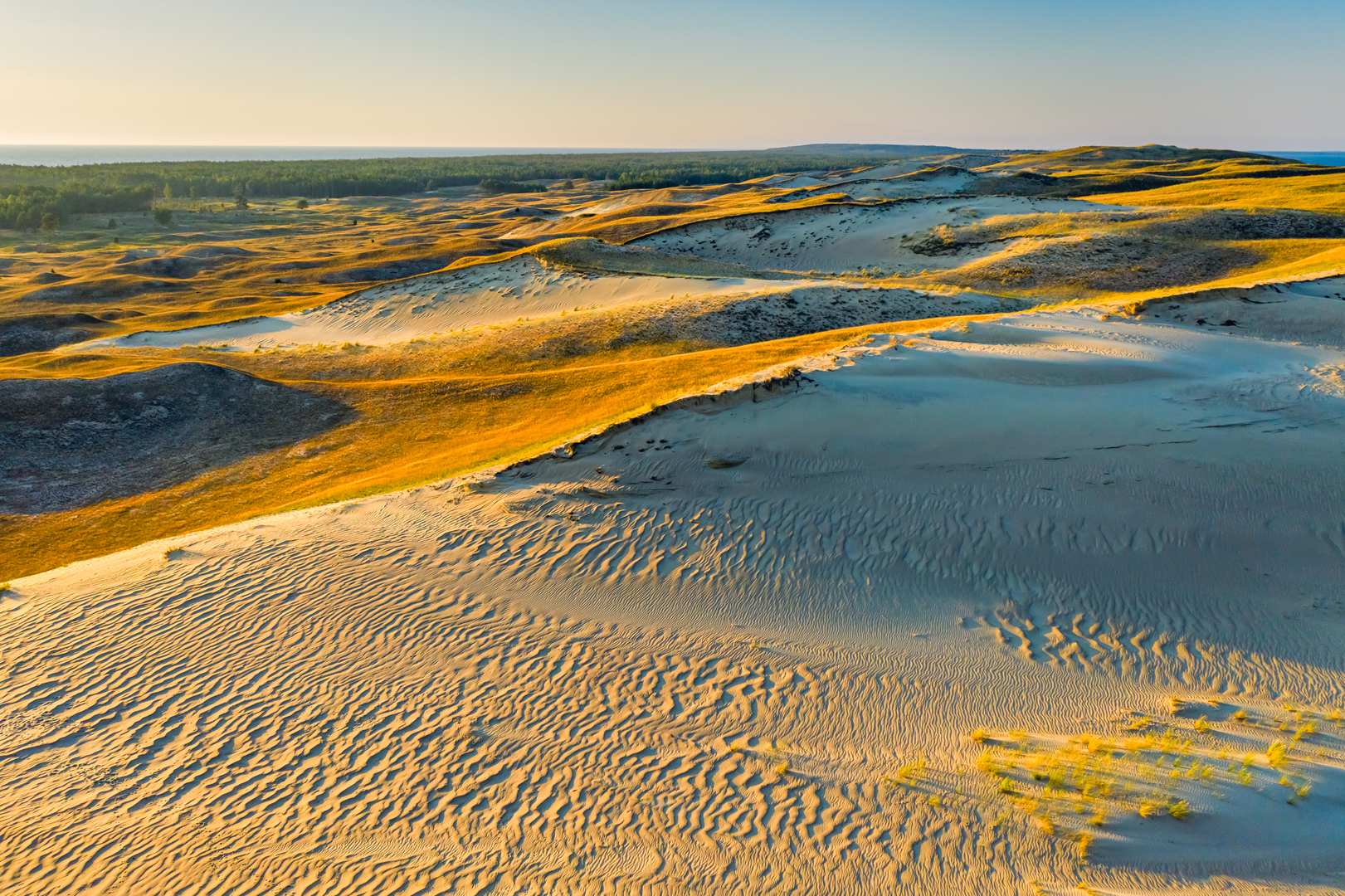
The Curonian Lagoon and the Baltic Sea are divided by the 98-kilometer-long, thin, curving sand-dune spit known as the Curonian Spit. Both Lithuania and Russia share it as a UNESCO World Heritage Site.
Hill Of Crosses
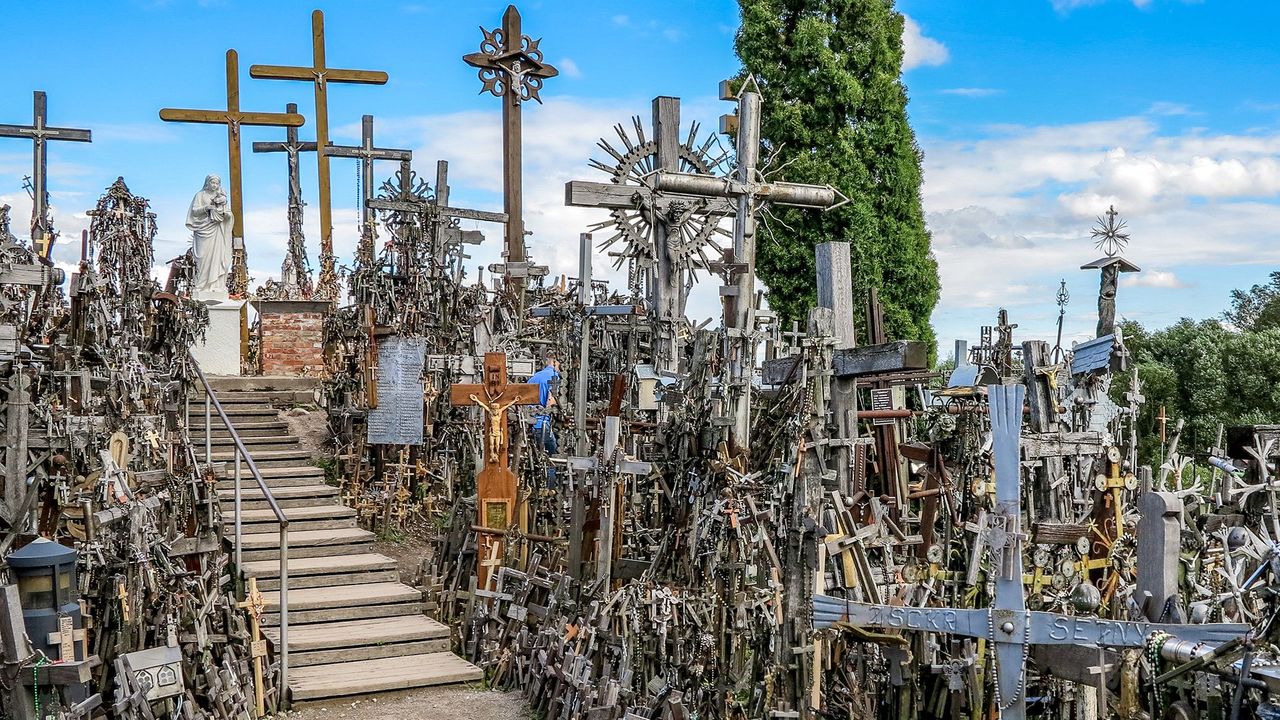
The Hill of Crosses is a pilgrimage site located in northern Lithuania, approximately 12 kilometers north of the city of Šiauliai. Although it is unclear exactly when the custom of placing crosses on hills began, it is thought that the first crosses were erected on the former Jurgaičiai or Domantai hill fort following the 1831 revolution.
Gediminas Castle Tower
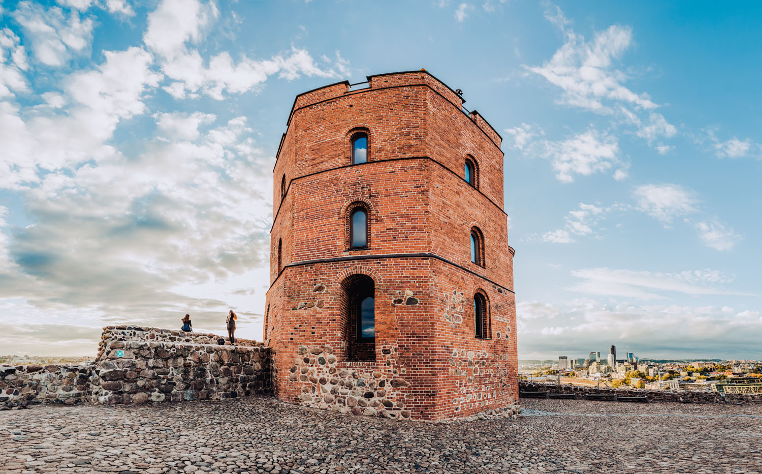
Situated atop Gediminas Hill in Vilnius, Lithuania, the Upper Castle's remnants are known as Gediminas' Tower. It contains an observation platform with picturesque views of the central business district and Vilnius Old Town.
Palanga Amber Museum
A division of the Lithuanian National Museum of Art, the Palanga Amber Museum is located in Palanga, Lithuania, close to the Baltic Sea. The Palanga Botanical Garden encircles the renovated 19th-century Tiškevičiai Palace, which serves as its home.
Kaunas Castle
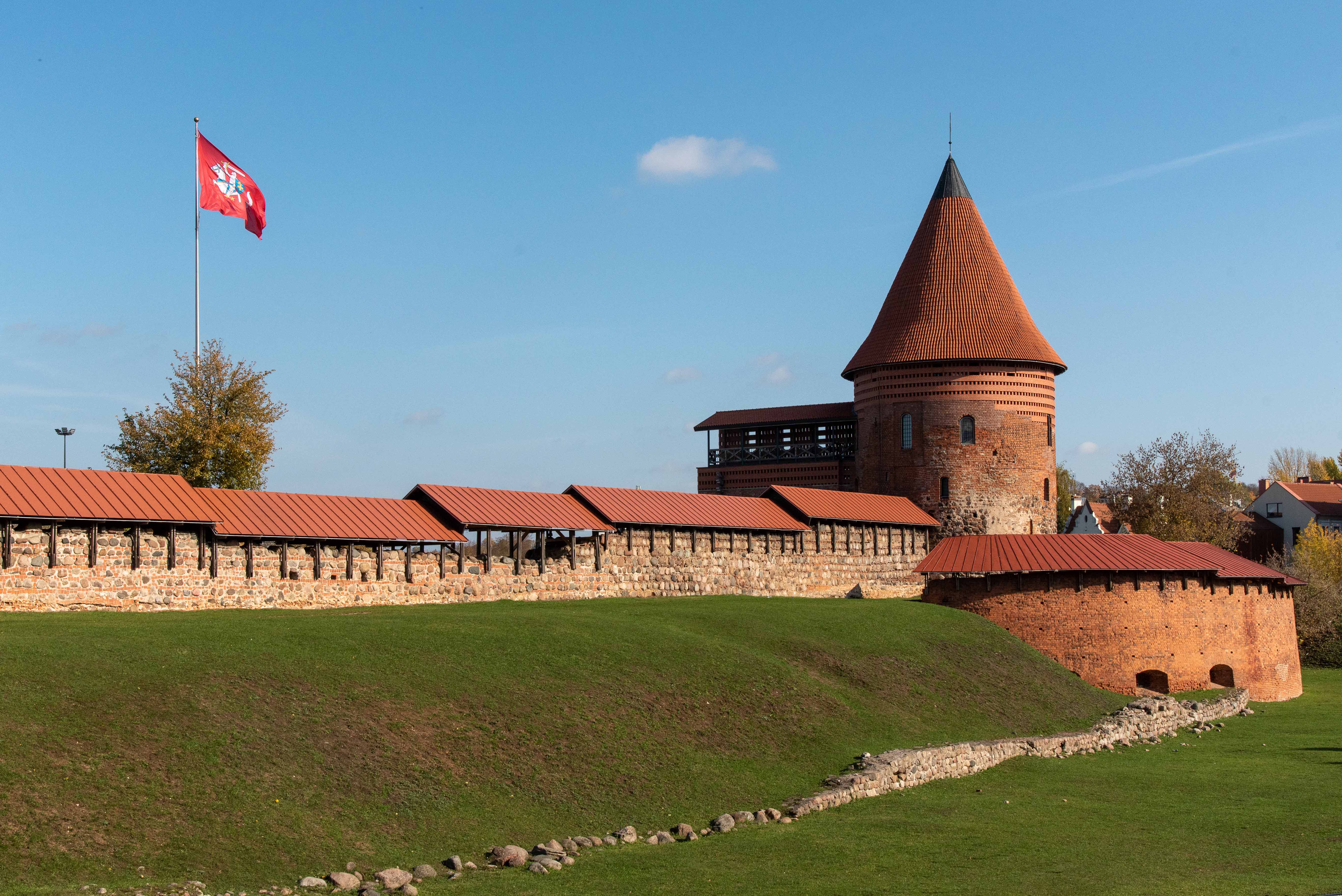
Kaunas Castle is a medieval castle located in Lithuania's second-biggest city, Kaunas. It was constructed in the Gothic style in the middle of the fourteenth century, according to archeological data. Its location, a rise on the Nemunas River's banks close to where it joins the Neris River, is advantageous.
Dialing Code Of Lithuania
Lithuania's country code is +370. When phoning from outside of Lithuania, this code needs to be entered before the local number.
Currency Of Lithuania

As a condition of joining the European Union, Lithuania adopted the Euro (EUR) as its official currency on January 1, 2015. The Litas (LTL), Lithuania's previous national currency, was replaced by the Euro, marking a significant turning point in the country's economic integration with Europe. Simple transactions both inside and outside of the Eurozone are made possible by the Euro, which is represented by the sign "€" and is divisible into 100 cents.
Lithuania's financial stability has been reinforced by the Euro's adoption, which has also made travel and trading with other EU nations easier. While Lithuanian coins have a national side and a common side, Euro banknotes are the same in all member nations. The Vytis, a knight on horseback, is a representation of Lithuania's historical and cultural legacy on the Euro coins.
Flag Of Lithuania
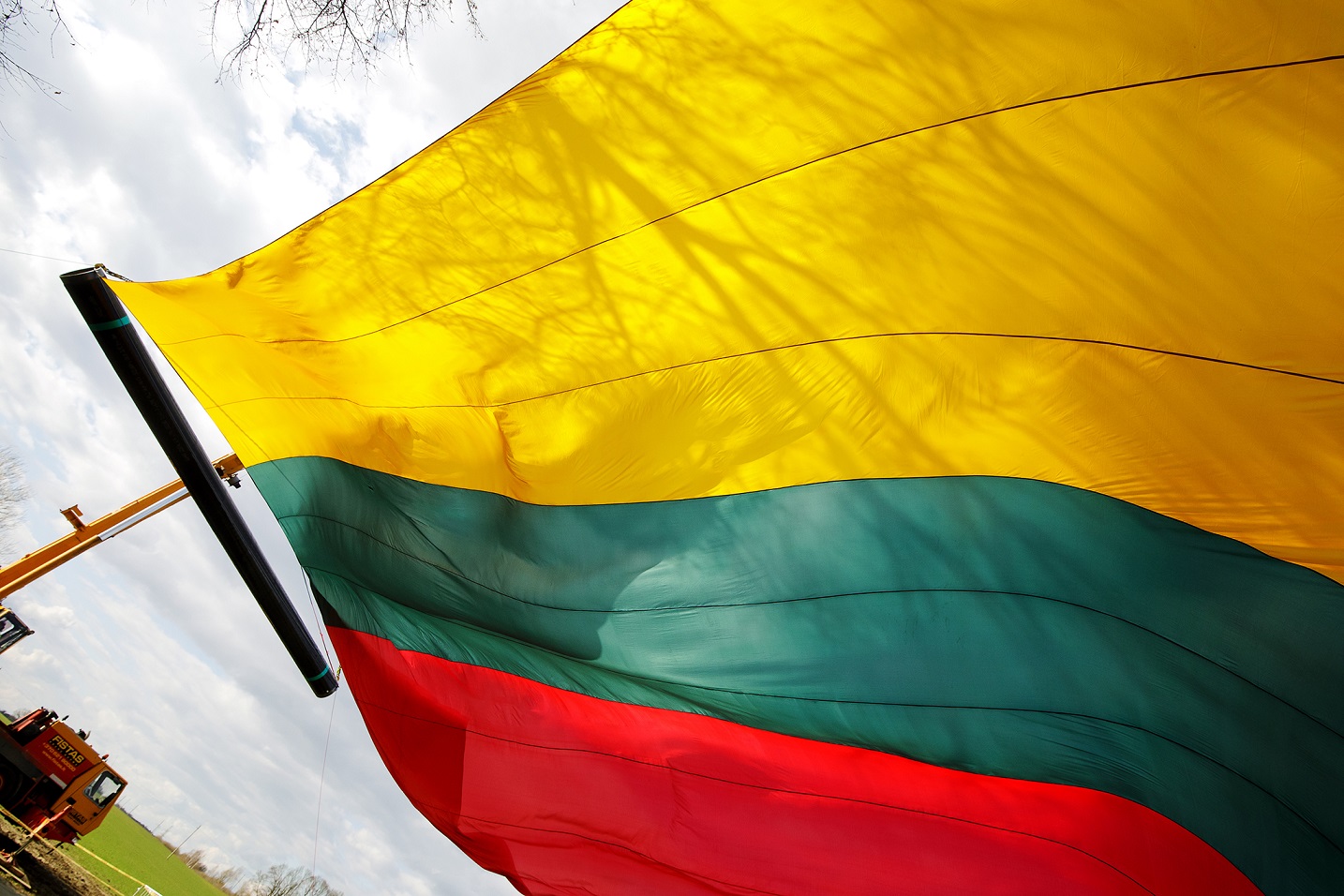
The Lithuanian flag, which is a dynamic tricolor of red, green, and yellow, represents the energy of the country. After being prohibited during Soviet control, it was re-embraced in 1988 as a symbol of the country's rebirth after having been adopted in 1918 during a brief era of freedom. This striking symbol now proudly symbolizes Lithuania's enduring identity and its path towards freedom after being recently adjusted to a 3:5 aspect ratio in 2004.
10 Interesting Facts About Lithuania
1. Once a European Powerhouse: Reaching from the Baltic Sea to the Black1 Sea, the Grand Duchy of Lithuania was the biggest nation in Europe in the fourteenth century.
2. It began its quest to regain sovereignty on March 11, 1990, when it became the first Soviet republic to declare independence from the USSR.
3. Among the oldest languages in the world, Lithuanian is said to be the most archaic Indo-European tongue still in use today, keeping numerous linguistic traits that other languages have lost.
4. The capital city of Vilnius is host to one of Europe's largest and best-preserved medieval townscapes, the Old Town, which is recognized as a UNESCO World Heritage Site.
5. Lithuania is home to the Hill of Crosses, a remarkable site with thousands of crosses placed by pilgrims and visitors, symbolizing faith, hope, and resistance.
6. Lithuania has won numerous medals in international basketball competitions, solidifying its status as a basketball superpower. Basketball is more than simply a sport in Lithuania; it is a national passion.
7. A World Heritage Site recognized by UNESCO, the Curonian Spit is a picturesque sand-dune peninsula that is shared with Russia and is renowned for its breathtaking scenery and exceptional natural beauty.
8. In Lithuania, beekeeping has a long history, and making honey is still a beloved craft. Medieval in origin, mead is a honey-based alcoholic beverage that is well-known throughout the nation.
9. In 1989, the Baltic Way was a nonviolent demonstration in which Lithuanians, Latvians, and Estonians joined together to create a human chain that stretched more than 600 kilometers and called for independence from Soviet domination.
10. Festivals such as Užgavėnės, a pre-Lenten carnival with masks, traditional dishes, and rituals to ward off winter and welcome spring, are examples of how Lithuania celebrates its cultural history.
FAQs About Map Of Lithuania
What Was Lithuania Called Before?
It was known as the Grand Duchy of Lithuania, later part of the Polish–Lithuanian Commonwealth, and then the Republic of Lithuaniabefore Soviet occupation.
What Is Lithuania Best Known For?
Lithuania is famous for Vilnius Old Town, basketball, the Curonian Spit, and its medieval history.
What Countries Border Lithuania On The Map?
Lithuania borders Latvia, Belarus, Poland, and Russia (Kaliningrad).
What Is The Full Name Of Lithuania?
The official name is the Republic of Lithuania(Lietuvos Respublikain Lithuanian).
Does Lithuania Have A Coastline?
Yes, Lithuania has a relatively short coastline along the Baltic Sea, approximately 99 kilometers (62 miles) long, which includes the unique Curonian Spit.
What Is The Largest River In Lithuania?
The Nemunas River is the longest and most significant river in Lithuania, flowing through the central part of the country.
How Is Lithuania Administratively Divided?
Lithuania is divided into 10 counties (apskritys), which are further subdivided into 60 municipalities (savivaldybe˙s), and then into elderates (seniuˉnijos).
Conclusion
The Lithuanian map serves as more than just a location guide. It displays the strategic significance of the country and its close ties to the sea and its neighbors. One can learn about Lithuania's evolution by looking at the map, which shows both its current cities and its historical sites.
The people's culture and identity are greatly influenced by their geographic location. Examining Lithuania's map offers a chance to learn about its history, current situation, and position within the larger European framework.
You Might Also Like: Scottish Currency - A Practical Guide For Tourists
Jump to
Quick Facts About Lithuania
Geographical Overview Of Lithuania's Map
Major Cities On The Map Of Lithuania
Regions On The Map Of Lithuania
Capital Of Lithuania - Vilnius
Types Of Map Of Lithuania
National Parks In Lithuania
Top Attractions On The Map Of Lithuania
Dialing Code Of Lithuania
Currency Of Lithuania
Flag Of Lithuania
10 Interesting Facts About Lithuania
FAQs About Map Of Lithuania
Conclusion

Michael Rachal
Author
Michael Rachal believes that luxury lies in the details. With over 20 years of experience in the luxury travel industry, he has crafted hundreds of bespoke itineraries for clients seeking personalized, unforgettable experiences.
Whether guiding clients through private cultural tours or curating culinary journeys with world-renowned chefs, Michael ensures that each trip is tailored to perfection.
His ability to anticipate needs and exceed expectations has earned him a reputation as a leading expert in luxury travel.

Finn Wilde
Reviewer
For Finn Wilde, the wilderness is more than just a destination - it’s a way of life. Over the past decade, he has led multiple expeditions in some of the world’s most remote regions, from the icy fjords of Greenland to the rugged trails of Patagonia.
Finn emphasizes sustainability in all of his adventures, helping participants connect with nature while promoting responsible exploration. His expeditions inspire individuals to explore the great outdoors while fostering a deep respect for the environment.
Latest Articles
Popular Articles